Question more on the 'academic interest' side: weren't there in the past old-style RNAV approaches that included coordinates for each waypoint, for which it was legal and appropriate to enter the waypoints manually if you had a legal RNAV system but not an approach database? Or were those all DME RNAV and not GPS?
VOR/DME RNAV, suitable for use on the old KNS 80 for example. And you didn't enter lat/long, you entered frequency/radial/distance. There was no database on the KNS 80, and I'm not aware of any other VOR/DME RNAV units for small airplanes besides the KNS 81. I don't know what the difference between the 80 and 81 was, but I've never actually seen an 81 in person or even in a picture in an airplane.
I haven't shot an approach with a KNS 80 (though I'm tempted to do so now, while there are still a few left!) but I have flown direct on a cross-country flight with it. Not as easy as punching in direct-to, you definitely need a chart so you can plot out the reference points, but it's a pretty cool unit, really an advanced analog computer. I like 'em enough that if I bought a plane with one, I'd probably leave it in as the #2 nav.
")
The way they worked is that you could enter up to four waypoints using frequency (of the VORTAC or VOR/DME), radial, and distance. Then, that point in space acted like a "virtual VOR" and you could twist your OBS and fly a course to or from that point. By entering more than one, you could flip from one to the next. It'd be significantly more difficult than flying a GPS approach loaded from a database!
But do any of the old waypoint-by-waypoint RNAV approaches exist anymore? Are they legal for GPS, or do can you only use them with the old rho-theta equipment? (Or am I completely delusional and making them up entirely?)
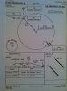
Thanks to Ron for posting the 50I and TRK reference - I haven't seen one of these approaches in a long time, kinda cool that some still exist! I would speculate that the only reason those particular examples exist is that they are "or GPS" approaches with the overlay. It's been around 10 years since I've seen a VOR/DME RNAV approach without a GPS overlay.
Thanks to a little Google-fu, here are the five remaining VOR/DME RNAV approaches, all with a GPS overlay:
TX: KBRO VOR/DME RNAV or GPS RWY 35
IN: 50I VOR/DME RNAV or GPS RWY 27
KS: K59 VOR/DME RNAV or GPS RWY 16
WI: C47 VOR/DME RNAV or GPS RWY 17
CA: KTRK VOR/DME RNAV or GPS-A
 )
)