Slacklines, where to find them in notams?

MountainDude

Cleared for Takeoff
PoA Supporter
Joined
Jul 29, 2011
Messages
1,466
Display Name
MountainDude
Home Airfield
KPDX
The slackline that knocked down to helicopter was in the middle of nowhere: 33°08'28.3"N 111°04'17.0"W

If you are flying XC from point A to point B, and there is a slackline far away from either point A or B, how would you know about it?
What airport was the notam associated with?
 
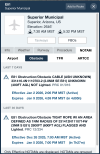
1767469558250.png
Present TFR for recovery is around the second NOTAM. This is from the airport close to the route and departure, Superior AZ in Fly-Q. No need to do the whole route to have this pop up. Just the closeby airport would have been good enough.
 
Last edited:
I just did a mock standard briefing from LUF-DMN.
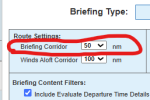
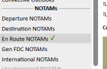
I had to select enroute "other" notams (it's not a default).
This is a fairly short XC, yet the briefing is a 70 page PDF.
The slackline/tight rope is mentioned on page 43, buried among many other notams.
I'd estimate that the chances of a pilot finding this notam for a routing VFR flight are essentially zero.
What if you actually call a briefer?
 
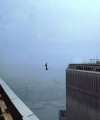
Holy crap I looked it up and when it showed people doing this crazy hobby I assumed that what these pilots hit was something else maybe something industrial what in the actual hell?
 
What if you actually call a briefer?
Not sure if they would have picked that one out of 30-40 notams along the route. And how many pilots would actually want to listen to a briefer reading pages of notams?
 
Not sure if they would have picked that one out of 30-40 notams along the route. And how many pilots would actually want to listen to a briefer reading pages of notams?
I do. They're must better at sifting through them than I am. But I also don't fly at 600' AGL away from airports.
 
Something created by college liberal arts backwoods communist hippy baristas who got tired of hacky sack. Sort of..... :biggrin:

 
Note that by and large, nothing under 200' AGL requires getting the FAA involved. Lots of 199' towers around here to escape that.
 
How many of these lines are 2500 AGL vs 300?
 
The format still sucks-- they don't even give you decimal lon/lat to copy/paste, and it looks like the most recent one is malformed. Really beautiful area; it doesn't exactly surprise me that people would do this there. That said, I've flown out of E81 around Picketpost, over the ridge to the SW and I did not think of cables across the canyon. I can only imagine this would be more on the helicopter pilots' radars, but evidently not always.
 

Attachments

  • Screenshot 2026-01-05 at 11.33.14 AM.png
    Screenshot 2026-01-05 at 11.33.14 AM.png
    212 KB · Views: 8
Back
Top