Proliferation of low-level UAS notams

Let'sgoflying!

Touchdown! Greaser!
Joined
Feb 23, 2005
Messages
21,873
Location
west Texas
Display Name
Dave Taylor
Home Airfield
KMRF
For low-level flyers:

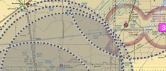
What do you think of all the UAS-notamed airspace we are seeing, usually 0-400’agl.
We’ll never see the drone that hits us b/c they are so small, and no adsb - so the chart markings do nothing.

The airspace is not a tfr, so they aren’t keeping us out; they aren’t preventing us from continuing our work (I’m survey; 100’ agl)

So the purpose of the notam is not to prevent a collision.

It’s like they notam it to deflect blame after an incident.
Should we notam all the airspace we use, for the same reason?

There’s a lot of us down in the weeds; I’ve seen geomag survey, ag, pipeline, ranchers, military, LE. If we all have notams issued, the charts would be so messy everyone would ignore them.

I’m don’t think the notams serve any preventive function and should be removed.
The drone flyers should see and be seen, possibly with adsb, like the rest of us.
 
Some drones are so small that any ads-b equipment would be too heavy to carry
 
Agreed. NOTAMs are a hot mess. Too much info is as bad as too little. I also don't fly a rotary wing aircraft, not am I spraying crops, so I just ignore the the UAS items. If I'm that low hitting a drone is probably the least of my concerns.

I did get burned this week by assuming I knew the NOTAMS - and learned a valuable lesson. My home aerodrome has a permanent NOTAM indicating that the runway is closed every night from 11pm-7am local. So, I'm used to seeing the little exclamation point in ForeFlight on the ICAO identifier for my home field. Only I missed the fact they had closed the aerodrome for a 4 day holiday break. Almost drove to the hangar before catching it.

So, applying that lesson to the UAS NOTAMs means I have to at least check the AGL before ignoring.

If ever there was a need for AI, it's in making NOTAMs easily understood for the current flight.
 
Some drones are so small that any ads-b equipment would be too heavy to carry
Given my iPhone has hundreds of gigs of internal memory and antennas for cell, GPS, Wi-Fi, Bluetooth, and whatever else is tracking me, if there’s no such equipment now for drones it’s because there’s no demand. Create a mandate, which will create a demand, and literally postage-stamp-sized Out units will appear. And making them avoid other ADS-B targets will add maybe another postage stamp.

My uneducated guess.

Add: as a manned-aircraft pilot, my obligation is to see and avoid - and fly the airplane. A drone’s is to get the picture. Not equitable, given what’s at stake for both in a mishap.
 
Some drones are so small that any ads-b equipment would be too heavy to carry

Given my iPhone has hundreds of gigs of internal memory and antennas for cell, GPS, Wi-Fi, Bluetooth, and whatever else is tracking me, if there’s no such equipment now for drones it’s because there’s no demand. Create a mandate, which will create a demand, and literally postage-stamp-sized Out units will appear. And making them avoid other ADS-B targets will add maybe another postage stamp.

My uneducated guess.

Add: as a manned-aircraft pilot, my obligation is to see and avoid - and fly the airplane. A drone’s is to get the picture. Not equitable, given what’s at stake for both in a mishap.

Agreed. If the equipment is too big and heavy, it's only a matter of time. Make it a requirement and the technology will get smaller. You've seen the WingBeacon and TailBeacon, those are pretty small already and they just had to fit on regular aircraft. A drone version of ADSB could be made much, much smaller, if there is a mandate for it.
 
Some drones are so small that any ads-b equipment would be too heavy to carry

The issue is regulation not weight. ​

PART 89—REMOTE IDENTIFICATION OF UNMANNED AIRCRAFT​

89.125 Automatic Dependent Surveillance-Broadcast (ADS-B) Out prohibition.​

Automatic Dependent Surveillance-Broadcast (ADS-B) Out equipment cannot be used to comply with the remote identification requirements of this part.

see also https://www.ecfr.gov/current/title-14/part-91/section-91.225#p-91.225(h)(2)
 
Given my iPhone has hundreds of gigs of internal memory and antennas for cell, GPS, Wi-Fi, Bluetooth, and whatever else is tracking me, if there’s no such equipment now for drones it’s because there’s no demand. Create a mandate, which will create a demand, and literally postage-stamp-sized Out units will appear. And making them avoid other ADS-B targets will add maybe another postage stamp.

My uneducated guess.

Add: as a manned-aircraft pilot, my obligation is to see and avoid - and fly the airplane. A drone’s is to get the picture. Not equitable, given what’s at stake for both in a mishap.

How much useful load do you think is available for something like a dji mini 3?
 
If the operator is going to the trouble of letting the system know to create a NOTAM, they probably aren't your problem. They are doing legitimate work and have an investment in their drone and it's mission. It's the guys that aren't causing NOTAMs that are the problem.
 
If the operator is going to the trouble of letting the system know to create a NOTAM, they probably aren't your problem. They are doing legitimate work and have an investment in their drone and it's mission. It's the guys that aren't causing NOTAMs that are the problem.
And the larger ones likely have adsb-in.
 
How much useful load do you think is available for something like a dji mini 3?

Computers used to require a whole room, too. Now we have one in our hand, or on our wrist. It's only a matter of will/time/motivation/regulation.

I don't know the technical differences between ADS-B and Remote ID, but I found RemoteID products weighing only 10g, which included the antenna.
 
Last edited:
You've seen the WingBeacon and TailBeacon, those are pretty small already and they just had to fit on regular aircraft
I’m too lazy to go look it up the name of it but early on, uAvionix had a thumb drive-size In solution competing with Stratus/x because it was in the drone market initially. In fact, when I Googled “uAvionix history”, AI gave this: “uAvionix was
founded in 2015 to integrate drones into the airspace, initially focusing on making drones visible to crewed aircraft, but pivoted to help crewed aircraft be seen by drones as ADS-B adoption grew”

That was ten years and several chip/antenna technology generations ago. If the incentive was there, the technology would follow. Sounds like they were actually skating to where they thought the puck would be but priorities didn’t materialize. Take an airliner down and things will change…
 
How much useful load do you think is available for something like a dji mini 3?

Can't speak to a Mini 3, but an Air 2 will carry grenade simulators and 16oz water bottles filled about 1/3 full with ease at high elevations. Useful load is the issue only for current ADS-B equipment. To his point, if smaller devices were required and then developed, there isn't a drone on the market today that wouldn't be capable of carrying them.
 
Can't speak to a Mini 3, but an Air 2 will carry grenade simulators and 16oz water bottles filled about 1/3 full with ease at high elevations. Useful load is the issue only for current ADS-B equipment. To his point, if smaller devices were required and then developed, there isn't a drone on the market today that wouldn't be capable of carrying them.

the mini 3 has 0 useful load.

and let's not ignore latency of RFID transmissions and the range of RFID transmissions and the latency of display of the receipt of RFID transmissions. Given how fast drones fly and aircraft fly, how much range would be needed to provide useful warning for avoidance?

and since there is nothing that prevents false transmissions, how long would it take for snot-nose teenage hacker-wannabes to cause chaos by transmitting a myriad of false location/id messages?

All those low-level UAS notams cause noise, sure, let's add more noise.
 
the mini 3 has 0 useful load.
It has at least 50g of useful load since a larger battery is made for it, plus whatever excess thrust allows it to climb at 5m/s. It has useful load, just not much. I didn't say anything about the actual real world usefulness of drones having ADS-B, only about being able to carry a transmitter.
 
The other problem I’m seeing is some are putting out a 24/7 notam.. and we know they are not flying any where near that much time.
It seems excessive…and inappropriate.
There seems to be zero oversight of that.
 
Last edited:
Adsb sounds good, but given possible future volumes of the little critters might it saturate the system?
 
The other problem I’m seeing is some are putting out a 24/7 notam.. and we know they are not flying any where near that much time.
It seems excessive…and inappropriate.
There seems to be zero oversight of that.
The problem is that they may not know themselves when exactly they will fly, but have to get permission, and that permission has to be obtained days, weeks, or months in advance. You have to ask for a big enough window to get your target shot, if it's a photography deal, for instance. I try very, very hard to avoid drone jobs, but when I get them, I never know exactly how long Dallas traffic will delay me in addition to not knowing how long each shoot will take.
 
I’m too lazy to go look it up the name of it but early on, uAvionix had a thumb drive-size In solution competing with Stratus/x because it was in the drone market initially. In fact, when I Googled “uAvionix history”, AI gave this: “uAvionix was
founded in 2015 to integrate drones into the airspace, initially focusing on making drones visible to crewed aircraft, but pivoted to help crewed aircraft be seen by drones as ADS-B adoption grew”

That was ten years and several chip/antenna technology generations ago. If the incentive was there, the technology would follow. Sounds like they were actually skating to where they thought the puck would be but priorities didn’t materialize. Take an airliner down and things will change…

uAvionix sells devices that weigh ~25g that provide ADS-B in and out for drones. I don't think equipment size is really the limiting factor. https://uavionix.com/uncrewed-aircraft-systems/ping1090i/
 
Computers used to require a whole room, too. Now we have one in our hand, or on our wrist. It's only a matter of will/time/motivation/regulation.

I don't know the technical differences between ADS-B and Remote ID, but I found RemoteID products weighing only 10g, which included the antenna.
Remote ID is a 2.4 GHz GPS-driven low-power transmitter, with a serial number that is (or should be) linked to a registered owner, in a database that law enforcement & the FAA (but not the general public) can access. 1767704680993.pngYou can get an app for your phone to monitor / track what's local to you e.g. https://help.dronetag.cz/drone-scanner It reports altitude and speed. It's basically intended as a tool for police to catch the rogue (but clueless) drone pilot.
 
The other problem I’m seeing is some are putting out a 24/7 notam.. and we know they are not flying any where near that much time.
It seems excessive…and inappropriate.
There seems to be zero oversight of that.
SpaceX killed all this airspace for the entire year. That’s 525,600 minutes.
In 2025 they launched five times, from liftoff to first stage landing is ten minutes.
525,600 consumed when the actual use was 50 - over 10,000x what they actually used.
That’s plainly not right.
Even if you make allowances for all the things that might require a ‘time-cushion’.

IMG_3469.jpeg
 
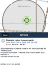
On the topic of unreasonable notam use, the turbine farms have discovered it’s easier to make a call and have a notam issued in lieu of actually fixing lights.
A ONE YEAR notam on light outages (photo).
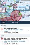
It’s almost as silly as the TFR “temporary” flight restriction of one year duration at Brownsville I posted just before. (Didn’t Disney have a many years TFR?)IMG_3470.jpeg
 
I'm also a certified UAS pilot and am involved in the Coast Guard's development of UAS technologies for our use. There was a lengthy discussion amongst our group a few months ago about ADS-B on drones in order to prevent airspace conflicts between UAS and helicopter operations in the SAR environment. Currently, our policy is that if a municipality or other government agency is operating a drone we keep our helicopters well away. This is not conducive to effective searching. This is the only environment I'm aware of where legitimate operations may conflict with each other and result in a mid-air. Nobody even considers for a moment about calling the FAA for a NOTAM when we're sending all available resources to look for a person in the water after dark.

UAS operators are limited to 400' AGL. Aviators aren't allowed to fly below 500' AGL in almost any circumstance so I really don't understand the need for the NOTAMs. Further, licensed UAS operators are instructed on the tools to determine if their operations may conflict with other aircraft operations. It's a sort of risk matrix on a map to show additional altitude restrictions, like under the approach path for a runway. But only certificated UAS operators have any idea that any of this exists. The vast majority of UAS operators whether operated recreationally or otherwise have no idea that there's even a certification process and continue to operate under the "Big Sky" mantra. Even my supervisors within the Coast Guard keep coming up with these crazy ideas about how we can utilize our UAS that violate FAA regulations.

All that to say this...the NOTAMs cluttering my EFB are utterly useless and I filter most of them out. To say nothing about the dozens of extra pages added to my briefing. The Boston TAC chart looks like it has chicken pox when all the local teams are playing at home.

Don't get me started on TFRs. I've mentioned in other threads but I'm happy Biden isn't President anymore. Politics aside, every time he came to Nantucket (which was often) all general aviation on the Cape came to a halt because of that ridiculous 30nm red circle. I'm sure our friends in Florida are experiencing the same with Trump.
 
SpaceX killed all this airspace for the entire year. That’s 525,600 minutes.
In 2025 they launched five times, from liftoff to first stage landing is ten minutes.
525,600 consumed when the actual use was 50 - over 10,000x what they actually used.
That’s plainly not right.
Even if you make allowances for all the things that might require a ‘time-cushion’.
I was curious about the little TFR north of SpaceX. I was thinking maybe it was over the water park but it appears to block out an area over the Coast Guard station there. A 6000' TFR for a Coast Guard station with no expiration? How can I get my station in on that action!? lol Tourists fly drones over my station all the time in the summer.

Seriously, though South Texas is absolutely blotted out with UAS operation areas - rightfully so in this case as they're operating up at the same levels we do.
 
Those high altitude ones are totally different and specifically for military UAS use.
 
Here in NJ last year every yahoo who's lived in the shadow of EWR all their lives suddenly looked up and noticed airplanes in the sky. Like 1% of them actually were hobbyist quadcopter drones, but most of the video I saw posted one could read the livery on the tail.

The sectionals then developed a case of acne worse than a pubescent teen -- pock-marked with little red circles of 0-400 AGL TFRs.

After the Nov '24 election everyone asked "Where did all the drones go?" I answered "To Newark Airport, like their flight plan said they would."

I thought that all went away?
 
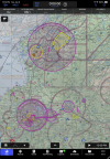
5 notamed airspace circles; 4 of them overlapping so much that the chart details are obscured! Have to turn them off to use the chart .
These are all wind turbine light outages


IMG_3530.jpeg
 
OK, so we all agree this is out of hand. Question becomes, then...who do we complain to, exactly?
 
Silly discussion. As if a thousand low level ADS-B targets on a screen will help anyone in five years.
 
Silly discussion. As if a thousand low level ADS-B targets on a screen will help anyone in five years.
No worries. Unless the regulations that prohibit the use of ADS-B in hobby drones change, that won't be a problem.
 
I was curious about the little TFR north of SpaceX. I was thinking maybe it was over the water park but it appears to block out an area over the Coast Guard station there. A 6000' TFR for a Coast Guard station with no expiration?

Every time we've been to South Padre we've notice a large balloon above the station. Didn't see an equipment package on it, but given the location we've assumed it's to detect illegal border incursions.
 
Drones should have ADSB in and software that won’t allow it to fly within a bubble around that target. Then the drone operator has no choice but to give way to the manned aircraft that can’t see the drone.
 
To be fair, we have actual airplanes out there that still operate NORDO. Until the FAA says "shall," you'll never get every plane equipped with ADS out. So the risk still exists albeit by a smaller margin.
 
Every time we've been to South Padre we've notice a large balloon above the station. Didn't see an equipment package on it, but given the location we've assumed it's to detect illegal border incursions.
Hmmm...seems likely. Lots has changed since I worked down there over 10 years ago.
 
They have a zone at my airport but it's clear of the patterns and these guys ain't small, they're all pretty big, like about 3/4 the size of a 150. They stay in an area where nobody is going to be normally.
 
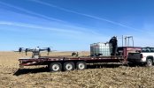
As a commercial pilot I can understand the NOTAM frustration. As an an ag producer the spray drone I use has a 10 ft wingspan. As my drone weighs 200 lbs I had to apply for a FAA exemption from several FAA regulations. My exemption requires me to file a NOTAM at least 24 hours before the flight is to take place. That doesn't work for agriculture. Spraying is very wind dependent and when the weather says spray you go spray. The work around is to issue a NOTAM that covers the whole spray season. I agree that's not helping manned aircraft but its the system we have right now.

Spray drones fly 100ft or less so the only aircraft I worry about is crop dusters. If one is working nearby I land until he is done. Would be a very bad day to have a collision.


IMG_2835.jpeg
 
Back
Top