"Position-Only Flight" on FlightAware"

dbahn

Pattern Altitude
Joined
Aug 28, 2007
Messages
1,525
Location
Vermont
Display Name

Display name:
Dave Bahnson
A few days ago I took the C206 up for a flight after its annual, then happened to check FlightAware afterwards, which showed an erroneous but continuous flight path. I departed Middlebury (6B0), flew west to check some instruments then flew towards BTV (inside class C airspace) for two touch and goes, so obviously I was in contact with ATC. After that I flew across Lake Champlain to Plattsburgh (KPBG) for another touch and go, then south to Ticonderoga for fuel before returning to MIddlebury. The route on FlightAware makes it look like I didn't even go to Plattsburgh, and the pattern at Burlington looks like I was "disoriented" in the pattern.
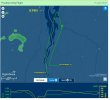
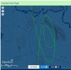
Clipboard01.jpgClipboard03.jpg

I later compared those tracks to ForeFlight when I got home, and it shows the marked discrepancy in the tracking between the two products. I can understand omitting portions of the flight path for a variety of reasons, but why does "Position-Only" show a continuous but "ficticious" course? I looked through a few other that were VFR but they showed accurate tracking and no "Position-Only" designation.
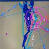
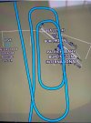

FF1.jpgFF2.jpg
 
Lack of low-level ADS-B coverage will make the track look funny.

Position-only might be explained by no filed flight plan, and probably no VFR flight-following services with ATC, so they didn't put an origin and destination in the system for you.
 
The Flightaware track of your pattern work looks reasonable, given a lower fidelity update rate and accuracy. I don't see any issue there.

The rest is likely just explained by you being at low altitude in mountainous terrain. ADS-B requires line of sight to ground receivers. In my day job, I often drop off the various trackers when we're low altitude.
 
Well, virtually all of the flight was in radar coverage well between adjacent mountains (Champlain Valley) and I did get a squawk code of course for the class C with ADS-b out capability so I'm not sure that explains it. But what seemed surprising wasn't so much the absence of track depiction as it was the presence of an uninterrupted but false track.
 
That's just how FA depicts it. It assumes you flew in a straight line between each data point. If data is missing for a prolonged period of time and you weren't flying in a straight line then the track will not be accurate.

It would have helped to figure out what was happening if you posted the track log. May be the controller entered your tail number wrong and FA is using ADS-B only.
 
Well, virtually all of the flight was in radar coverage well between adjacent mountains (Champlain Valley) and I did get a squawk code of course for the class C with ADS-b out capability so I'm not sure that explains it. But what seemed surprising wasn't so much the absence of track depiction as it was the presence of an uninterrupted but false track.
Radar coverage is not equivalent to ADS-B coverage, as ADS-B ground stations are not collocated with radar sites.

I did find the following map, which if correct shows that there are two ADS-B stations in that area. One is just south of Plattsburgh and the other is further east.

So ADS-B coverage should have been pretty good for your flight in that area. Unless, of course, the station near Plattsburgh was out of service for some reason, then given the terrain I imagine the station to the east may very well not have been receiving your position when you were down in the valley (near Plattsburgh). I can easily see that making your route look like it does.

 
Back
Top