Hi, all,
A perfectly clear morning dawned in Alaska... spring is here! It snowed last week, but today it was 60 degrees... the garage sales are out, the trees are sprouting little green leaflets, the sun is going down at 11:00pm, the farmer's market is back.... Oh Ye Gods, it is wonderful. Best of all, finals week at UAA has come and gone and I am a free woman.
Time to shake the rust off the ol' C-150 piloting skills. I was flying solo. Took off from Merrill Field and headed south, to explore Turnagain Arm. This is a fjord-like wide-but-shallow body of water cut between the mountains by glaciers, just south of Anchorage. The pictures are as follows:
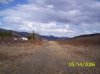
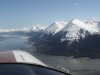
1) The "entrance" to Turnagain Arm (left side) -- down below you can see the Seward Highway which goes from Anchorage to Girdwood and Seward... This is a great "Gee, what lies around this corner?" shot.
2) The "entrance" to Turnagain Arm (right side) -- there's very little in the way of human habitation on the other side
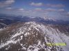
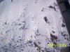
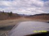
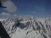
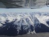
3) Mountains. A cool shot of the black/white contrasts that are emerging as the snow melts
4) More mountains. Neat reflecting light!
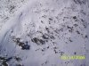
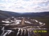
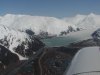
5) Portage lake and glacier. You can see how much the glacier has receded in the last 10 years... when I remember going there last, it felt as if you could practically touch the glacier from the parking lot on the near shore of the lake, even in summer. I didn't get very many other pictures of the Glacier, because I was busy planning and executing a "gemme-outta-here" turn over the lake before finding myself on the other side of narrow Portage Pass... or worse. The glacier is basically The End of Turnagain Arm; here there be big craggy rocks!
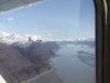
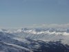
6) More mountains. More, more, more....
Most Alaskan pilots seem to consider 2000 feet to be plenty high for just about all flying. They seem to like to stay below level of the tops of the mountains on either side of whatever canyon they're flying in because it's less bumpy, but (as you can tell from the pictures) I like to fly higher. The amazing thing about flying above the mountaintop level is that you can see how incredibly VAST the mountain ranges are. Past the closest peaks, there are more peaks, and into the infinite distance there are more peaks, and more peaks, and more peaks...... they just go on and on and ON. Pictures simply cannot capture it!
I listened in on Anchorage Approach until the reception died in the canyons. But I overheard a Navion call in that he'd lost his engine. He'd run a fuel tank dry and was attempting to switch to another tank and get the engine re-started. "I might have to put down in the mud flats," he said at one point. Reception was intermittent, but I did hear him finally announce that he'd successfully gotten the engine restarted...
1.7 Hobbs.
--Kath
A perfectly clear morning dawned in Alaska... spring is here! It snowed last week, but today it was 60 degrees... the garage sales are out, the trees are sprouting little green leaflets, the sun is going down at 11:00pm, the farmer's market is back.... Oh Ye Gods, it is wonderful. Best of all, finals week at UAA has come and gone and I am a free woman.
Time to shake the rust off the ol' C-150 piloting skills. I was flying solo. Took off from Merrill Field and headed south, to explore Turnagain Arm. This is a fjord-like wide-but-shallow body of water cut between the mountains by glaciers, just south of Anchorage. The pictures are as follows:
1) The "entrance" to Turnagain Arm (left side) -- down below you can see the Seward Highway which goes from Anchorage to Girdwood and Seward... This is a great "Gee, what lies around this corner?" shot.
2) The "entrance" to Turnagain Arm (right side) -- there's very little in the way of human habitation on the other side
3) Mountains. A cool shot of the black/white contrasts that are emerging as the snow melts
4) More mountains. Neat reflecting light!
5) Portage lake and glacier. You can see how much the glacier has receded in the last 10 years... when I remember going there last, it felt as if you could practically touch the glacier from the parking lot on the near shore of the lake, even in summer. I didn't get very many other pictures of the Glacier, because I was busy planning and executing a "gemme-outta-here" turn over the lake before finding myself on the other side of narrow Portage Pass... or worse. The glacier is basically The End of Turnagain Arm; here there be big craggy rocks!
6) More mountains. More, more, more....
Most Alaskan pilots seem to consider 2000 feet to be plenty high for just about all flying. They seem to like to stay below level of the tops of the mountains on either side of whatever canyon they're flying in because it's less bumpy, but (as you can tell from the pictures) I like to fly higher. The amazing thing about flying above the mountaintop level is that you can see how incredibly VAST the mountain ranges are. Past the closest peaks, there are more peaks, and into the infinite distance there are more peaks, and more peaks, and more peaks...... they just go on and on and ON. Pictures simply cannot capture it!
I listened in on Anchorage Approach until the reception died in the canyons. But I overheard a Navion call in that he'd lost his engine. He'd run a fuel tank dry and was attempting to switch to another tank and get the engine re-started. "I might have to put down in the mud flats," he said at one point. Reception was intermittent, but I did hear him finally announce that he'd successfully gotten the engine restarted...
1.7 Hobbs.
--Kath
 That's beautiful.