Old school "visualizer/planner"

CharlieD3

En-Route
Joined
Jun 17, 2019
Messages
3,390
Location
Tennessee
Display Name

Display name:
CharlieD3
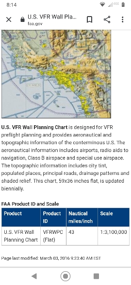
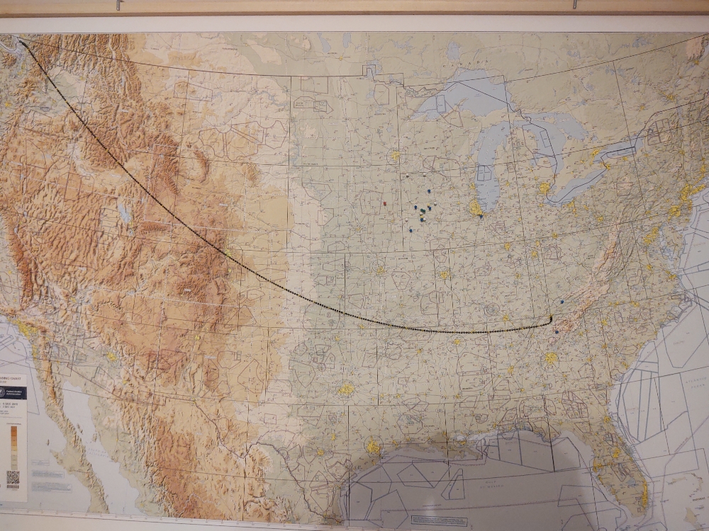
So, I posted elsewhere that I mounted and framed a US airport/airspace map.

How to do quick and dirty flight planning with one? The scale is not to any plotter standard, and a yardstick or straightedge is cumbersome...

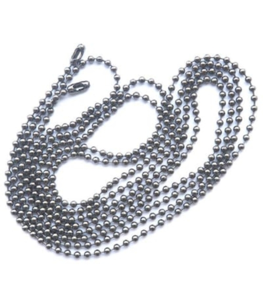
My solution? Bead chain. 72” from Lowe's.

Now, for rough planning, 6 beads= 50 nautical miles. So I painted every 6th bead dayglow yellow (leaving the coupler on the one end with a hole drilled thru it and measured against the scale for the first painted bead).

72" is long enough from east tennessee, to reach the farthest NW corner of the country. If you live in the Florida keys, you may need more than one chain.

I think it's simple, elegant, and if I ever fly more than a hundred miles, it might even be useful.

Don't know where else to put this post.
8bf40e5913003e87db1ca7936d2e9f2c.jpg
fa1e01da3c09a76082770a43fb091c6d.jpg
 
I have a map like this in my hangar, with a pin marking each airport I've taken the Bonanza to.
It's easy to forget how large this country really is if you just look at it though the screen of an iPad.

- Martin
 
I have a map like this in my hangar, with a pin marking each airport I've taken the Bonanza to.
It's easy to forget how large this country really is if you just look at it though the screen of an iPad.

- Martin
The relative few pins I have in mine are green for home 'dromes (3 now), white for solo, blue for with pax. Red for... Aborted landing.
 
I have a map like this in my hangar, with a pin marking each airport I've taken the Bonanza to.
It's easy to forget how large this country really is if you just look at it though the screen of an iPad.

- Martin
Similarly, it's easy to forget how far you can go in an airplane if you don't have some kind of map like this to see that your pins really are spread out across a huge territory. Every time I look at the "visited" page in MyFlightBook, I am a little bit impressed that I covered so much territory with slow airplanes like my Arrow.
 
Similarly, it's easy to forget how far you can go in an airplane if you don't have some kind of map like this to see that your pins really are spread out across a huge territory. Every time I look at the "visited" page in MyFlightBook, I am a little bit impressed that I covered so much territory with slow airplanes like my Arrow.

Yeah, that's next... Transferring all my logbook entries into MyFlightBook.... To have a digital record... But I like the permanence of the wall map, too.

I'm a bit of a luddite...
 
Someone did this with one of those retractable clotheslines at a flight school here once. Drilled a small hole and ran it through from behind and put a little bead on the end.

Then marked the cotton string in some increments — I forget how far between each.
 
I did similar, but with a white string that I marked in 100nm increments with red sharpie. That string is anchored at my home field and is long enough to reach anywhere on the map.

I also marked airports I’ve been to with red post-it tabs that I cut into thin strips, and airports that I want to fly to with blue ones.
 
That's pretty cool. The beads describe a catenary curve, but when placed on an Albers or Lambert projection probably not a Great Circle route. So your beads will likely take you out of your way if you really follow them for long trips.
 
Hey - I remember this kind of map when I was a kid. It was at my small town airport. As a 10 year old couldn't understand why a map of the US had so many strange colors, blocks, etc.
 
That's pretty cool. The beads describe a catenary curve, but when placed on an Albers or Lambert projection probably not a Great Circle route. So your beads will likely take you out of your way if you really follow them for long trips.
I think the map is "flattened" the bead measurement above from TN98 to LAS is a taut measurement. It was only 9NM short, in 1500NM. Wouldn't a great circle route be more of a difference?
 
I think the map is "flattened" the bead measurement above from TN98 to LAS is a taut measurement. It was only 9NM short, in 1500NM. Wouldn't a great circle route be more of a difference?

Whether or not the “straight” line of the chain or string depicts something akin to a Great Circle depends on the projection type of the map itself.

With that likely being Mercator and within the distances of the continent, the string thing is going to be close enough for rock and roll generally.

Most of the EFB flight planners do true great circles for direct routings. And you’ll be breaking all that up into legs with tighter planning anyway over the really big distances.

I think the coolest thing to come along for “fun wall planning” and dreaming about trips are the projects that take the weather forecasts or METARs and turn them into driving the colored LED pixels on a wall map. Combine the two would be fun.

Someone could get really fancy and make one out of a giant touchscreen. Tap on where you want to go and get a line and a distance and weather along the route and at the destination...

But the simplicity of a paper map and a string sometimes feels different. Too much tech. Let the brain do some imagining. Pull the string to someplace random and imagine the whole flight. See what’s along the way. Stuff like that.

I like maps. I should hang more of them up at home. They’re art.

:) :) :)

Great minds and all that....


I mean, EFBs are cool toys; slick and even "free" (donation based) EFBs like Avare work a treat compared to the old plotter, whiz wheel, FSS in person or phone briefing, circling water towers to make sure you're on course, and dead reckoning days of my past...

There's still something sensual/tactile about a map or chart...

And I do think the METAR maps are a marriage of both worlds, too.
 
The problem is that the FAA no longer makes the IFR/VFR planning wall chart and hasn't for nearly two decades. This is the problem with the way the FAA does it's limited current user fees, and doesn't bode well for what happens if they get more things allegedly financed by them.
 
The problem is that the FAA no longer makes the IFR/VFR planning wall chart and hasn't for nearly two decades. This is the problem with the way the FAA does it's limited current user fees, and doesn't bode well for what happens if they get more things allegedly financed by them.
Found this (see screenshot below) on FAA site. Updated biennially.

Bought mine from mypilotstore.

The FAA site has the pdf... Take to any large format print shop....

<Edit to add... I see you said IFR/VFR...>
ba24757858e363418fa5e3a78536f76c.jpg
 
Last edited:
That's NOT the same chart. That one unfolds to about the size of a sectional. The VFR/IFR chart was about 6 feet tall and 8 feet wide.
 
That's NOT the same chart. That one unfolds to about the size of a sectional. The VFR/IFR chart was about 6 feet tall and 8 feet wide.
Yep, I was correcting editing my post when you posted this... Ooops.
 
Is this the one?
dcc71235e033a0a0d91c9b9c48f083ba.jpg

Nope. Again, that's the "flight bag" (I.E., sectional size, 40x36"). The FAA has not produced the wall version for decades.

The problem is when the FAA sells a chart, the money for the sale does NOT go back to the FAA to defray the production of the chart, but rather it goes into the general fund.
The FAA "makes" money by producing the bare minimum of charts that they can get away with.
 
I'm talking about the VFR wall planning chart, under the Planning tab.
 
That's a 5' x 3' chart. Yeah, you could print it larger, but you're losing detail. It's not the old IFR/VFR wall chart.
I might be wrong... But I think pdf is scalable... If not, scaling 200% would be crappy.
 
Back
Top