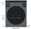
New Traffic display for ADSB-In devices

swedeflyer

Filing Flight Plan
Joined
May 28, 2014
Messages
28
Display Name

Display name:
SwedeFlyer
I Need some of you guys to try out a new Traffic display (Android only) for ADSB-In devices (Wifi only).
I developed an Android App (called TrafficAssist) that closely follows the TCAS II protocol and displays the data as you would see it in a
commercial aircraft. TrafficAssist will display Traffic Advisories as well as Resolution Advisories. Features are selectable via Preferences.
In addition to display the traffic it will identify Make/Model of aircraft as long as is in the US or Canadian registry.

So if you have the following ADSB-In devices:

Stratus (Open ADSB Mode GDL90 protocol)
Stratux
OpenFlightSystems (Stratux)
Dynon SV-ADSB-472 (Using the Dynon WI-FI ADAPTER FOR SKYVIEW)
uAvionix echoUat
... and other ones that support the GDL90 format using Wifi

As you well know for ADSB traffic to work properly you need the ADSB-Out
feature as well.
So I am looking for feedback and improvements. As a thank you will receive the final product free of charge.
Interested, shoot me an e-mail at: swedeflyer@gmail.com
I will give you more details after you contact me.


Peter
 
Haven't looked at the app, as for power flying pretty much exclusively use IOS, and the glider already has a Traffic In device and display (Flarm).

I love the Idea of a dedicated traffic app that I can run on my phone along side my ipad.
Better still would be audio warning (visual too if possible) of any traffic with one mile and 500 feet and getting closer (or other selectable parameters)

Lack of a warning of closing traffic is my biggest complaint about most traffic displays. Or to many warnings about traffic that isn't an issue.

Brian
CFIIG/ASEL
 
Email inbound; Startux / Android EFB user.
 
I find ADSB to be unreliable…..some targets my 1090Es gets when the iPad doesn’t and other times I have traffic on the iPad (978) that doesn’t show on the transponder.

im not seeing consistent targets.
 
Haven't looked at the app, as for power flying pretty much exclusively use IOS, and the glider already has a Traffic In device and display (Flarm).

I love the Idea of a dedicated traffic app that I can run on my phone along side my ipad.
Better still would be audio warning (visual too if possible) of any traffic with one mile and 500 feet and getting closer (or other selectable parameters)

Lack of a warning of closing traffic is my biggest complaint about most traffic displays. Or to many warnings about traffic that isn't an issue.

Brian
CFIIG/ASEL
I believe I am addressing some of your issues. My approach is to mimic the TCAS II specifications, this is what you see in any modern commercial aircraft be it a Boeing 777 or an Airbus 3XX series.
Peter
 
I find ADSB to be unreliable…..some targets my 1090Es gets when the iPad doesn’t and other times I have traffic on the iPad (978) that doesn’t show on the transponder.

im not seeing consistent targets.
ADSB should be reliable, (I have used it for several years now). It might be (not sure though) that the applications are not clear enough or maybe loosing data.
Like I said in my original post, I am looking for a few fine folks to try this app a hands-off TCAS type display.
Peter
 
My approach is to mimic the TCAS II specifications, this is what you see in any modern commercial aircraft be it a Boeing 777 or an Airbus 3XX series.
Let me make sure I don't misunderstand: are you issuing RAs (resolution advisories) just based on ADS-B data?
If so, how are you avoiding guidance that could be in conflict with what the other airplane's TCAS is telling their pilots?
RAs are great when two TCAS systems talk to each other. If not, isn't it like playing Russian roulette?

Regards,
Martin
Martin,

You're absolutely correct, obviously a passive ADSB solution does not have this capability (TCASII). Currently TCAS II spec only has 3 types of advisories:
1. Climb, Climb (Sometimes more than 2000ft/min
2. Descend, Descend (Sometimes more than 2000ft/min
3. remain level

Now for GA this may be impractical, and maybe the RA announcement should not be there in the App. Right now I have it as a preference item.
I also looked at the TCASIII spec, which was abandoned by the FAA, where lateral avoidance maneuvers were announced.
Russian roulette --- not really, obviously your head needs to be outside the cockpit, this display may guide you to where to look.
Anyway, I have used ADSB with Traffic displayed on Moving maps for a few years now, amazing stuff, really. However when I look at the cockpits of the big iron (777 or A350) and others their main displays are 1. Flight Director, 2. TCAS
So my effort is to make a clear uncluttered TCAS display.
Thanks for your input...
Peter
 
Screenshot would be cool, if you don't mind sharing.
Sure no problem.
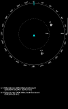
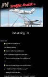
One is showing the Initialization screen with ADSB and all available GPS resources initializing
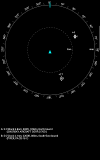
The other one is an example of Traffic, You see an example of Proximate Traffic (A Sikorsky S76 Helicopter) The other one is Other Traffic (A Piper PA28)
Now the nomenclature as to the icons.
Other Traffic (Outlined Diamond)
Proximate Traffic (Filled White Diamond)
Traffic Alert (Filled Amber/Yellow Circle)
Resolution Advisory (Filled Red Square)
are described in the TCASII specifications.

As pointed out earlier I do NOT give out Resolution Advisories as this is a Passive System relying solely on ADSB-In transmissions.
However I use the icons described.

Screenshot_20230927_112725.png Screenshot_20231008-075137_Traffic Assist.jpg
 
Sure no problem.
One is showing the Initialization screen with ADSB and all available GPS resources initializing
The other one is an example of Traffic, You see an example of Proximate Traffic (A Sikorsky S76 Helicopter) The other one is Other Traffic (A Piper PA28)
Now the nomenclature as to the icons.
Other Traffic (Outlined Diamond)
Proximate Traffic (Filled White Diamond)
Traffic Alert (Filled Amber/Yellow Circle)
Resolution Advisory (Filled Red Square)
are described in the TCASII specifications.

As pointed out earlier I do NOT give out Resolution Advisories as this is a Passive System relying solely on ADSB-In transmissions.
However I use the icons described.

View attachment 121227 View attachment 121226
Looks cool. Simple and uncluttered.
 
Not sure it's better enough to give-up similar looking Foreflight's traffic alert or Garmin TargetTrend. Rather not have to switch apps for a specific task when the one already in use is nearly the same.

At least for me, greatly prefer to see possible conflicting traffic alerts on the same software already using for navigation. Maybe I'm missing something here?
 
I’m happy with foreflight as I’m not android capable.
 
Not sure it's better enough to give-up similar looking Foreflight's traffic alert or Garmin TargetTrend. Rather not have to switch apps for a specific task when the one already in use is nearly the same.

At least for me, greatly prefer to see possible conflicting traffic alerts on the same software already using for navigation. Maybe I'm missing something here?
No you're not missing anything. That's the beauty, you have a choice, if you're happy with it, stick to it.
Now one might ask why another App for this?
My issue with them is that they are superimposing traffic on a VFR type map, that gives you further clutter. Sometimes it's hard to discern the Traffic.
Now when you look at the Big guys i.e. Boeing Airbus, they all have a very simple setup, take a look at their cockpits, Main displays are Flight Director and next to it is the TCAS, the TCAS also has Weather superimposed on it (Next version...).
So, the idea is to have an easy to interpret display which requires no User Interaction and that gives you a heads up on Traffic. To have this using a $100 Samsung Tablet and a $400 Stratux is a pretty good deal don't you think?? Also there is no reason to give up your favorite Moving Map, this data is broadcast over UDP on Wifi.
Swedeflyer
$400 Stratux? That seems pretty high. Raspberry Pi's are now available again at reasonable prices ($35 & $45). A DIY Stratux is still <$200.
 
$400 Stratux? That seems pretty high. Raspberry Pi's are now available again at reasonable prices ($35 & $45). A DIY Stratux is still <$200.
So https://crewdogelectronics.com/ makes a good profit. BTW this is with the outside antenna as well as AHRS and Battery. I don't think you can do all of that for under $200. More to my point.
Swedeflyer
 
So https://crewdogelectronics.com/ makes a good profit. BTW this is with the outside antenna as well as AHRS and Battery. I don't think you can do all of that for under $200. More to my point.
Swedeflyer
BTW
<<<<<<<<<<<<<<<>>>>>>>>>>>>>>>>>>>>>>>>
How much does a TCAS system cost?
between $25,000 and $150,000
TCAS is not fitted to many smaller aircraft mainly due to the high costs involved (between $25,000 and $150,000).
<<<<<<<<<<<<<<<>>>>>>>>>>>>>>>>>>>>>>>>
For Example the Garmin GTS 8000
is $59,900 USD
 
So my effort is to make a clear uncluttered ... display.

Now one might ask why another App for this?
My issue with them is that they are superimposing traffic on a VFR type map, that gives you further clutter.
Sometimes it's hard to discern the Traffic.

Thanks Peter,
Displaying traffic on a VFR map (or IFR enroute charts, etc) is not the only way to show traffic in existing applications.
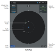
For example, it's not difficult to discern traffic using dedicated "Traffic" page.

It appears difference between Garmin Pilot (for example) and 'Traffic Assist' is: your app lists 'aircraft type'; (A) and (B) in this illustration.

Traffic Assist

1696804904008.png

versus
Garmin Pilot
- Traffic page

1696806824330.png1696807075883.png
© Garmin Pilot for Android (Rev Z, Aug 2023)

Agree with @NordicDave.
Seems easier to use existing apps for Traffic (Garmin Pilot, etc), and without need for an additional app.

Hope the requested feedback is useful.
 
Last edited:
Thanks for your feedback. Yes it is useful, thank you.
Two things:
1. Not everyone uses Foreflight.
2. The Type and Model is just for US and Canadian registered aircraft, I could extend it, I guess, but it helps to spot the target. This could probably be improved
3. Yes I have some other gems in this App such as adhering to the TCAS II alert levels, so check out TCAS II:
check out this link for more information
https://www.faa.gov/documentlibrary/media/advisory_circular/tcas%20ii%20v7.1%20intro%20booklet.pdf
Peter
 
Thanks Peter,
Displaying traffic on a VFR map (or IFR enroute charts, etc) is not the only way to show traffic in existing applications.
For example, it's not difficult to discern traffic using dedicated "Traffic" page.

It appears difference between Garmin Pilot (for example) and 'Traffic Assist' is: your app lists 'aircraft type'; (A) and (B) in this illustration.

Traffic Assist

View attachment 121236

versus
Garmin Pilot
- Traffic page

View attachment 121239View attachment 121240
© Garmin Pilot for Android (Rev Z, Aug 2023)

Agree with @NordicDave.
Seems easier to use existing apps for Traffic (Garmin Pilot, etc), and without need for an additional app.

Hope the requested feedback is useful.
It seems that Garmin Pilot is not adhering to TCASII icon usage could be wrong on this one.
Check out this booklet:
https://www.faa.gov/documentlibrary/media/advisory_circular/tcas%20ii%20v7.1%20intro%20booklet.pdf
Peter
 
Sure no problem.
One is showing the Initialization screen with ADSB and all available GPS resources initializing
The other one is an example of Traffic, You see an example of Proximate Traffic (A Sikorsky S76 Helicopter) The other one is Other Traffic (A Piper PA28)
Now the nomenclature as to the icons.
Other Traffic (Outlined Diamond)
Proximate Traffic (Filled White Diamond)
Traffic Alert (Filled Amber/Yellow Circle)
Resolution Advisory (Filled Red Square)
are described in the TCASII specifications.

As pointed out earlier I do NOT give out Resolution Advisories as this is a Passive System relying solely on ADSB-In transmissions.
However I use the icons described.

View attachment 121227 View attachment 121226

I've always wanted an in cockpit display that would distinguish between piston/jet/helicopter. The FAA database has the information and it is tied to the mode-s codes. You could change the traffic icons
 
So https://crewdogelectronics.com/ makes a good profit. BTW this is with the outside antenna as well as AHRS and Battery. I don't think you can do all of that for under $200. More to my point.
Swedeflyer
Yep. Probably a bit over $200, after all. $170 for the kit that includes case, GPS, AHRS, fan, antennas, SDRs heatsinks. $45 for Rasberry Pi, & $30 for power bank. Still less than $250 for the DIY'er. I was an early adopter and I'd hate to add up how much I've spent since 2015 on all the iterations, but it's still possible to get ADSB-IN for a song if you don't mind the DIY route.
-------

Your display is similar to what I always wanted for Stratux. I don't have the time/skill to do the programming, but I always thought it would be a useful option to create an add-on display to the stratux itself so that it would be a single unit traffic display, all in one box. I suggested that as an option way back when. Your solution is the closest to that vision that I've seen. I may have to buy an android tablet just to try it out.
 
I've always wanted an in cockpit display that would distinguish between piston/jet/helicopter. The FAA database has the information and it is tied to the mode-s codes. You could change the traffic icons
I thought about that as well, Maybe as an alternative to the TCASII icons (Diamonds, squares and circles oh, my) I could have icons depicting the real aircrafts that's heading your way. That would be cool... right
 
Yep. Probably a bit over $200, after all. $170 for the kit that includes case, GPS, AHRS, fan, antennas, SDRs heatsinks. $45 for Rasberry Pi, & $30 for power bank. Still less than $250 for the DIY'er. I was an early adopter and I'd hate to add up how much I've spent since 2015 on all the iterations, but it's still possible to get ADSB-IN for a song if you don't mind the DIY route.
-------

Your display is similar to what I always wanted for Stratux. I don't have the time/skill to do the programming, but I always thought it would be a useful option to create an add-on display to the stratux itself so that it would be a single unit traffic display, all in one box. I suggested that as an option way back when. Your solution is the closest to that vision that I've seen. I may have to buy an android tablet just to try it out.
I think you should if you're interested shoot me an email swedeflyer@gmail.com
 
I think you should if you're interested shoot me an email swedeflyer@gmail.com
Yep. Probably a bit over $200, after all. $170 for the kit that includes case, GPS, AHRS, fan, antennas, SDRs heatsinks. $45 for Rasberry Pi, & $30 for power bank. Still less than $250 for the DIY'er. I was an early adopter and I'd hate to add up how much I've spent since 2015 on all the iterations, but it's still possible to get ADSB-IN for a song if you don't mind the DIY route.
-------

Your display is similar to what I always wanted for Stratux. I don't have the time/skill to do the programming, but I always thought it would be a useful option to create an add-on display to the stratux itself so that it would be a single unit traffic display, all in one box. I suggested that as an option way back when. Your solution is the closest to that vision that I've seen. I may have to buy an android tablet just to try it out.
Remember that Android phones will also work (Samsung, Motorola, LG etc), of course the size might be an issue.
 
Input from a sentry possible?

I definitely see the advantage for people who don’t have a big screen in dash.
 
I have always desired a dedicated traffic display for my Adsb traffic that was inexpensive. What I have done is use the capability of my IPad and IPhone with FlyQ in conjunction with Stratux. There is an option to select only traffic in a forward moving display with an uncluttered background showing essentially only land and water in dark green and ?black? respectively. Even if one selects the digital layer option, it is still remarkably without clutter to discern traffic targets easily. I had used one of my old IPhones with a ram mount only for the traffic as above, and also have the traffic appear on my IPad on my lap. I got tired of having to deal with both devices and their real-time flying charging concerns. So, what I do most often is utilize my lap IPad using FlyQ in split screen mode where the left side is Low Alt IFR or VFR moving map, while my right half has the uncluttered dedicated traffic as described above. Obviously, if you have additional iPads or IPhones that dimensionally meet your needs, fixing it with Velcro to your panel instead of a mount would also be an option if you are satisfied with a method to keep that display energized. Because a 15 nm traffic ring is also available,which can be zoomed in or out, scaling becomes evident for immediately traffic concerns.
 
TrafficAssist is released check a separate post
 
Back
Top