New IAPs at KMMU

midlifeflyer

Touchdown! Greaser!
PoA Supporter
Joined
May 25, 2006
Messages
22,000
Location
KTTA, North Carolina
Display Name
Who you kiddin?
Home Airfield
KTTA
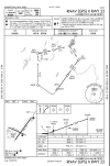
The newest update includes new ILS or LOC Y and RNAV (GPS) X approaches at Morristown Municipal in New Jersey. In addition to the famous BADDA - BINGG sequence on the extended final approach segment, there is a brand new waypoint on the missed.
1764621493247.png
 
The newest update includes new ILS or LOC Y and RNAV (GPS) X approaches at Morristown Municipal in New Jersey. In addition to the famous BADDA - BINGG sequence on the extended final approach segment, there is a brand new waypoint on the missed.
View attachment 147723
The Z missed went out yonder to SBJ. The new Y keeps things in closer but has minimum climb and airspeed requirement. Not very restrictive though except the airspeed one if you flying a hot rod. Thing I don’t get is, if I’m reading it right, GPS is required, so why is BADDA an Intersection/Radar Fix instead of a Waypoint.
 
The current POTUS received a medical deferment during the Vietnam War for bone spurs in his heels. That fix is in the direction of where he spends time in the summer.
Do me a favor and delete this for now while we talk about the Approaches for awhile then bring that up later so the thread don’t get locked now.
 
The Z missed went out yonder to SBJ. The new Y keeps things in closer but has minimum climb and airspeed requirement. Not very restrictive though except the airspeed one if you flying a hot rod. Thing I don’t get is, if I’m reading it right, GPS is required, so why is BADDA an Intersection/Radar Fix instead of a Waypoint.
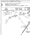
I'm guessing because it pre-dates RNAV for the ILS and is identifiable off the SAX R-151. You'll notice from the ILS Z that neither GPS nor RADAR are required for that segment of the approach.
1764690323153.png
 
The current POTUS received a medical deferment during the Vietnam War for bone spurs in his heels. That fix is in the direction of where he spends time in the summer.
More likely to avoid that direction - to keep people out of the Bedminster TFR when it is active. The original fix is SBJ VOR which is in the heart of the TFR area.
 
I'm guessing because it pre-dates RNAV for the ILS and is identifiable off the SAX R-151. You'll notice from the ILS Z that neither GPS nor RADAR are required for that segment of the approach.
View attachment 147753
Yeah, the Z specifies particular fixes GPS is required for, the Y has a blanket GPS required for the Approach. Ain’t no thang at the end of the day to fly the Approach but I wonder why. Maybe an oversight or maybe a change in rules how things are displayed between the dates of the approaches. @RussR , when you have some time…
 
More likely to avoid that direction - to keep people out of the Bedminster TFR when it is active. The original fix is SBJ VOR which is in the heart of the TFR area.
Somebody, that would be the somebody what be the one what picks names for fixes, may have some ‘splainin to do.
 
Yeah, the Z specifies particular fixes GPS is required for, the Y has a blanket GPS required for the Approach. Ain’t no thang at the end of the day to fly the Approach but I wonder why. Maybe an oversight or maybe a change in rules how things are displayed between the dates of the approaches. @RussR , when you have some time…
I'm guessing because the Y has not only the initial approach segments from EMRSN, but the missed to the new BSPUR is solely based on GPS. That makes the FAC the only segment using ground-based navaids.
 
Yeah, the Z specifies particular fixes GPS is required for, the Y has a blanket GPS required for the Approach. Ain’t no thang at the end of the day to fly the Approach but I wonder why. Maybe an oversight or maybe a change in rules how things are displayed between the dates of the approaches. @RussR , when you have some time…
Sometimes I enjoy being called upon for these types of questions.

This is not one of those times.

There are a lot of inconsistencies in the charting and notes on these new things like RNAV transitions to ILS. A lot of it has to do when the procedures were published, regarding changing criteria and policies as these things are published and actually get flown and the resultant feedback. But also, a lot has to do with the rules for some of the forms and the charts themselves being still based on the status quo of 30 or 40 years ago. With confusing rules, sometimes the application is inconsistent.

I agree, for the Z you could be vectored to final without having a GPS onboard - so you'd need the intersections and (theoretically) the VOR-based missed approach.

For the Y, since you need GPS for the missed approach, you need it to start the procedure as well - since a clearance for the approach includes a clearance for the published missed approach, especially in the event of a comm failure on final. So having the fixes identified as intersections doesn't make much sense, if you had GPS anyway, why would you stop using it?

Here's an example of what drives the charting of a fix. This information is on the Form 8260-2, every fix has one and you can access them publically by googling for "8260-2". Enter the name of the fix, and then (usually) you'll want to pick the highest number revision.

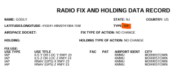
For the fix "GODLY", it is identified as a WP, Waypoint, only, and is used on 4 procedures. Easy for the charting people, they chart it using the RNAV waypoint symbol on all those procedures.

1764725781142.png

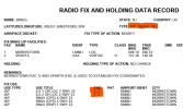
For the fix "BINGG", it is shown as a WP, Intersection, and Radar fix (DME is another option here, but not for this fix). The Fix Use field is what tells the charting agency how to chart it. So for the RNAV procedures, it will just be charted as a WP. But for the ILS procedures it will be charted as an intersection of Facilities 1 and 2. (And RADAR is added as well.)

1764725973620.png

That little "1,2" is the whole reason that the intersection is shown on the Y.

What I DON'T know, because I'm no longer on that side of the street, is whether that "1,2" was included because it's policy on a non-RNAV procedure, whether it was done for consistency with the Z, whether the form developer did it by mistake (either due to misunderstanding the rules or an oversight), or some other reason. Heck, it could even be a system limitation with the software that generates the forms (the forms are not hand-typed, there is separate software with drop-down boxes and all kinds of automatic linking and such).

I don't know.

 
Sometimes I enjoy being called upon for these types of questions.

This is not one of those times.

There are a lot of inconsistencies in the charting and notes on these new things like RNAV transitions to ILS. A lot of it has to do when the procedures were published, regarding changing criteria and policies as these things are published and actually get flown and the resultant feedback. But also, a lot has to do with the rules for some of the forms and the charts themselves being still based on the status quo of 30 or 40 years ago. With confusing rules, sometimes the application is inconsistent.

I agree, for the Z you could be vectored to final without having a GPS onboard - so you'd need the intersections and (theoretically) the VOR-based missed approach.

For the Y, since you need GPS for the missed approach, you need it to start the procedure as well - since a clearance for the approach includes a clearance for the published missed approach, especially in the event of a comm failure on final. So having the fixes identified as intersections doesn't make much sense, if you had GPS anyway, why would you stop using it?

Here's an example of what drives the charting of a fix. This information is on the Form 8260-2, every fix has one and you can access them publically by googling for "8260-2". Enter the name of the fix, and then (usually) you'll want to pick the highest number revision.

For the fix "GODLY", it is identified as a WP, Waypoint, only, and is used on 4 procedures. Easy for the charting people, they chart it using the RNAV waypoint symbol on all those procedures.

View attachment 147774

For the fix "BINGG", it is shown as a WP, Intersection, and Radar fix (DME is another option here, but not for this fix). The Fix Use field is what tells the charting agency how to chart it. So for the RNAV procedures, it will just be charted as a WP. But for the ILS procedures it will be charted as an intersection of Facilities 1 and 2. (And RADAR is added as well.)

View attachment 147775

That little "1,2" is the whole reason that the intersection is shown on the Y.

What I DON'T know, because I'm no longer on that side of the street, is whether that "1,2" was included because it's policy on a non-RNAV procedure, whether it was done for consistency with the Z, whether the form developer did it by mistake (either due to misunderstanding the rules or an oversight), or some other reason. Heck, it could even be a system limitation with the software that generates the forms (the forms are not hand-typed, there is separate software with drop-down boxes and all kinds of automatic linking and such).

I don't know.
Thanks for taking the time.
 
Back
Top