MD369FF down Pinal County - 4 dead

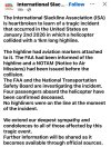
Preliminary evidence indicates a recreational slackline more than a kilometer long had been strung across the mountain range. An eyewitness who called 911 reported seeing the helicopter strike a portion of the line before falling to the bottom of the canyon
That's truly awful. I assume that stringing a line like that would have at least some kind of visibility/notification requirement for aircraft a la powerlines. Not sure if the folks who did it would face charges (negligent homicide?) or just have to live with the knowledge that their actions killed four people. Either way, I hope it raises awareness of the potential dangers of placing a slack line in such a position, and changes practice (some kind of visibility, NOTAM warning, etc.) to be safer.

In fairness, perhaps the idea of a helicopter hitting the line didn't occur to anyone. Would be interesting to know if this is a routine practice (of which pilots should be aware) or a one-off line of usual length and placement.

Either way, RIP to all on-board.
 
I saw another article that said there was a NOTAM but I haven’t actually seen it. Definitely a horrific one.
 
Either way, I hope it raises awareness of the potential dangers of placing a slack line in such a position, and changes practice (some kind of visibility, NOTAM warning, etc.) to be safer.
Unfortunately, I doubt it as people have been stretching wires and cables across rivers, canyons, etc for many years. Its the reason not to fly low over these areas whther in a helicopter or airplane. Be interesting what elevation this line was at when hit. But yes, there are laws/rules about these installations in most areas, so its quite possible someone will own this tragedy.
 
Unfortunately, I doubt it as people have been stretching wires and cables across rivers, canyons, etc for many years.
Indeed! Back when I had the privilege of occasionally flying MH-60s through the mountains of Japan, I used to wonder how effective the wire-cutters would be for the various lines strung across the valleys. Presumably a nylon(?) rope would be cut more easily. Do civilian helicopters routinely have wire-cutters installed? I presume this would be standard safety equipment.
 
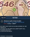
NOTAM #: 12/234
Class: Obstruction
Status: Active
Issue Date UTC: 12/21/2025 1625
Start Date UTC: 12/26/2025 1400
End Date UTC: 01/06/2026 0200
!PRC 12/234 E81 OBST TIGHT ROPE WI AN AREA DEFINED AS 1NM RADIUS OF 331412N1110714W (3NM S E81) 2800FT (600FT AGL) FLAGGED AND LGTD 2512261400-2601060200
 
NOTAM #: 01/016
Class: Obstruction
Status: Active
Issue Date UTC: 01/02/2026 2106
Start Date UTC: 01/02/2026 2106
End Date UTC: 01/09/2026 2359
!PRC 01/016 E81 OBST CABLE (ASN UNKNOWN) 331416.4N1110703.2 (2.8NM SE E81) UNKNOWN (400FT AGL) NOT LGTD 2601022106-2601092359
 
We've got two sets of high tension power lines crossing the lake near my house. One is on fairly large towers that you can see at a distance. The other is on sets of somewhat lower wires with towers that barely poke out of the trees on the shoreline. We don have seaplanes that operate on the lake, and we've been trying to get Duke to put balls on them. After a plane snagged them (albeit it was a dumbass Bonanza pilot flying between two airports on the lake just above the water), you would think they would have put markers on them when they restrung them... nope. That would be admitting that these were a hazard.
 
Do Notams such as what existed make there way onto helicopter charts on services like foreflight?
 
Do civilian helicopters routinely have wire-cutters installed?
Yes, but it usually depends on the type of operation. For example, EMS or LEO helicopters rend to have them but helicopters that fly offshore in the Gulf dont.

However, even with a WSPS kit installed any interaction with a wire tends to be a bit violent provided the wire makes it to the cutter. Regardless, if the above NOTAMs pertain to that obstacle then it pretty much points to one direction on the reason why.
 
Fell to the bottom of the canyon? What a horrifying last minute these people endured. Just awful. May they rest in peace.
 
Never heard of "slacklining" before this- had to look it up.
I didn't know that being a Nick Wallenda wannabe was a thing...
Some reason it couldn't be lower than 600'AGL where it's an obvious danger to aviation?
 
Never heard of "slacklining" before this- had to look it up.
I didn't know that being a Nick Wallenda wannabe was a thing...
Some reason it couldn't be lower than 600'AGL where it's an obvious danger to aviation?
The height of the two end points and the line tension requirements? Pilots and the public share a lot of recreational spaces. They put up a NOTAM and I expect the pilot didn’t look at it. One of his friends commented that he had flown this route a hundred times. Complacency and familiarity really get people in trouble at the best and dead in this case. I’d also argue that bombing up a canyon at 600 feet AGL in a whirlybird isn’t particularly good decision making for a pilot but I trend to safety first and thrill seeking last.
 
Some reason it couldn't be lower than 600'AGL where it's an obvious danger to aviation?

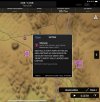
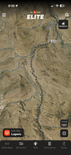
The line spanned a canyon. Top of the east side of the canyon is 3400' msl. Canyon floor is 2800' msl. Here's a screenshot with the topo for roughly the center of the notam. They were flying in a canyon. If they put the line lower they're not going to get the distance they wanted. The whole area is national forest...public land. Land or air, it's all public use and at first glance it appears the organization did what they should have to prevent this exact thing.

IMG_2927.png
 
Some reason it couldn't be lower than 600'AGL where it's an obvious danger to aviation?
I wouldn't necessarily say that anything at 600' AGL far away from an airport is an "obvious" danger to aviation. But I guess when you're flying at 600' AGL, below the nearby terrain, there are a lot of threats to aviation.
 
The whole area is national forest...public land. Land or air, it's all public use and at first glance it appears the organization did what they should have to prevent this exact thing.
Unfortunately the organization's lack of familiarity with the NOTAM system and how to make their submission more visible to pilots in the area was inadequate to protect the victims. But they made the effort, and the crash is just one of those occurrences where circumstances and fate joined to produce a tragic outcome.
 
Unfortunately the organization's lack of familiarity with the NOTAM system and how to make their submission more visible to pilots in the area was inadequate to protect the victims. But they made the effort, and the crash is just one of those occurrences where circumstances and fate joined to produce a tragic outcome.
Did the pilot obtain a briefing before the flight?
 
Unfortunately the organization's lack of familiarity with the NOTAM system and how to make their submission more visible to pilots in the area was inadequate to protect the victims. But they made the effort, and the crash is just one of those occurrences where circumstances and fate joined to produce a tragic outcome.
The NOTAM system is broken. The existence of the line is a safety-of-flight issue, and the current system will drown it in meaningless drivel.
 
The NOTAM system is broken. The existence of the line is a safety-of-flight issue, and the current system will drown it in meaningless drivel.
QFT. Flying near the SFRA, I have requested briefs via the EFB and it has been over 100 pages. That's ridiculous.

That said, modern EFBs (especially GP, in my experience) do a superb job of graphically displaying pertinent NOTAMs. I understand that some people choose not to fly with an iPad or other device, but there really isn't much excuse to not use these systems for flight planning. I was originally a bit outraged that people could just string a line like this across a valley (doubtless recording it and themselves from every possible angle with various cameras). However, it looks as though they did due diligence with notification and (apparently) visual markers. No idea whether this pilot was using an EFB for NOTAM awareness, but it may have made the difference if he didn't.
 
The NOTAM system is broken. The existence of the line is a safety-of-flight issue, and the current system will drown it in meaningless drivel.

It was a NOTAM that was only very important for 0.01% of pilots flying in the area that day, the guy that was flying down in the canyon.

That being said, let's be honest with ourselves , how many get a full briefing and review every single one of the NOTAMs for a day VFR local flight in a familiar area?

That is why the NOTAM system doesnt work. Way too many NOTAMs filed as a CYA for any reasonable pilot to be able to find the one that may or may not make a difference.
 
That being said, let's be honest with ourselves , how many get a full briefing and review every single one of the NOTAMs for a day VFR local flight in a familiar area?
That's the beauty of EFB graphical NOTAMs though. They literally just pop up on the map, so it's obvious when there is an applicable NOTAM either in effect or in the near future. There's no necessity for a full briefing just to see NOTAMs in and around where you're flying. One touch of the screen and you get the NOTAM synopsis. It's magic compared to what we used to have to get from a verbal briefing.
 
That's the beauty of EFB graphical NOTAMs though. They literally just pop up on the map, so it's obvious when there is an applicable NOTAM either in effect or in the near future. There's no necessity for a full briefing just to see NOTAMs in and around where you're flying. One touch of the screen and you get the NOTAM synopsis. It's magic compared to what we used to have to get from a verbal briefing.
The only thing that the current NOTAM system lacks is proper classification methodology. EFBs are using heuristics to get around that problems and thus often will display something like “Possible runway closed” etc… perhaps AI will fix that.
 
Calling 1-800-WX-BRIEF costs you nothing.

"Watch this," can be very costly.
Seeing a lot online about how hard the NOTAM was to find. Open ForeFlight, click NOTAM under Overlays.

Not hard. I don’t think this was at all a “hold my beer” thing, this guy was a very experienced and respected rotorwing pilot. But this was easily avoidable.
 
Indeed! Back when I had the privilege of occasionally flying MH-60s through the mountains of Japan, I used to wonder how effective the wire-cutters would be for the various lines strung across the valleys. Presumably a nylon(?) rope would be cut more easily. Do civilian helicopters routinely have wire-cutters installed? I presume this would be standard safety equipment.
The accident aircraft (N3502P) was equipped with upper and lower wire cutters.
 
The accident aircraft (N3502P) was equipped with upper and lower wire cutters.
My Google fu says the cable was probably 2" thick. Unless they had the jaws of life, they weren't cutting that cable.
 
I'm hearing through another party that the slack line was put up on private property......without the property owner's knowledge. Plus, the line was at a higher elevation than stated.

Someone is going to prison over this
 
The accident aircraft (N3502P) was equipped with upper and lower wire cutters.
Well 3/8 “ is their design max but even then that’s best case scenario with proper angle. Of course they don’t protect the entire aircraft either. Some aircraft have them on skids / landing gear strut while the accident aircraft didn’t.

The upper cutter obviously leaves a good portion of the mast unprotected as well. I know a guy who barely snagged a telephone wire with his upper cutter. Had a patient onboard too. Couple inches higher and it would have missed the cutter and taken out the rotor.
 
Line was marked? Juan's video mentions that no markers could be seen.

I am not a helicopter pilot, but it seems to me that flying 200 to 500 AGL is pretty common. I flew 100 hours in my aircam mostly in Arizona last winter, I flew from 10' agl to 1000' agl. Never once did it occur to me that there could be wires strung from ground to ground, I am always looking for towers/ poles, with powerlines noted on the chart.

I'm, guessing someone is going to get in trouble for this, and in my opinion appropriately so.
 
My Google fu says the cable was probably 2" thick. Unless they had the jaws of life, they weren't cutting that cable.
A slackline is generally not a metal cable. Do you have information that it was in this instance? And a 2" cable of that length would probably weigh thousands of pounds.

More likely would be 2" wide nylon webbing.
 
I am not a helicopter pilot, but it seems to me that flying 200 to 500 AGL is pretty common.
Well, in all the years I've flown in helicopters, if the pilot thought he needed to fly between 200 to 500 AGL on a regular basis, I'd request to get off or not fly with them.
 
I'm hearing through another party that the slack line was put up on private property......without the property owner's knowledge. Plus, the line was at a higher elevation than stated.

Someone is going to prison over this
There is almost zero private land in the notam area. The notam area was around wood canyon area. But reports are saying Telegraph canyon where there is more private
 
Last edited:
Back
Top