Malaysian Airliner missing?

If there were survivors, wouldn't there be rafts? And don't the rafts have beacons? Assuming it's not an Airport '77 situation.

The raft beacons (if equipped) have to be turned on by someone knowledgable enough to know how to activate them.
 
The CAP is in fact responding - just as soon as they get the paperwork filled out .........
 
OK Henning..

Which way do the trade winds and currents flow in that part of the world??? :dunno:
 
Or...perhaps...it was a joke?

In context, I was referring to my willful ignorance of David's disdain and my choice to answer factually and dryly. Speaking of dryly, CAP pilots are afraid of water :)
 
OK Henning..

Which way do the trade winds and currents flow in that part of the world??? :dunno:

The big tides are on the Indian Ocean side, and this is in the doldrums, far below the Trade Winds bands. Singapore is basically on the equator and that's off the bottom of the large land mass that makes the big mass of Malaysia. You can get strong currents in the flows between the South China Sea and Indian Ocean in either direction, I have seen 6-10kts on spring tides in some places.
 
Horizontal stab and part of the aft fuselage??


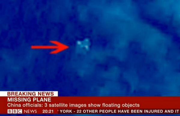
The chinese found something with a satellite

BijgjXvCEAEfzRs.png


Hard to say what it is other than it looks like the basic fuselage of an airplane sans tail. I've seen better pictures of sasquatch though.
 
Someone clarify this for me. Since the Chinese news agency supposedly had this image the day after the crash, would that not be plenty of time to search the area? Especially considering they had the exact coordinates. Something is definitely fishy about how this whole thing is unfolding.
 
from cbs news:

the images captured March 9, the day after the Boeing 777 vanished, appear to show three fairly large floating objects. The largest one is estimated to be 79 feet long and 72 feet wide.​

The horizontal stabilizer for a 777 is 70 feet wide.

exterior200_300lr.gif
 
from cbs news:
the images captured March 9, the day after the Boeing 777 vanished, appear to show three fairly large floating objects. The largest one is estimated to be 79 feet long and 72 feet wide.
The horizontal stabilizer for a 777 is 70 feet wide.

exterior200_300lr.gif

It would be nice for the families for closure if this pans out... But.... CBS news cannot get an accurate size since I am sure the Chinese does not disclose satellite image scale to protect their spy sat resolutions... IMHO.
 
It would be nice for the families for closure if this pans out... But.... CBS news cannot get an accurate size since I am sure the Chinese does not disclose satellite image scale to protect their spy sat resolutions... IMHO.

Just ask the guys flying our satellites. Pretty sure they are made in China also. ;)
 
Someone clarify this for me. Since the Chinese news agency supposedly had this image the day after the crash, would that not be plenty of time to search the area? Especially considering they had the exact coordinates. Something is definitely fishy about how this whole thing is unfolding.
Here is the interesting thing...

After the first day or so of searching the area where it originally went missing, the Chinese started getting antsy with everybody showing up to search that body of water. Then on Monday, the Malaysian military releases info (very detailed info BTW) that they tracked the aircraft turning around and heading west into the Strait of Malacca and a new search area is established.

Then a day or two later, the Malaysians reverse course and claim they never made such a statement and now the Chinese suddenly release imagery of possible wreckage spotted as a former NTSB Director said 'right where it should be' in the same body of water that they were originally searching.

The cynic in me wonders what the Chinese had to hide in that body of water.

I predict that regardless of what the investigation determines for the cause, based on the poor information flow alone, the conspiracy theories will dog this accident far worse than TWA 800.
 
Did Baghdad Bob get hired on as the Malaysian military's public relations minister?
 
I agree about the TWA800 reference.

This definitely doesn't sit right.

The one thing that comes to mind is that airplane that crashed into a South American mountain and was covered by a glacier and not found for decades. There are many glaciers within reach of the 777 under that fuel load in that area of the world.

http://en.wikipedia.org/wiki/1947_BSAA_Avro_Lancastrian_Star_Dust_accident

However a 777 is much bigger than a Lancastrian.
 
The photo was taken the day after the crash. But is it possible that there were so many images to go through that they only today found this interesting bit?
 
No offense was meant, as I said it was a joke (I was poking fun at the CAP) but I do not appreciate threats.
 
The Rolls Royce engines are now being said to transmit telemetry during the flight, and this persisted for five hours total in this flight.

Excerpts from WSJ:

Aviation investigators and national security officials believe the plane flew for a total of five hours based on data automatically downloaded and sent to the ground from the ... 777's engines as part of a routine maintenance and monitoring program ....

...
The engines' onboard monitoring system is provided by their manufacturer, Rolls-Royce PLC, and it periodically sends bursts of data about engine health, operations and aircraft movements to facilities on the ground.


Rolls-Royce couldn't immediately be reached for comment.
As part of its maintenance agreements, Malaysia Airlines transmits its engine data live to Rolls-Royce for analysis. The system compiles data from inside the 777's two Trent 800 engines and transmits snapshots of performance, as well as the altitude and speed of the jet.


Those snippets are compiled and transmitted in 30-minute increments, said one person familiar with the system. According to Rolls-Royce's website, the data is processed automatically "so that subtle changes in condition from one flight to another can be detected."
 
So it could have flown for another four hours -- somewhere around 2200 NM I'd guess.

So I drew a 2200 NM circle around the last known position, 7 degrees N, 103.5 degrees E. That circle is huge! There is no way anybody could search it. It includes all of SE Asia, Phillipines, Indonesia, Western Australia, and almost all of China and India. Not to mention what looks like half of the Indian Ocean and a huge chunk of the Pacific.

If that plane flew for another four hours, unless there's a good idea of the where it went, I think there's no point in searching any longer because there's way too much area to search.
 
Rolls Royce website explanation of the system:

Engine Health Management

Rolls Royce uses Engine Health Management (EHM) to track the health of thousands of engines operating worldwide, using onboard sensors and live satellite feeds....


Most modern large civil aircraft use an Aircraft Condition Monitoring System (ACMS) to acquire the data for EHM. This captures three types of reports:

The first are snapshots, where the sensor data listed above is captured and collected into a small report. This is carried out during take-off, during climb and once the aircraft is in cruise.

The second type is triggered by unusual engine conditions. Examples might be if an engine exceeded its TGT (Turbine Gas Temperature) limits during a take-off. These reports contain a short time-history of key parameters to enable rapid and effective trouble-shooting of the problem.

The final type is a summary, which is produced at the end of the flight. This captures information such as maximum conditions experienced during the flight, and power reductions selected during take-off and climb.
The Trent 900 is the first engine to be fitted with a dedicated Engine Monitoring Unit as well as the ACMS. ...


A critical aspect of the EHM system is the transfer of data from aircraft to ground. Aircraft Communications Addressing and Reporting System (ACARS) digital data-link systems are used as the primary method of communication. This transmits the Aircraft Condition Monitoring System (ACMS ) reports via a VHF radio or satellite link whilst the aircraft is in-flight.

A worldwide ground network then transfers this data to the intended destination. The positive aspect of this system is its robust nature and ability to distribute information worldwide. On the other hand, the Airplane Condition Monitoring Function (ACMF) reports are limited to 3kB, hence the acquisition systems need to work within this limitation. Future systems are being deployed to increase data volumes through wireless data transmission as the aircraft approaches the gate after landing. This will enable more data to be analysed, but will not be as immediate as ACARS, where data can be assessed well before the aircraft lands again.
 
Last edited:
Hmmm, if it really did fly for 5 more hours... Terrorists seem to crave publicity, and I'm not hearing much. Could have been a hijacking gone wrong.
 
Hmmm, if it really did fly for 5 more hours... Terrorists seem to crave publicity, and I'm not hearing much. Could have been a hijacking gone wrong.

They would have claimed responsibility by now...... unless they intend to use the jet as a weapon in an attack.

Just plain weird.
 
Back
Top