Literals in a sectional

t3chiman

Pre-Flight
Joined
May 18, 2017
Messages
80
Display Name

Display name:
t3chiman
pvb_airspace.jpg
Perusing the Chicago sectional, I ran across a surprising notation within the E-G airspace boundary transition around Platteville (PVB). Foreflight to the rescue. Switching Maps view from "Sectional" to "Aerial", and zooming in, revealed the truth: there really is a "M" constructed at ground level. No idea why, or if it's meaningful to a pilot searching for Platteville airport. But there it is.
 
They should have flipped it upside down when the mining school was shut down.
 
Many years ago I attended some classes at New Mexico State University in Las Cruces. There is a hill on the campus, and on the hill is a letter 'A'. I asked about it. A student told me, "That's for the football players. Next week they put up a 'B'."

PICT0074.jpg

(That pretty little University airport is long gone. The football stadium parking lot is on that site now.)
 
On the Phoenix Sectional, just above the information for Falcon Field (FFZ), you'll see a note: letters "PHOENIX".

Lots of other things like this that you'll notice.
 
In 1987 I was flying a rented 172 from Van Nuys to Phoenix Sky Harbor on a business trip. About 20 miles out from PHX I saw the letters "CATERPILLAR TRACTOR CO" carved into the sand below. I thought that was kinda cool, so I took a photo of it.

PICT02534.jpg

It was the Caterpillar proving grounds. For years sectional charts had labeled the area "Cat Tracks".

Airfields_AZ_Phoenix_SW_htm_m5dc00c0f.jpg

The Rest of The Story ... Around 2000 Caterpillar sold the land to developers and moved their proving ground elsewhere. A planned community called Verrado was built there. I now live near the center of the photo above.
 
or if it's meaningful to a pilot searching for Platteville airport.
It’s meaningful whether you’re looking for the Platteville airport or not…It’s a clear landmark for navigation, which is one of the intents of stuff on the sectional.
 
On Vashon island just west of Seattle, there used to be a pond in the shape of the John Deere logo. Haven't seen it for a while, but did find someone else's picture.
vashon john deere.jpg
Another neat thing I found locally, visible mostly only from highway 167: A construction company had a long berm of dirt at the south end of their property. They added a "HOLLYWOODLAND" letters on it.....

Found it online. Again, not my picture.
hollywoodland.jpg
It was even visible on Google Earth, about 13 years ago. You can see the shadow of the letters above the mound toward the bottom of the image... to the right of the sand traps.
google earth hollywoodland.JPG
Ron Wanttaja
 
I thought that was kinda cool, so I took a photo of it.
Off topic: I am amazed and impressed with the number of cool photos that @Pilawt has from the pre-digicam era. Grateful too, since having film developed during those days must have been not insignificant.
 
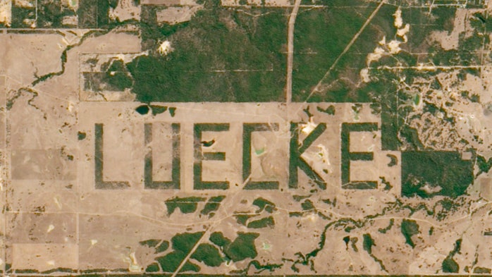
In the NJ Pine Barrens there are a bunch of fields carved into the pines in the shape of letters. I used to land my T-Craft on them (illegally as I later learned but I never got in trouble).

upload_2022-1-21_18-17-32.png
 
The Rest of The Story ... Around 2000 Caterpillar sold the land to developers and moved their proving ground elsewhere. A planned community called Verrado was built there. I now live near the center of the photo above.
You forgot to mention that the exit for Verrado was, until very recently, signed for Airport Road. I think they finally renamed the part south of I-10 Verrado Way in the past couple of years, since nobody but aviation nerds knew about the Luke auxiliary field just south of I-10. The triangle pattern is still visible from Google Earth, but not at all on the ground as far as I could tell. Buckeye Municipal also must have been a Luke auxiliary field, as the triangle pattern is visible on Google Earth, now as a backdrop to the modern asphalt runway.

Of course, Verrado has other reasons for being a great community for aviation enthusiasts. The regular free F-16 and F-35 flybys are my favorite. :)
 
nobody but aviation nerds knew about the Luke auxiliary field just south of I-10. The triangle pattern is still visible from Google Earth, but not at all on the ground as far as I could tell.
"Luke Aux 6" is still a reporting point used by the GYR controllers.

Of course, Verrado has other reasons for being a great community for aviation enthusiasts. The regular free F-16 and F-35 flybys are my favorite. :)
Indeed! My son is a USAFR Chaplain-Major at Luke.

We started an aviation club in Victory, the 55+ section of Verrado. We call it "Wings of Victory". :D At first I thought we'd just have some bugsmasher pilots getting together, but it turned out quite differently, GA is definitely in the minority. Most are Part 121 guys, retired fighter jocks, a C-130 firefighting pilot, and a retired Marine helo pilot who flew Marine One for Reagan and Bush 41. Fascinating collection, and great stories at every meeting.

BCA31417-B132-44EB-8B24-FC4FC6C8AFF6.jpeg
 
This is in Lynchburg....

It is HUGE.

Screenshot_20220121-220824_Maps.jpg
 
Last edited:
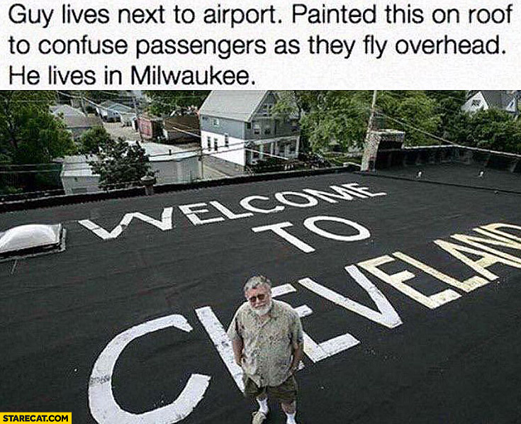
welcome-to-cleveland-written-on-a-roof-guy-lives-next-to-airport-painted-roof-to-confuse-passengers-as-they-fly-overhead-he-lives-in-milwaukee.jpg
 
It's not on the sectional, but my daughter lived for years under the big A at Colorado State University.
 
That's distinctive -- the letter M is a VFR waypoint and a VFR checkpoint as well.

Not sure why, but the sectionals that I'm finding online are somehow missing the name and symbol of that co-located waypoint and checkpoint

Screen Shot 2022-01-23 at 12.12.04 PM.png
 
That's distinctive -- the letter M is a VFR waypoint and a VFR checkpoint as well.

Not sure why, but the sectionals that I'm finding online are somehow missing the name and symbol of that co-located waypoint and checkpoint...
I pulled the image from last year's Great Falls digital sectional edition 7-Oct-2021 through 2-Dec-2021.
Just downloaded the 27-Jan-2022 edition and the VFR checkpoint is there, but the notation is gone. Bummer. I always thought VFR checkpoints had names. Otherwise how are you to report position to ATC? It shows a name on VFR checkpoints on the chart legend under Miscellaneous.
 
Back
Top