
Skybound-mg
Pre-Flight
- Joined
- Aug 17, 2021
- Messages
- 36
- Display Name
- Skybound-mg
I got a very interesting CheckRide scenario I'd love some feedback on:
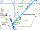
KHFD to B21 (Approach plate is attached). Route: KHFD DVANY T315 KEYNN T295 CON T395 JOBBY B21
I'm sure this airport was picked for a bunch of tricky stuff:
4. Anything else here? This is just.. a really weird airport.
KHFD to B21 (Approach plate is attached). Route: KHFD DVANY T315 KEYNN T295 CON T395 JOBBY B21
I'm sure this airport was picked for a bunch of tricky stuff:
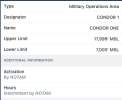
- Best criusing altitude for route is 7000' AGL AND Airport is under MOA that starts at 7000ft AGL,
- Airport only has AWOS-AV (altimiter and vis only) -- but it seems to be enhanced -- as there's METARs in Foreflight with Wind, Vis, temp, DP, Altimiter, and Density Altitude -- but no ceilings.. even Foreflight says Flight Category Unknown.
- Airport only has RNAV-GPS A (circling) -- has the inverted [C] (expanded circling minimums). (does alternate need to be other than GPS -- I have WASS, so no)
- Very confusing Procedure NA note. Look up RNAV GPS-A (B21) - Augusta VOR/DME is to the south west of the airport. "Procedure NA for arrivals at AUG VOR/DME on V39 Southwest bound" If I arrive at the VOR 38.8NM SW of the airport from southwest bound I can't do the rnav but i can if I get to the VOR/DME some other way? WHY Is this here? The turn is too tight with terrain or something?
- Hold is 5NM instead of normal 4NM for GPS,
- The airport is 880MSL, and the circling mins are 3000MSL!?
- if conditions are 1200-3 or less, min climb of (530ft/nm X 69.52 kts(80mph))/60 = 667ft/min climb. 3 adults in a 172M with full fuel, best rate of cliimb as 645ft/min at Std Temp sea level at Max Gross Weight, 882 airport elev, warm day, no go.
- lost comms -- lets say clearance limit is B21, what would I do? I'm cruising at 7000 where the MOA starts (MOA is 7000ft agl to 18000ft agl). I'm assuming I'm continuing to airport at 7000, then to fix where approach starts, if I'm early, hold at the IAFleave at a time where I will arrive at airport closest to ETA as possible -- don't deviate lower to oroca, etc as i have no clearance to do so-- no losing altitude until I am established on the approach? (lose altitude in the hold at IAF?)
- Do i need an alternate? I can't get ceilings here from the AWOS-AV- and the closest airport ALSO has AWOS-AV only. I can use approved weather sources like GFA, 1800wxbrief, etc.-- if it's severe clear I'm good, or if forecasts are clearly good I don't need an alternate.. I'd file one anyways, but this DPE will want a definitive answer: do I legally NEED one. -- if approved weather products show that forecasts for that area are good 1 hour before and after with at least 2000 ceiling and 3sm VIS I do not need one LEGALLY, but I'm damn sure filing one. Correct?
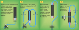
- The circling is bananas. Circling mins are 2120 feet above the airport, with the MAP at the runway. What do I do if I break out mins right near the airport at 2120 ft above? Fly a pattern twice to lose the altitude? Use one of these (like (b)) ??
4. Anything else here? This is just.. a really weird airport.


