
ILS mins higher than Loc or circ?

DaveInPA

Pre-Flight
Joined
Sep 21, 2019
Messages
60
Display Name
Dave
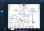
This may just be academic but it’s bugging me. This ILS approach at Rutland (KRUT) shows slightly higher altitude minimums and a lot more viz requirements for the ILS vs LOC and even circling approaches. I checked the RNAV approach plate and similar thing where LPV has higher mins than LNAV. I’ve flown it many times and there are some mountains around but it’s basically straight in through a wide valley.


What is the reason behind this?
IMG_0923.png
 
Last edited:
The rules for the obstacles differ between the ILS and the non-precision minimal. You cut off the plan view which likely shows something close into the runway.
 
The rules for the obstacles differ between the ILS and the non-precision minimal. You cut off the plan view which likely shows something close into the runway.
Updated picture and you are right there are 2 obstacles coming in on final. I guess non precision you should never go below the depicted heights on plan while precision you could go above or below the glide slope. So tighter requirements requires for precision. Makes sense now I think about it but it’s kinda non intuitive…
 
Keeps the missed approach climb gradient standard, maybe?
Usually there would be two sets of ILS minimums in that case, one standard and one with a * and a note that says something to the effect of "with minimum climb gradient of 345 ft/nm". I think that's more often used for terrain than obstacles though, so maybe not.

Paging @RussR... And is @aterpster still around?
 
Keeps the missed approach climb gradient standard, maybe?
With a difference of only 2ft, but a large variance in visibility required. I would venture the Flight Check and math calculated on the ILS the exact altitude at the Missed Approach Point. The Localizer only approach is not that accurate.

To see a wide variation in different MDA for the same approach, look at the RNAV (GPS) Rwy2 at Mesquite NV, 67L. LP approach, normal MDA is 3080 (1144 agl), the LP* MDA is 2340 (404) Min weather requirements of 1200 - 1 1/2 or 400-1. LNAV 3140 (1162) and LNAV* 2340 (404). You will also note in the Missed Approach description at the top of the chart, the * requires a minimum climb gradient of 258 feet per NM to 6200 ft. The MAP is 0.3nm before the runway threshold.

Once you fly the approach in good weather to the 2% upslope runway and see the bluff rising above the runway at the far end, you'll understand why. If you can't climb at 258feet/nm. Pick the higher minimums.
Keep in mind, too, that the ILS allows penetration below the DA while initiating the missed, so the actual point from which they calculate the gradient is going to be lower and closer to the runway. How much, I have no idea.
 
The difference in the ILS vs LOC minimums for this approach all comes down to the missed approach. When the RUT VORTAC was changed to just a TACAN several years ago, the missed approach had to be changed. The new missed approach design picks up more terrain. Due to the missed approach criteria differences between a LOC and an ILS (due to the different way they are initiated), sometimes the ILS needs a larger missed approach adjustment to the DA than the LOC needs to the MDA. This type of situation, while not very common, occurs most often with turning missed approaches like this one.
 
Just another thing to note - at least some of those RNAV and circling approaches are NA at that airport at night. I'm sure there's a reason for that, and it might be related to mountains being unlighted obstacles. Kinda common around here, and I'm sure other places, too.
 
... and a lot more viz requirements for the ILS vs LOC ...
One thing to point out is the VDP (Visual Descent Point). It's three miles from the threshold. That should roughly be where the glide slope intersects decision altitude, meaning that a decision to land on the ILS requires at least three miles visibility - otherwise you wouldn't be able to see any of the items listed in § 91.175 (c) 3.

If the visibility was really just 3/4 SM, you could fly your Category A aircraft at MDA (2160' MSL, or 1400' above airport) to the Missed Approach Point. If you spot the runway at the last minute, will you be able to meet § 91.175 (1)? Probably not.

Now, why is the required visibility for the straight-in ILS 5 miles and not 3? I do not know.

- Martin
 
Providing some more answers now that I'm at a real keyboard...

I think that's more often used for terrain than obstacles though, so maybe not.
terrain = obstacles = terrain. There is no difference in TERPS. Now, terrain will have an additive on it, either "trees" when within (usually) 20,000 feet of a runway end, or an assumed 200 ft antenna tower everywhere, which then become "obstacles". But it's all treated the same.
 
Just another thing to note - at least some of those RNAV and circling approaches are NA at that airport at night. I'm sure there's a reason for that, and it might be related to mountains being unlighted obstacles. Kinda common around here, and I'm sure other places, too.

The "Procedure NA at night" isn't placed there due to mountainous terrain. Because if you follow the procedure, the mountains, like any other obstacles, will be avoided whether it's day or night. So there's no consideration for that.

Where day vs night matters, however, is in the visual segment, below the DA/MDA, when you are expected to see obstacles and avoid them if necessary. There is what's called a 20:1 surface for each runway, and if obstacles penetrate that surface, they must be lit or the procedure is NA at night (because you can't see them). However, most typically these penetrating obstacles are trees, which usually do not have lights on them (though I have seen some that do). So, "NA at night" to a runway that is otherwise lit (i.e. runway lights) is probably 90 or 95% due to trees.

This is the case for RUT runways 13 and 31, both have unlit trees penetrating the 20:1 surface (and runway 13 has a road, which while you might think that cars driving by would count as "lit obstacles", come on you know drivers can't be counted on!)
 
One thing to point out is the VDP (Visual Descent Point). It's three miles from the threshold. That should roughly be where the glide slope intersects decision altitude, meaning that a decision to land on the ILS requires at least three miles visibility - otherwise you wouldn't be able to see any of the items listed in § 91.175 (c) 3.

If the visibility was really just 3/4 SM, you could fly your Category A aircraft at MDA (2160' MSL, or 1400' above airport) to the Missed Approach Point. If you spot the runway at the last minute, will you be able to meet § 91.175 (1)? Probably not.

Now, why is the required visibility for the straight-in ILS 5 miles and not 3? I do not know.

- Martin

The VDP is placed where the VGSI (PAPI/VASI) light angle intercepts the MDA (not the DA). The VDP isn't applicable to vertically-guided procedures since you don't need it (as the DA is always on glidepath by definition).

When I do the math using the actual TERPS formulas, though, I get that the VDP should be at 3.88 nm from the threshold, not 3.0 nm. (Note that the VGSI angle is 3.20 degrees.) This seems to be an error and I will bring it up.

The visibility for the ILS given that the threshold-to-DA distance is also about 3.88 nm (same math as the VDP) is correct. 3.88 nm = 4.46 sm. Rounded up to the next reportable visibility value is 5 sm.
 
With a difference of only 2ft, but a large variance in visibility required. I would venture the Flight Check and math calculated on the ILS the exact altitude at the Missed Approach Point. The Localizer only approach is not that accurate.

Visibility for an ILS is calculated based on the distance you are from the runway at the DA point on glideslope/path. Converted to SM. That's pretty much it. See my previous post for the math on this approach.

For any non-vertically guided approach procedure (LOC, etc.), FOR CATS C and D this is also true. Same table, same formula.

But for Cats A and B non-vertically-guided approach, there is a different table, and it tops out at 1 1/4 sm for Cat A and 1 1/2 sm for Cat B, with a reduction if there are approach lights. This is (I believe) a nod to the fact that Cat A and B aircraft can safely descend steeper than 3 degrees, and definitely gives those airplanes a little more leeway (or rope to hang ourselves with depending on your viewpoint).
 
The VDP is placed where the VGSI (PAPI/VASI) light angle intercepts the MDA (not the DA). The VDP isn't applicable to vertically-guided procedures since you don't need it (as the DA is always on glidepath by definition).

The visibility for the ILS given that the threshold-to-DA distance is also about 3.88 nm (same math as the VDP) is correct. 3.88 nm = 4.46 sm. Rounded up to the next reportable visibility value is 5 sm.
Thank you, Russ. That explains the 5 sm visibility requirement perfectly.

I understand the VDP doesn’t apply when vertical guidance is used, but it helps understand the substantial visibility required for the ILS.

Best regards,
Martin
 
The VDP is placed where the VGSI (PAPI/VASI) light angle intercepts the MDA (not the DA). The VDP isn't applicable to vertically-guided procedures since you don't need it (as the DA is always on glidepath by definition).

When I do the math using the actual TERPS formulas, though, I get that the VDP should be at 3.88 nm from the threshold, not 3.0 nm. (Note that the VGSI angle is 3.20 degrees.) This seems to be an error and I will bring it up.

The visibility for the ILS given that the threshold-to-DA distance is also about 3.88 nm (same math as the VDP) is correct. 3.88 nm = 4.46 sm. Rounded up to the next reportable visibility value is 5 sm.

FDC 5/2044 RUT IAP RUTLAND/SOUTHERN VERMONT RGNL, RUTLAND, VT. ILS Y OR LOC Y RWY 19, AMDT 1A... CHANGE VDP FROM 3.9 DME TO 4.8 DME. 2503121435-2703121435EST
 
FDC 5/2044 RUT IAP RUTLAND/SOUTHERN VERMONT RGNL, RUTLAND, VT. ILS Y OR LOC Y RWY 19, AMDT 1A... CHANGE VDP FROM 3.9 DME TO 4.8 DME. 2503121435-2703121435EST
Good deal - thank you for reporting this, Russ!
Now let's see how long it'll take for the chart update... :p

- Martin
 
Just another thing to note - at least some of those RNAV and circling approaches are NA at that airport at night. I'm sure there's a reason for that, and it might be related to mountains being unlighted obstacles. Kinda common around here, and I'm sure other places, too.

Just another data point, the approach can be NA at night because the runway lights haven't been flight checked. This was a new one to us. We recently gained a new GPS/RNAV approach to our airport after many years of request. The FAA developed, flight checked, and published our new approach, then turned around and NA'ed the approach at night because they discovered our runway edge lights had never been officially flight checked and commissioned. The other existing approaches were not affected as they are grandfathered of this requirement.

Here's the big catch, the airport sponsor has to fund the new flight check itself, since the runway lights are our property. $7,500 estimate from Flight Check to fly a King Air here and fly down the runways with the lights on, which must be pre-paid through a process known as a Reimbursable Agreement. We are working to get that done, but as with anything Federal related, it is not a simple process.
 
Back
Top