Hurricane Ida

FastEddieB

Touchdown! Greaser!
Joined
Oct 14, 2013
Messages
11,420
Location
Lenoir City, TN/Mineral Bluff, GA
Display Name

Display name:
Fast Eddie B
Right now, she seems to be aiming for the Louisiana coast, forecast to become a major hurricane before getting there. Seems like preparing an evacuation plan now might be in order.

If anyone needs a port in a storm, so to speak, we could put up a few folks at either our N GA (near Blue Ridge) or our E TN Lenoir City home. Copperhill, TN (1A3) just a few miles from the N GA home, either Knoxville or Monroe County (KMNV) for the Lenoir City home. Or just fly into our grass strip if you’re comfortable with 1,700’ of grass. Transportation available at either.

Or make this a thread about other options. Just don’t wait too long!
 
I’m wondering some about the volunteer options may exist post storm. Obviously what I did for the past 13 years of disaster relief is no longer something I can do, but I have other useful vehicles. After Katrina I went down with my motorcycle gang (Christian Motorcyclist Association) and we rebuilt a house.
 
I’ll bet there won’t be any shortage of volunteer opportunities, as this storm is really shaping up to be pretty ugly. :(
 
I’m wondering some about the volunteer options may exist post storm. Obviously what I did for the past 13 years of disaster relief is no longer something I can do, but I have other useful vehicles. After Katrina I went down with my motorcycle gang (Christian Motorcyclist Association) and we rebuilt a house.
Check out Operation Airdrop.

https://www.operation-airdrop.com/
 
You realize I don’t fly anymore and don’t have an airplane, right? :)

More thinking ground based, especially if they benefit from some of my other big equipment like truck/bus and trailers.
They are coordinating with the Cajun Navy Ground Force.
 
I heard two things on the news I can’t understand.

The first was a weather person saying that a Cat 5 was 128 times more powerful than a Cat 1. Al Roker about an hour ago said 300 times more powerful.

My understanding was that energy increased as the square of the increase in velocity. So an increase from 75mph to 150mph, a doubling, should result in a quadrupling of the force of the wind.

Am I off? And what might the weather people have been referring to?

Well, you are mixing terms between energy and power, but I don’t think that explains what the wx people said. I have no idea what they might have meant, and they probably didn’t know what they were saying, either.

“Power” is energy divided by a time interval, so “more powerful” would imply the energy is released over a shorter period of time.

But I suspect they’re clueless and are using the word “powerful” quite loosely.
 
They’re all over the map. This article says cat 5 is 500 times as powerful as cat 1 but generates 144 times the amount of “destruction”. Not sure what they mean by that. As measured by damage cost?
https://science.howstuffworks.com/nature/natural-disasters/define-hurricane-categories.htm

Hurricanes pack a lot of kinetic energy, and as a byproduct, a hurricane's power increases exponentially from one category to the next as wind speed increases. A Category 5 hurricane, for example, is 500 times more powerful than a Category 1. How does this relate to property damage? Compared to a Category 1, a Category 2 hurricane can generate seven times the amount of damage, while a Category 5 storm can generate 144 times the amount of destruction.
 
Increased storm surge maybe?
 
I heard two things on the news I can’t understand.

The first was a weather person saying that a Cat 5 was 128 times more powerful than a Cat 1. Al Roker about an hour ago said 300 times more powerful.

My understanding was that energy increased as the square of the increase in velocity. So an increase from 75mph to 150mph, a doubling, should result in a quadrupling of the force of the wind.

Am I off? And what might the weather people have been referring to?


I think it depends who is scrounging for more ratings.
 
The overall "power" of a hurricane will depend on many factors, chief among them: 1) Sustained and peak wind gusts; 2) radius of the wind fields; 3) storm surge; and 4) The velocity of the "eye" (which impacts rainfall totals).

The amount of destruction is mostly related to what and where it hits.

I rarely watch the news anymore. Haven't for many years. Just idiots blabbering to fill air time. Big storm coming? GTFO out of the way. Really all you need to know.
 
Something I've always wondered about strong hurricanes - how come there is almost never a record of winds to the speeds they say the storm is? I know a lot of stations get knocked out, but I've seen storms where a station kept broadcasting METARS and with the eye passing right over the site, the station never recorded hurricane force winds or a barometric pressure as low as the NHC said the storm had. If the site is situated poorly, then what good is it for the airport it serves?
 
And just an example - the eye is about 15 miles from New Orleans Intl (KMSY). The METAR is about 10 minutes old showing winds 49G72, but the official winds are in the 115 range. Do the wind really fall off that quickly?
 
Do the wind really fall off that quickly?
FYI: Its not a point of the wind "falling off" as it is wind is not linear. The reading you get is simply the speed at that specific sensor location. There could very well have been a gust over 100 mph at a point 100 feet from that sensor. There is also a vertical component to the reading and it depends which standard your weather sensors are set to that can affect speed comparisons as well as their location.
 
Ok, another wind speed question:
Are the reported winds from a hurricane at ground (or sea) level, or are they the maximum winds at whatever altitude that occurs? If the winds are from ground level, then how does a hurricane hunter airplane measure that?
 
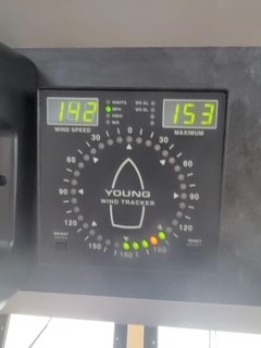
David Bernard@DavidBernardTV·
2h
Happening now ground zero Port Fourchon from Captain Scott Timmons. #idahurricane @FOX8NOLA


E9-RgzmXoAMrecF.jpg
 
Are the reported winds from a hurricane at ground (or sea) level, or are they the maximum winds at whatever altitude that occurs?
Too many variables for a single answer. A lot depends on the who what, where, why on the data. But for a reference, NOAA uses a 10 meter sensor height for most of their official wind speeds.
If the winds are from ground level, then how does a hurricane hunter airplane measure that?
The hunters drop hundreds of dropsondes that sample many parameters as they parachute down to include wind speed. Regardless there are also various mathmatical conversions for determining wind speed at different altitudes.
 
I would also add those reported winds from NHC are over open water with no obstructions. Once the wind starts passing over land, trees, buildings, etc., it diminishes a lot.
 
Maybe this time, it won’t be as bad as Harvey, which per the Seattle Times, deleted Mississippi

63B24D7C-FED7-488D-A810-52F1E0987661.jpeg
 
Maybe this time, it won’t be as bad as Harvey, which per the Seattle Times, deleted Mississippi

View attachment 99588

Being born and raised in MS, that happens a lot. There is even a Facebook group for the people in The Landmass between New Orleans and Alabama, as the Weather Channel once coined it. It's like the media is afraid of mispronouncing or misspelling Mississippi.
 
The first was a weather person saying that a Cat 5 was 128 times more powerful than a Cat 1. Al Roker about an hour ago said 300 times more powerful.

My understanding was that energy increased as the square of the increase in velocity. So an increase from 75mph to 150mph, a doubling, should result in a quadrupling of the force of the wind.

I'm not saying they're right, as they're probably way wrong, being newscasters.

But I can see one way of defining things that might make this type of statement work. It just depends how loose your definitions are.

We get a lot of wind here in Oklahoma. It's not terribly uncommon for straight-line wind to exceed 50 mph. At that speed, very minimal damage generally occurs - I mean, the house creaks a bit, garbage cans get blown around, but generally not much real damage. Now, if the wind were to get to 100 mph, you can imagine that fairly significant damage would occur. So at some point the wind speed starts to exceed design limitations and strength of houses and other buildings and such. The energy behind the wind might only be 4x, but the amount of damage may be many, many times greater (from "zero" to anything is of course an infinite increase, percentage-wise).

So if you used "damage level" as your measure of "powerful", that could work.

Same thing with rain. Up to a certain amount, the drainage systems can handle it and it's no problem. Above that though, and instantly there's major damage being caused. So another "infinite" increase.

In addition, the higher Category storms are usually (always?) larger, so they hang around longer and have more time to damage things.
 
Last edited:
September 01, 2021

[CAP] Flying Hurricane Impact Assessment Missions

https://www.cap.news/la-wing-flying-hurricane-impact-assessment-missions/

Aircrews and ground teams with Civil Air Patrol’s Louisiana Wing have joined federal and Louisiana state emergency managers’ efforts to assess Hurricane Ida’s impact.

Their mission is to gather aerial and ground-level photos and data for use by the Federal Emergency Management Agency and the Louisiana Governor’s Office of Homeland Security and Emergency Preparedness (GOHSEP).

Beginning Tuesday afternoon, the wing has flown five extensive aerial sorties, photographing areas of severe wind damage and flooding in the Greater New Orleans Metropolitan Area and in areas extending from Thibodaux south to Houma and southeast to Galliano. The flights were launched from bases in Patterson, Gonzales and Baton Rouge.

“Our thoughts and prayers are with the people of Louisiana as they continue to endure the effects of the hurricane,” said Brig. Gen. William Betts, vice commander,1st Air Force, Air Forces Northern. “CAP is working nonstop with local authorities to help the community recover as soon as possible.”

Acting as a Total Force partner and as the U.S. Air Force auxiliary, Civil Air Patrol helps 1st Air Force rapidly respond to nonmilitary threats domestically in a Defense Support of Civil Authorities capacity to save lives, relieve suffering, prevent property damage and provide humanitarian assistance.

The Louisiana Wing operates nine single-engine aircraft, some equipped with special camera and navigation systems for generating precise, high-definition photos. When called into service, these aircraft are flown by a crew of three — a pilot, an observer and a scanner/photographer.

The collected imagery and its imbedded data are immediately processed and converted into both 2D and 3D images for FEMA and GOHSEP emergency managers to use in planning and expediting recovery efforts.

CAP aircraft are also being used to maintain communications networks in Louisiana as well as in surrounding states after the storm.

"This wing has a long and distinguished history of responding to requests for assistance following disastrous hurricanes like Ida,” said.Maj. Tracy Breithaupt, commander for the damage assessment mission. “We’ll once again apply our unique capabilities in support of post-Ida recovery efforts.”

The flights are expected to continue today and through the weekend and possibly into next week.​
 
Back
Top