How thick is your average cloud layer?

drotto

Cleared for Takeoff
Joined
Dec 16, 2013
Messages
1,162
Location
NJ
Display Name

Display name:
drotto
So, I am nearing the end of my IFR training, but have only managed like 0.4 hrs of actual.That means I have not had the chance to penetrate many cloud layers. Taking CB's out of the equation, how thick is your average cloud layer? On real IFR flights, are you able to get through to the tops in many situations?
 
Depends. Could be one layer or multiple. Could be 500 feet could be 30,000 feet. Often times the tops in my area are up around 16k on a cloudy summer day.

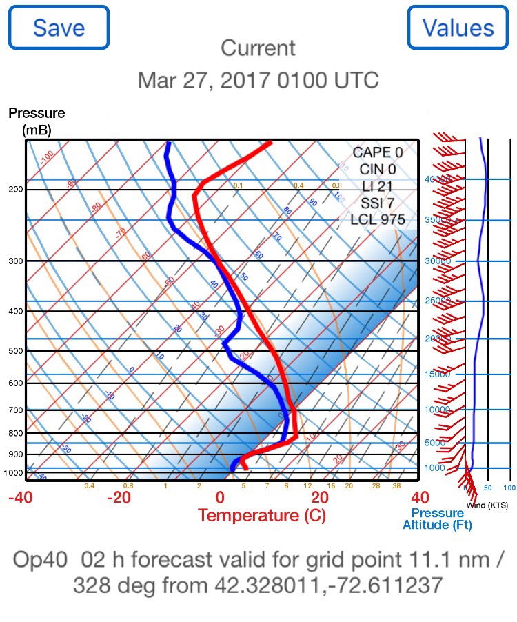
Learn about skewT charts!

Yes there is an app for that...

6e002dc3355d0afee254f2800e49c57f.jpg


Sent from my iPhone using Tapatalk
 
Depends. Could be one layer or multiple. Could be 500 feet could be 30,000 feet. Often times the tops in my area are up around 16k on a cloudy summer day.

Learn about skewT charts!

Yes there is an app for that...

6e002dc3355d0afee254f2800e49c57f.jpg


Sent from my iPhone using Tapatalk
Is that the app that's $14.99 in the App Store? That's the only one like that I could find. Looks handy.
 
I watched a few videos on skewT charts a few weeks back. Need to look again.
 
What is the airspeed velocity of an unladen swallow?
 
I've read and studied, but never got the gist of it.
Need a simplified approach for my brain.
 
I need to learn about skew-t's and that app looks handy, but I can't justify $15 for it.
 
If you don't want app, use the government webpage on your phone...


Sent from my iPhone using Tapatalk
 
Also the ADDS flight path tool is amazing. Shows you where the 100% relative humidity is across your route of flight based on the government atmospheric computer model they use for forecasting....


Sent from my iPhone using Tapatalk
 
So, I am nearing the end of my IFR training, but have only managed like 0.4 hrs of actual.That means I have not had the chance to penetrate many cloud layers. Taking CB's out of the equation, how thick is your average cloud layer? On real IFR flights, are you able to get through to the tops in many situations?

mean-formula.png

where x is cloud thickness, and N is the number of cloud samples.
 
The basic thing you need to know is 100pct humidity or close = cloud. 100pct humidity is where the two plots come together. Aka dew point gets to the temperature. Where there is a gap, that's where clouds generally end...


Sent from my iPhone using Tapatalk
 
The basic thing you need to know is 100pct humidity or close = cloud. 100pct humidity is where the two plots come together. Aka dew point gets to the temperature. Where there is a gap, that's where clouds generally end...


Sent from my iPhone using Tapatalk
So on that first graph that was shown, where the two lines come together is a cloud layer. Then you get a clear layer, and where they come together again higher up you get a second layer?

Sent from my SM-G920V using Tapatalk
 
Pretty much. And slope says something about air stability...


Sent from my iPhone using Tapatalk
 
Q: how thick is your average cloud layer?
A: how high can your average place every climb? Some layers will be thinner that this, some will be thicker. Don't forget to include the altitude to the base of the clouds when trying to climb over them . . . You just asked for "thickness," not altitude of the tops.
 
Taking CB's out of the equation, how thick is your average cloud layer?

I don't know if there's any average layer, but here's one example. For the approaches I did yesterday, just a few hours after a low-pressure came through and fog was lifting, there was an overcast stratus layer that turned out to be 700' thick. When I launched the base was at 700' AGL, and after I climbed above that layer I could see the tips of a pair of 1456' TV towers just poking through the top of the clouds.
 
Even non CB weather can top out above your service ceiling unless you're in a jet...


Sent from my iPhone using Tapatalk
 
Another vote for Skew-T charts.
They seems overly complicated at first but once you learn how to read them and how to extract basic information from them, you'll see they are not as bad as they seemed.
And they contain a lot of useful information.
 
Even non CB weather can top out above your service ceiling unless you're in a jet...
Sent from my iPhone using Tapatalk

Not always. Squall lines with 45,000ft tops will force airliners to divert around and not over.
 
So on that first graph that was shown, where the two lines come together is a cloud layer. Then you get a clear layer, and where they come together again higher up you get a second layer?

Sent from my SM-G920V using Tapatalk

Basically. The line on the right is the temp, on the left is the dew point. So where you see the Temp/DP plots come close together you can expect clouds. Based on the thickness of the layer you'll see the Temp/DP spread stay pretty close until they don't and that's where the clouds can be expected to clear.

Skew T's are great too for finding icing:

You have temperature graph lines that angle up and to the right. So if you see the temp and dew point close together to the left of 0 degrees Celsius then you know you're going to get some visible moisture below freezing. Unless of course the temperature spikes at 1,500 feet and moves to the right of the 0 degree celsius line. Then you can see clearly that there's an inversion aloft and to expect some freezing rain.

And they're great for finding wind shear and potential favorable winds aloft. Oh, also by looking at the CAPE value you can evaluate the potential for severe convective activity. The FAA often does Skew T seminars that are very much worth attending.
 
Not always. Squall lines with 45,000ft tops will force airliners to divert around and not over.

I said *non* CB weather can be higher than light aircraft can go. Of course CB weather can force everyone around...


Sent from my iPhone using Tapatalk
 
So, the $15 iPhone app for Skew-T charts. Is its interface good enough to justify the cost? I haven't bought it mostly because I am afraid it will not be any easier to use than the website and my money will be wasted. That's 3 gallons of 100LL, you know. Very expensive!
 
Back
Top