How many GPS Units do you fly lwith.

What about carrying back up charts that way you won't have to can a flight if one of your EFBs fail?
And don't forget an extra set of paper charts in case you lose the paper charts you carried as a bsckup for two sets of electronic charts and a panel mount GPS.

IOW, completely unnecessary.
 
I don't have a data plan for my Ipad so I use paper charts.
I don't have a data plan for either of my electronic chart tablets.

But yes, definitely. Not knowing how equipment works is the very best reason not to use them I can think of.
 
Last edited:
Watching the responses to this thread, I find myself pretty surprized by how may devices a lot of people have in the cockpit. Just out of curiosity, what is the need for up to 4 gps devices? Nothing derogatory intended, just curious.

Here's a question: At some point, does the amount of gizmos in the cockpit become a danger rather than a safety feature?

It does, but if you read through the thread you will see that the devices for most of us break down to:

1. Something panel mounted (you have at least a VOR, don't you?)
2. An EFB (you do have charts for the flight, checklists, manuals, and a AFD, don't you? Maybe not, I know lots of pilots who never carried an AFD since they were student pilots - that is, until they started using an EFB.)
3. A backup of some sort (not everyone - do you have a backup in case of that sudden rainstorm that destroys the sectional you layed out on the wing to review the course?)
4. Something that just incidentally happens to have an internal GPS (do you use a modern smartphone?)

IOW, are you really carrying around any fewer items than us?
 
When I did my helicopter add-on rating a few years ago, after having used NDB/VOR/Loran/GPS for decades of fixed-wing flying, I decided as a challenge to not use any electronic navigation means for my cross-countries.
Turned out to be an amazing experience, which added a lot to my enjoyment.
The way I did that is to carefully study Google Earth the night before each flight, memorizing the view of the terrain and landmarks from different angles, at the planned altitude. I wrote an article (never published) about it, calling my in-flight navigation tool "a super high res full color moving map, always up to date." :)
 
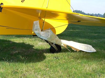
A backup of some sort (not everyone - do you have a backup in case of that sudden rainstorm that destroys the sectional you layed out on the wing to review the course?)
... Or if you fly with the window open and this happens ...

P1040895.JPG
 
When I did my helicopter add-on rating a few years ago, after having used NDB/VOR/Loran/GPS for decades of fixed-wing flying, I decided as a challenge to not use any electronic navigation means for my cross-countries.
Turned out to be an amazing experience, which added a lot to my enjoyment.
The way I did that is to carefully study Google Earth the night before each flight, memorizing the view of the terrain and landmarks from different angles, at the planned altitude. I wrote an article (never published) about it, calling my in-flight navigation tool "a super high res full color moving map, always up to date." :)

I'm actually ferrying a helo 330 miles tomorrow. Although I'll have a 430 & 530, it's non glass and the company ordered paper pubs for the flight. I don't think 135 will get around a paper back up anytime soon.

We used to memorize an entire route in the Army as well. Last ditch option if the electronics fail or somehow your maps are lost. There were short tactical routes though. Nothing like a cross country.
 
Last edited:
I'm actually ferrying a helo 330 miles tomorrow. Although I'll have a 430 & 530, it's non glass and the company ordered paper pubs for the flight. I don't think 135 will get around a paper back up anytime soon.

I should mention that although I had a paper chart for my student cross-country trips, due to both doors being removed I had to sit on it, which is not much use if both your hands and feet are busy in an R-22. :)
(I use my N7 GP tablet strapped to my knee for heli flights since I got rated.)
 
Last edited:
One 430W. I have a smartphone on my belt, I've used it on the ground to get clearance a few times, never in the air. Sometimes I think to update my tablet software, charge it up and take it with me, but more often than not I then either put it in with the baggage or forget to turn it on. When traveling, I usually have enough things to charge--my phone, my camera, her phone, her camera, at least one tablet if not two.

Who NEEDS more than one panel-mounted, approach-capable GPS? If you're depending on non-certified handhelds, then I can see your reasons for having several out and running, since you never know when one will quit, burp, hiccup or flake out.

I also have a sectional chart folded open to where I am. It lives folded open to my home field, between the front seats beside the trim wheel, and my home Approach Plate book lives on the floor beneath the throttle quadrant. What else does a man need to fly? This has worked well for me, west to Yellowstone, north to Niagara, south to Miami and up and down the East Coast (no congested New England yet).
 
Last edited:
One 430W. I have a smartphone on my belt, I've used it on the ground to get clearance a few times, never in the air. Sometimes I think to update my tablet software, charge it up and take it with me, but more often than not I then either put it in with the baggage or forget to turn it on. When traveling, I usually have enough things to charge--my phone, my camera, her phone, her camera, at least one tablet if not two.

Who NEEDS more than one panel-mounted, approach-capable GPS? If you're depending on non-certified handhelds, then I can see your reasons for having several out and running, since you never know when one will quit, burp, hiccup or flake out.

I think many of use who use tablets/ipads do that in lieu of paper charts. And if you do that, it becomes an essential piece of gear, where a backup is required.
 
Lessee, a $600 iPad to back up a $6 chart and $5 book of plates . . . Remind me again why so many people say that flying is expensive? :yes: :D

OK, a year's worth is TWO $6 charts and EIGHT $5 books, or $52.

Yes, I have an iPad mini, too, but I only fly with it as baggage. Avare is on my really old Samsung tablet, but I hardly ever fly with it, either; sometimes I'm out running errands and end up at the airport--do you really take your tablet everywhere you go?
 
Last edited:
Lessee, a $600 iPad to back up a $6 chart and $5 book of plates . . . Remind me again why so many people say that flying is expensive? :yes: :D

I don't know anyone that bought an iPad or other tablet solely or even primarily for electronic charts. You get a lot more for $600 than charts.

The fact that I can use my iPad as an EFB is just a bonus.
 
That's what I did: the iPad is just for charts. I was thinking the other day about how old my paper backup charts are getting an how much trash I would have generated if I didn't have the iPad...

I have two operational gps units: 430 and a gar in area backup.
 
Lessee, a $600 iPad to back up a $6 chart and $5 book of plates . . . Remind me again why so many people say that flying is expensive? :yes: :D

OK, a year's worth is TWO $6 charts and EIGHT $5 books, or $52.

Yes, I have an iPad mini, too, but I only fly with it as baggage. Avare is on my really old Samsung tablet, but I hardly ever fly with it, either; sometimes I'm out running errands and end up at the airport--do you really take your tablet everywhere you go?

I think it all depends on what type of flying you're doing.

Most of my flights are local. I barely use the GPS in the panel. A kneeboard device would get no use whatsoever. I can fly anywhere within around 50 miles of my airport without the GPS; pilotage.

If I flew a lot of IFR XCs then I might invest in some sort of kneeboard backup. I'm no longer current for IFR and don't plan on getting current anytime soon so no need.

For work I'm VFR and have a 430, 530 and G500Hs. A tablet sitting on my kneeboard would be a waste. If we were issued them, it would just sit on a shelf and never get used.

So, for those that do a lot of XCs I can see some benefit of having an IFR panel GPS with a tablet backup. There's no sense of living in the stone ages with paper and VOR NAV. All I'm saying is, there's no reason why a pilot can't immediately go to a paper backup and VOR, or God forbid, an NDB when tech fails...and do all that without an auto pilot.:eek:
 
Lessee, a $600 iPad to back up a $6 chart and $5 book of plates . . . Remind me again why so many people say that flying is expensive? :yes: :D

OK, a year's worth is TWO $6 charts and EIGHT $5 books, or $52.

Yes, I have an iPad mini, too, but I only fly with it as baggage. Avare is on my really old Samsung tablet, but I hardly ever fly with it, either; sometimes I'm out running errands and end up at the airport--do you really take your tablet everywhere you go?

Here is my math, feel free to find the bugs.
My paper IFR subscription (cheapest, NOS), was around $200 per year.
My Android 2013 Nexus 7: around $170 (Amazon)
My Garmin Pilot IFR subscription: $150 per year.
So far I am $120 in the red, but...
The first N7 is my primary one, which I use for navigation and lots of other stuff, and I would still need to carry a set of backup charts in case it decides to die.
So, from my perspective, it is the *second* N7 which actually (and legally) replaces the paper charts, since only by buying the second one can I toss the paper charts subscription.
And the second N7 costs (one time) $170, to replace $200 per year worth of charts. (GP subscription covers the backup unit for free.)
(I am ignoring the fact that paper sucks and GP N7 gives me tons of other stuff.)
So what am I missing?
 
Between my student and I, it normally floats around 7.

2 430s
2 phones
3 GPS receivers for iPad.

So if we ever get lost then something HORRIBLY has gone wrong. :lol:

Sometimes it can be as high as 11 if we have two aviation students as our passengers.
 
Lessee, a $600 iPad to back up a $6 chart and $5 book of plates . . . Remind me again why so many people say that flying is expensive? :yes: :D

OK, a year's worth is TWO $6 charts and EIGHT $5 books, or $52.

Yes, I have an iPad mini, too, but I only fly with it as baggage. Avare is on my really old Samsung tablet, but I hardly ever fly with it, either; sometimes I'm out running errands and end up at the airport--do you really take your tablet everywhere you go?
you're getting some amazing deals on paper charts. Back when I first paid ~$600 for an ipad1 and ~$70 for a years of foreflight, it paid for itself in the 1st year of no paper.
 
You can buy a $250 iPad mini if all you really want it for is charts. I think it's worth springing for a mini2 with at least 32gb of storage and cellular connectivity but I use mine daily for non-aviation related things so I don't weigh the cost against the cost of charts that way.

However, even without the GPS features I'd still go with the iPad both for in the air and pre-flight planning. It's just easier to use than paper sectionals and the AF/D books. I can find what I'm looking for faster and lay out routes/measure distances/etc faster. Also takes up a lot less space, don't have to deal with putting away one chart and getting out another if I cross over, etc, etc. I can see carrying paper charts for backup, I carry them they're just not current, I also see the value in teaching new students how to use the paper first, but I scratch my head as to why one would prefer it even if it did come out a few dollars cheaper.
 
Garmin 92 handheld., that and paper charts got me from Houston, TX to Dayton, Oh. Did a leg without GPS, it lost signal, but came back on, Aeronca L3 with no electrics


Sent from my iPhone using Tapatalk
 
you're getting some amazing deals on paper charts. Back when I first paid ~$600 for an ipad1 and ~$70 for a years of foreflight, it paid for itself in the 1st year of no paper.

I have a subscription with JoePilot.com, prices are unbeatable. They are delivered to me cheaper than most places sell them, before tax and shipping. About half the cost of Sportys.
 
I have a subscription with JoePilot.com, prices are unbeatable. They are delivered to me cheaper than most places sell them, before tax and shipping. About half the cost of Sportys.
I doubt they are cheaper than the howie keefe books used to be. Still was pushing $800 to cover the lower 48 VFR and IFR
 
Lessee, a $600 iPad to back up a $6 chart and $5 book of plates . . . Remind me again why so many people say that flying is expensive? :yes: :D

OK, a year's worth is TWO $6 charts and EIGHT $5 books, or $52.

Yes, I have an iPad mini, too, but I only fly with it as baggage. Avare is on my really old Samsung tablet, but I hardly ever fly with it, either; sometimes I'm out running errands and end up at the airport--do you really take your tablet everywhere you go?
Well if you don't leave your own backyard... When I had paper, I needed a lot more than that to go within 100 NM.
 
I don't know anyone that bought an iPad or other tablet solely or even primarily for electronic charts.
You do now. I did.

I found it does a lot more for me than that, but the one and only reason I bought my first gen iPad was the early ForeFlight. Even back then in the olden days, I thought it gave me so much more than paper (even without all the other stuff that replaces the desktop at the FBO!). And having watched someone fold and unfold and search and do it again just a few weeks ago, I still do.

But that doesn't mean it has to be for everyone.
 
Even back then in the olden days, I thought it gave me so much more than paper (even without all the other stuff that replaces the desktop at the FBO!).
But that's just my point. You knew at the time you were getting more than just a paper chart replacement, so trying to compare the cost of an iPad to a paper chart subscription is not a valid comparison.
 
But that's just my point. You knew at the time you were getting more than just a paper chart replacement, so trying to compare the cost of an iPad to a paper chart subscription is not a valid comparison.
I haven't been following this in detail but I did get my iPad (and convert from my Android phone) exclusively for aviation purposes, specifically for FF and my goal of a paperless cockpit. After flying single pilot IFR sans AP and with paper maps, I was determined to streamline the workload. Of course the AP was the key tool but getting rid of the paper (and the bloody updates) was a major upgrade.

To compare its cost with paper charts doesn't account for all the functionality of FF but FF is what I got my iPad for.

Up until recently my iPad Air was always with me for Web browsing and such. On my last trip I finally left it at home knowing I could use my iPad and iPhone for any non-aviation purposes.
 
But that's just my point. You knew at the time you were getting more than just a paper chart replacement, so trying to compare the cost of an iPad to a paper chart subscription is not a valid comparison.
Agreed on that point - that a cost comparison isn't really valid because an EFB app is more than just an electronic chart - which is a bit different than the post I answered.
 
Last edited:
Five.

Ipad
Android
GPS496
D2 watch
Dual

My backups have backups.
 
A lot of my local flights, the glass may not even get turned on - but...

in the 172 I've got 2, and in the RV9A I've got 5.
 
Between 0 and 3.

Depends if the aircraft is equipped, and if I feel like bringing my tablet.

A GPS is not essential flight equipment unless you are flying in IMC into an airport with only GPS approaches.
 
Between 0 and 3.

Depends if the aircraft is equipped, and if I feel like bringing my tablet.

A GPS is not essential flight equipment unless you are flying in IMC into an airport with only GPS approaches.
Agreed, although since I got an iPhone, I don't think I have ever flown with no GPS.
 
Back
Top