GPS in lieu of DME

Flying_Goat

Filing Flight Plan
Joined
Oct 8, 2025
Messages
15
Display Name
Flying_Goat
When using GPS in lieu of DME to identify a DME fix, can your position be legally determined based on graphical representation relative to the fix on the GPS? Or does your GPS have to actually indicate a distance from a DME?

In context, ILS approach where the FAF is a DME fix, but the DME is NOTAM'd out of service. Can I "identify" the fix when I see I'm crossing it on my GPS? At this point I'm on green needles and the GPS is showing distance to the runway, not necessarily the DME distance. In this case we are under radar coverage and my instructor insists we have to have our fix called by Approach since I can't accurately measure DME.

Thoughts?
 
The AIM says “Uses of Suitable RNAV Systems. Subject to the operating requirements, operators may use a suitable RNAV system in the following ways.
  1. Determine aircraft position relative to, or distance from a…DME fix;”

It doesn’t say “distance from a DME station to determine…”
 
Last edited:
When you are at the correct altitude listed and intercept the glide slope, there is your FAF.
Agreed, but let's change to a step down fix inside the FAF. It's a named fix in the approach so I know my distance to the fix and I know when I'm crossing it based on GPS, but I'm not reading a distance to a DME. Still good?

By MauleSkinner's post, which I agree with, I have "identified" the fix when I cross it per my GPS, even if I'm not reading a DME distance. Curious if there are any other thoughts out there.
 
graphical representation relative to the fix on the GPS?
If you are referring to the GPS moving map, the moving map has exactly the same legal status for navigation as an EFB on an iPad - situational awareness only.

As already mentioned, the final approach fix for an ILS is glide slope intercept at the published intercept altitude, not a DME or ADF waypoint. OTOH, if you are flying the LOC only and it’s required, GPS can be used instead of DME.

Can you point to a specific approach? It’s often more helpful to discuss something like this in the context of a real procedure than a hypothetical “what if an approach had something like…”
 
When using GPS in lieu of DME to identify a DME fix, can your position be legally determined based on graphical representation relative to the fix on the GPS? Or does your GPS have to actually indicate a distance from a DME?

In context, ILS approach where the FAF is a DME fix, but the DME is NOTAM'd out of service. Can I "identify" the fix when I see I'm crossing it on my GPS? At this point I'm on green needles and the GPS is showing distance to the runway, not necessarily the DME distance. In this case we are under radar coverage and my instructor insists we have to have our fix called by Approach since I can't accurately measure DME.

Thoughts?
Yes you can identify a published fix in the database with GPS when you cross it. Approach cannot call the Fix unless it is a Radar Fix. It will say on the Chart if it is. What Approach are you talking about? Also what Navigator are using. It will help us with giving more detailed advice to you.
 
By MauleSkinner's post, which I agree with, I have "identified" the fix when I cross it per my GPS, even if I'm not reading a DME distance. Curious if there are any other thoughts out there.
The fix is what you are trying to identify, not the DME distance. With a DME receiver, you use the DME distance to identify the fix. An approved RNAV unit identifies the fix through means other than the DME distance.

Read the AIM section on RNAV substitution and the installed GPS supplement for specifics on how to comply with the "suitable navigation" requirement with the specific unit and installation in your airplane.
 
Just to clarify with regard to your terminology…
When using GPS in lieu of DME to identify a DME fix, can your position be legally determined based on graphical representation relative to the fix on the GPS?
No. As @midlifeflyer noted, the graphical representation is for situational awareness only, and not for navigation. See GPS documentation in your AFM/POH.
Or does your GPS have to actually indicate a distance from a DME?
No, per the AIM reference, which is probably mirrored in your GPS documentation in the AFM/POH.

A legal option would be
At this point I'm on green needles and the GPS is showing distance to the runway,
with a charted distance from the runway to the fix you’re identifying.
 
Agreed, but let's change to a step down fix inside the FAF. It's a named fix in the approach so I know my distance to the fix and I know when I'm crossing it based on GPS, but I'm not reading a distance to a DME. Still good?

By MauleSkinner's post, which I agree with, I have "identified" the fix when I cross it per my GPS, even if I'm not reading a DME distance. Curious if there are any other thoughts out there.
There are other thoughts out there, but so far not here. I had a CFII giving me an IPC that had it wrong. The plane we were flying had DME and he was correct in ensuring the DME was dialed in and I wasn’t using the distance from the airport. I said yeah, I get that, but I can use GPS to identify the fix when we cross it. He didn’t agree. I tried to explain it to him but…

1775923464327.jpeg
 
Why would an instructor be trying to identify fixes after the faf on an ILS? Are you talking about the vdp? If you are on an ILS after glideslope intercept at the intercept altitude there is no point in identifying fixes for a localizer only approach, other than the vdp. Your approach plate will give distances to the fixes from the end of the runway in the profile view. So if you are doing a localizer only look at the profile view where you can get the distances from the end of the runway and use your panel mounted GPS to verify when you cross them.
 
  • Like
Reactions: WDD
1-1-19 still allows gps distance to determine waypoint at an "along track" distance, but not to provide distance from a navaid as in a DME arc. But I still don't understand (I agree with DixieBlueSky) what the CFI is trying to acomplish.

B
 
1-1-19 still allows gps distance to determine waypoint at an "along track" distance, but not to provide distance from a navaid as in a DME arc.
"Subject to the operating requirements, operators may use a suitable RNAV system in the following ways.
"1. Determine aircraft position relative to, or distance from a VOR (see NOTE 6 below), TACAN, NDB, compass locator, DME fix; or a named fix defined by a VOR radial, TACAN course, NDB bearing, or compass locator bearing intersecting a VOR or localizer course.​
***​
"4. Fly an arc based upon DME."​
- AIM 1-2-3.c.​

Yeah, I don't know either. That's why I asked what the specific approach was.
 
I'm not following. Are you saying you would want to identify the VDP on an ILS?
I am trying to figure out why an instructor wants him to identify any sort of fix on an ILS after the FAF at all, let alone thinking he needs approach to identify it for him.

If they are just flying the localizer all he needs is the localizer signal and his panel mounted GPS distance to identify the FAF. It would be very helpful to know exactly what GPS unit is being used to figure out what info is capable of being displayed.

If by GPS we are talking about an EFB then no you could not legally use that distance but still the FAF will be identifiable with altitude and glideslope for the ILS, still not needing any input from approach.

While I was typing that I was just thinking is it possible the instructor was just asking how one can identify a VDP. When you are out flying approaches in training it is common to just toss in questions related to approaches. "How can one identify the VDP for the approach we are flying"? Type of deal
 
The fix is what you are trying to identify, not the DME distance.
Thanks for putting that so succinctly. That's the core of my original question...am I identifying a fix or a distance? My thought is the same.

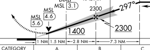
I think my original question (and interaction with my instructor) sound confusing because I was wrapping a couple discussion points from different approaches into a single scenario in my post. Maybe a better example would be KMSL LOC Z RWY 30. In this case, after FAF the DME is behind you and fixes are distance from the DME. I get that named fixes will be in the approach sequence on the navigator, but VPD and MAP are DME distance to the DME behind you. My thinking is the MAP will be identifiable as RWY30 in the approach sequence, but how would you determine VDP?

I"m on a GNC355 / G5's / VOR on COM2 / GFC 500
 
I am trying to figure out why an instructor wants him to identify any sort of fix on an ILS after the FAF at all, let alone thinking he needs approach to identify it for him.

If they are just flying the localizer all he needs is the localizer signal and his panel mounted GPS distance to identify the FAF. It would be very helpful to know exactly what GPS unit is being used to figure out what info is capable of being displayed.

If by GPS we are talking about an EFB then no you could not legally use that distance but still the FAF will be identifiable with altitude and glideslope for the ILS, still not needing any input from approach.

While I was typing that I was just thinking is it possible the instructor was just asking how one can identify a VDP. When you are out flying approaches in training it is common to just toss in questions related to approaches. "How can one identify the VDP for the approach we are flying"? Type of deal
The original post was about identifying the FAF, not fixes inside. There is a good reason to Identify the FAF if the Approach does have Localizer only minimums and the Missed Approach Point is timed. When crossing the FAF you start the timing. Then if you lose the Glideslope you can simply continue at or above the MDA and maybe be able to land. One could call that something like,,drumroll please…wait for it….:devil:alternate minimums:devil:
 
When using GPS in lieu of DME to identify a DME fix, can your position be legally determined based on graphical representation relative to the fix on the GPS? Or does your GPS have to actually indicate a distance from a DME?

In context, ILS approach where the FAF is a DME fix, but the DME is NOTAM'd out of service. Can I "identify" the fix when I see I'm crossing it on my GPS? At this point I'm on green needles and the GPS is showing distance to the runway, not necessarily the DME distance. In this case we are under radar coverage and my instructor insists we have to have our fix called by Approach since I can't accurately measure DME.

Thoughts?
Bears repeating the FAF on an ILS is never a DME fix and there is no requirement to identify the Localizer FAF it unless you're doing a Localizer-only.

The GPS will have said FAF in it, in this case (KMSL LOC Z RWY 30) TICVU. Not intimately familiar with the GNC355 but when you load an approach it should load all of the fixes in the approach. Alternately you can use 5.3nm from the runway, as shown by the distances in the profile view. Using your position in relation to fixed on the moving map is not an appropriate technique. The map is only for situational awareness.

VPD and MAP are DME distance to the DME behind you.
Every approach certified GPS will tell you when you're at the MAP. The VDP in the example is 1nm from the MAP. You don't need a read out of your position in relation to MSL DME. That's not what "GPS in lieu of DME" means. You just need to know where you are in relation to the appropriate fixes, e.g., X miles from the runway threshold. Not X miles from the DME transmitter.
 
Last edited:
Then if you lose the Glideslope you can simply continue at or above the MDA and maybe be able to land. One could call that something like,,drumroll please…wait for it….:devil:alternate minimums:devil:
One could also call it a bad idea.

I was taught the same by my CFIIs, long ago. Since then, experience has taught me that the safer strategy is to fly the approach that you set up for, and if something goes awry (i.e. the glideslope fails), fly a missed approach and sort things out with plenty of air and time between you and the unforgiving earth. By attempting to save the day by turning a precision (ILS) approach into a non-precision, especially after passing the FAP/FAF, we set potential traps for ourselves. Oh sure--it works fine during training, when we fly familiar approaches into familiar airports in (usually) decent weather and with an instructor or safety pilot. But in the real world, especially single-pilot in hard IFR, it creates additional, and entirely unnecessary, risks.

Don't create risk, minimize it.
 
Last edited:
Maybe a better example would be KMSL LOC Z RWY 30. In this case, after FAF the DME is behind you and fixes are distance from the DME. I get that named fixes will be in the approach sequence on the navigator, but VPD and MAP are DME distance to the DME behind you. My thinking is the MAP will be identifiable as RWY30 in the approach sequence, but how would you determine VDP?

I"m on a GNC355 / G5's / VOR on COM2 / GFC 500
When the display shows 1 mile from the MAP?
1775990117207.png

You are using an approach certified GPS. The concept of GPS in lieu of DME by putting MSL in the box and relying in the negligible difference between straight line and angular distance at these altitudes is mostly theoretical in that context.
 
Last edited:
The original post was about identifying the FAF, not fixes inside. There is a good reason to Identify the FAF if the Approach does have Localizer only minimums and the Missed Approach Point is timed. When crossing the FAF you start the timing. Then if you lose the Glideslope you can simply continue at or above the MDA and maybe be able to land. One could call that something like,,drumroll please…wait for it….:devil:alternate minimums:devil:
Or you could ignore the time completely and just maintain the descent rate you had on the glideslope and go missed if you don’t see anything by the time you get to MDA. :devil:
 
When the display shows 1 mile from the MAP?
View attachment 151418

You are using an approach certified GPS. The concept of GPS in lieu of DME by putting MSL in the box and relying in the negligible difference between straight line and angular distance at these altitudes is mostly theoretical in that context.
That’s a great point. I was hyper-focused on DME distance and didn’t consider distance from runway which would be sequenced (and distance shown) in the navigator.
 
I"m on a GNC355 / G5's / VOR on COM2 / GFC 500
Have you read the section of the AIM on RNAV substitution as well as the AFM supplement for your airplane's GPS installation? It should be with the AFM in the airplane. Those two references are the official sources on how to use your airplane's GPS installation for DME substitution.

This one's pretty easy, though. 1.0nm from the MAP fix. It's right there on the profile view of the plate.
This is instrument stuff. It's not allowed to be that simple :D

But I don't think the ever-changing FAA guidance on substitution is actually discussed in either the unit Pilot Guide or the AFMS.
 
Last edited:
Appreciate all the input. I’ve read all the things. I just want to think and talk through these things to square it all with real-world best practices. I think people forget that just talking about things is a form of learning and helps internalize what’s in the manuals.
 
If you are referring to the GPS moving map, the moving map has exactly the same legal status for navigation as an EFB on an iPad - situational awareness only.

In most GPS Moving Maps, they display a Navigation CDI and can display distances. There is notification in most cases passing named points or when you are navigating to the MAP, provide distance to the MAP. So one can be displaying the Navigation Map and be setup to see relevant distances. So although the graphical display of the map might not be more than providing additional situational awareness, the data and CDI on the Map view can be used IMHO to determine relevant distances.
 
In most GPS Moving Maps, they display a Navigation CDI and can display distances. There is notification in most cases passing named points or when you are navigating to the MAP, provide distance to the MAP. So one can be displaying the Navigation Map and be setup to see relevant distances. So although the graphical display of the map might not be more than providing additional situational awareness, the data and CDI on the Map view can be used IMHO to determine relevant distances.
I was referring specifically to the moving may and people who try to fly the magenta line on the Map. You know, the one that makes you look like you are spot on laterally at certain common zoom settings while you are actually at full CDI deflection (I caught a client at that recently)? The relevant distances and times to the next fix, etc. are no different than the ones in the flight plan or transferred to a PFD., just displayed in a different location.

The CDI depiction? You'll notice that most GPS navigators/FMS limitations require an external CDI for IFR flight and contain language like this one from the Garmin GTN xi AFMS:
"The moving map and CDI depiction on the GTN Xi display must not be used for primary course guidance."​
Just like the synthetic vision page in an EFB.
With the exception of DME arc, DME is not used for "primary course guidance" and even arguably is not primary for course guidance on a DME arc, so this does not apply. DME distance is not displayed on a CDI. So distance is different than CDI deflection.
 
With the exception of DME arc, DME is not used for "primary course guidance", so this does not apply. DME distance is not displayed on a CDI. So distance is different than CDI deflection.
In which case, you fly based on the distance readout as specifically permitted in AIM 1-2-3.c., not the magenta curve on the moving map. Maybe not, but I'm pretty sure that's what I said.

I guess one can view it differently, but I think of moving map, CDI, and the data fields I choose to display on FMS mages as three different things even if they are tossed onto one screen.
 
I honestly can’t think of an ILS/LOC where luck would be required.
If you did what you described if the Glideslope failed, “Or you could ignore the time completely and just maintain the descent rate you had on the glideslope and go missed if you don’t see anything by the time you get to MDA” you might need some. Changing winds could have you ‘missing’ pretty far from the Missed Approach Point. In some areas obstructions could become an issue.
 
If you did what you described if the Glideslope failed, “Or you could ignore the time completely and just maintain the descent rate you had on the glideslope and go missed if you don’t see anything by the time you get to MDA” you might need some. Changing winds could have you ‘missing’ pretty far from the Missed Approach Point. In some areas obstructions could become an issue.
How much would the winds have to change to cause problems? And how did you determine the wind gradient to properly calculate your time for the approach? And how far beyond the MAP would the localizer antenna have to be in order to not go missed because of full deflection?
 
Last edited:
My thinking is the MAP will be identifiable as RWY30 in the approach sequence, but how would you determine VDP?
Two possibilities... The Garmin devices when then generate their Advisory Vertical Guidance will put a Waypoint often at or close to the VDP. So when you first put in the approach, take a look and see if that Wpt is at the same spot or not. For the LOC Z RWY 30 it looks to be .2 off. So the next thing thing is just to do, if it will not distract you on the approach, is do the math. You can set one of the User Fields to be Distance to Destination, so as you pass DIXLI subtract 1.5nm from the distance (I'm guessing the Distance given by the GNC is going to be to the AIRPORT, not the Touchdown Zone, so that's why you need to do the math).

Also be sure to note that if you're following the GPS vs really flying the LOC, its Advisor Vertical Guidance is taking you down only to 1200ft and NOT the 920ft the minimums for the LOC. So be sure you're flying the LOC and its minimums and only use the GPS for distance. If you fly the AVG on a real minimums day you may not break out and incorrectly Go Around because of that GPS "Advisory" GP.
 
How much would the winds have to change to cause problems? And how did you determine the wind gradient to properly calculate your time for the approach? And how far beyond the MAP would the localizer antenna have to be in order to not go missed because of full deflection?
I didn’t calculate. Your example was not to do that. “Or you could ignore the time completely and just maintain the descent rate you had on the glideslope and go missed if you don’t see anything by the time you get to MDA.” Yeah, if you got as far as the LOC antenna you’d wanna miss then. On a real long runway that could put you more than a couple miles beyond the MAP. And if it was a stiff head wind you could end up pretty short of the MAP. I’d be pretty uncomfortable trying it in a slow climbing plane.
 
I didn’t calculate. Your example was not to do that. “Or you could ignore the time completely and just maintain the descent rate you had on the glideslope and go missed if you don’t see anything by the time you get to MDA.” Yeah, if you got as far as the LOC antenna you’d wanna miss then. On a real long runway that could put you more than a couple miles beyond the MAP. And if it was a stiff head wind you could end up pretty short of the MAP. I’d be pretty uncomfortable trying it in a slow climbing plane.
I think things got a bit too hypothetical here:
The original post was about identifying the FAF, not fixes inside. There is a good reason to Identify the FAF if the Approach does have Localizer only minimums and the Missed Approach Point is timed.
Using GPS in lieu of DME to identify the FAF in case the MAP is timed...why would it be timed if we have GPS?
 
I think things got a bit too hypothetical here:

Using GPS in lieu of DME to identify the FAF in case the MAP is timed...why would it be timed if we have GPS?
No need. The OP did have GPS. But it’s not required for the Approach. I was looking at from that angle. And yeah, I’m getting hypothetical. Food for thought.
 
Back
Top