Glideslope Intercept Altitude

The system generates the "vertical" magenta needles (it's actually a chevron VDI on the PFD) by a real-time "drive and drive" calculation of a segment "glidepath" assuring that you reach the next waypoint at exactly the assigned altitude. There's a bit of a description in this video on Modern Avionics -- Vertical Navigation. I would think that this is not subject to temperature and only subject to the appropriate local altimeter setting (as @MauleSkinner notes).
Gotcha.
 
This is an old post, but it still pops on Google as a top resource to address this question, so I'd like to add my $0.02. The OP was a new CFII looking to know what to teach his students. Being in a similar boat, I, too, had this question, and after careful research, I've come up with six reasons to teach technique #1 (dive & drive).

1) AIM 5-4-5(b)(4)(2) says the FAA intends you fly the approach using Technique #1. While it says "intends," and not "requires," it's the FAA offering official guidance. As a CFII, ensuring students know what is recommended is important.

2) Confirm your altimeter setting. Intercepting at the specified altitude is a good cross-check that you've got the right altimeter setting. If the GPS activates the final approach segment and you're not at the published intercept altitude, that would be the warning to cross-check your setting.

3) Confirm you are at the PFAF. With the slow demise of DME in the GA cockpit and the decommissioning of many markers, one of the few remaining ways to cross-check the magical GPS box is to use intercept altitude to identify the PFAF. If you ride the beam down from altitude, you will pass through intercept altitude but have no way to cross-check that you are at the fix and, therefore, on the "correct" glideslope (see point 4)

4) Confirm you are on the correct glideslope. Flying the ILS by hand, you're unlikely to be willing to maintain the dramatic pitch down needed to fly a 9-degree false glideslope, and you'd likely realize you'd made a mistake. But if you encounter a strong tailwind and are slow to configure AND you are letting the auto-pilot fly the approach, it's possible you might not notice you were on a false glideslope.

5) Step-down fixes. Some ILS approaches have step-down fixes between the IAF and FAF (i.e., DANDY at TEB). They may not be common, but they exist, and if you blindly follow the glideslope down from beyond the FAF, you could bust a required altitude (or worse).

6) Lower may get you under. It's rare to break out only at minimums. Dropping down when the approach permits might mean you get under the clouds sooner.

As I said, just my $0.02.
I guess I'm wrong. I use and teach the single configuration change stabilized descent in #2 instead of three separate changes unless there is a special reason to do otherwise (such as a mandatory altitude). Sorry I don't meet your standards.
 
The FAA addressed this issue in InFO 11009.


The basic problem is that absolute altitudes of stepdowns vary with atmospheric conditions, while absolute altitudes of glideslopes do not. So if you start following the glideslope outside of one or more stepdowns, you need to monitor the stepdowns to avoid an altitude bust.

Excerpts:

...on the hotter day, the stepdown altitude, crept up into your glide path. High barometric pressure produces the same effect as high​
temperature...​
...If a pilot elects to follow the glide slope while outside the Final Approach Segment he should be fully aware that this technique needs to be closely monitored​
and, if necessary, action must be taken to meet all stepdown altitudes. Examples of airports where multiple altitude deviations have occurred include, but are not limited to; LAX, ORD, ATL, SLC....​
 

Attachments

  • Premature Glideslope Interception - InFO11009.pdf
    31.9 KB · Views: 9
The FAA addressed this issue in InFO 11009.


The basic problem is that absolute altitudes of stepdowns vary with atmospheric conditions, while absolute altitudes of glideslopes do not. So if you start following the glideslope outside of one or more stepdowns, you need to monitor the stepdowns to avoid an altitude bust.

Excerpts:

...on the hotter day, the stepdown altitude, crept up into your glide path. High barometric pressure produces the same effect as high​
temperature...​
...If a pilot elects to follow the glide slope while outside the Final Approach Segment he should be fully aware that this technique needs to be closely monitored​
and, if necessary, action must be taken to meet all stepdown altitudes. Examples of airports where multiple altitude deviations have occurred include, but are not limited to; LAX, ORD, ATL, SLC....​
As opposed to being able to snooze through diving and driving.
 
Another interpretation from the book Everything Explained for the Professional Pilot by Richie Lengel

1703904025354.png
 
Another interpretation from the book Everything Explained for the Professional Pilot by Richie Lengel

View attachment 123772
Mr. Lengel is stating his opinions as facts. The underlined statement is completely wrong, the GS intercept altitude is certainly NOT the maximum at which it can be intercepted. He provides no source for this statement.

The statement about flight check is also incorrect, the glideslope is indeed flight checked out to the service volume (10 NM) or further if procedurally required. (I can provide a source for this if anybody wants, but I'd have to look up the chapter/verse).

And the last sentence about dive and drive, is once again opinion on technique, with no basis in the regulations.
my overall impression of the book is that it’s an interview guide rather than a regulatory reference. Hence, “…for the professional pilot.”

But you still have to appreciate the old school philosophy which comes down to, “VNAV? Early stabilization of an approach descent? Bah. Humbug.”
 
This is an old post, but it still pops on Google as a top resource to address this question, so I'd like to add my $0.02. The OP was a new CFII looking to know what to teach his students. Being in a similar boat, I, too, had this question, and after careful research, I've come up with six reasons to teach technique #1 (dive & drive).

1) AIM 5-4-5(b)(4)(2) says the FAA intends you fly the approach using Technique #1. While it says "intends," and not "requires," it's the FAA offering official guidance. As a CFII, ensuring students know what is recommended is important.

2) Confirm your altimeter setting. Intercepting at the specified altitude is a good cross-check that you've got the right altimeter setting. If the GPS activates the final approach segment and you're not at the published intercept altitude, that would be the warning to cross-check your setting.

3) Confirm you are at the PFAF. With the slow demise of DME in the GA cockpit and the decommissioning of many markers, one of the few remaining ways to cross-check the magical GPS box is to use intercept altitude to identify the PFAF. If you ride the beam down from altitude, you will pass through intercept altitude but have no way to cross-check that you are at the fix and, therefore, on the "correct" glideslope (see point 4)

4) Confirm you are on the correct glideslope. Flying the ILS by hand, you're unlikely to be willing to maintain the dramatic pitch down needed to fly a 9-degree false glideslope, and you'd likely realize you'd made a mistake. But if you encounter a strong tailwind and are slow to configure AND you are letting the auto-pilot fly the approach, it's possible you might not notice you were on a false glideslope.

5) Step-down fixes. Some ILS approaches have step-down fixes between the IAF and FAF (i.e., DANDY at TEB). They may not be common, but they exist, and if you blindly follow the glideslope down from beyond the FAF, you could bust a required altitude (or worse).

6) Lower may get you under. It's rare to break out only at minimums. Dropping down when the approach permits might mean you get under the clouds sooner.

As I said, just my $0.02.
Some of my comments on your $.02.

1) True. The note states: "The ILS glide slope is intended to be intercepted at the published glide slope intercept altitude." It does not specify a technique such as descending to the minimum segment altitude immediately after crossing the IF.

2) Depends on the type of equipment being used. For an ILS or LPV, it is a reasonableness check. Depending on conditions of temperature, more than 120 feet of error is possible with a correctly set altimeter. If you are flying an aircraft that uses Baro-VNAV for the vertical on either a RNAV (GPS) procedure with an LNAV/VNAV minimums or RNAV (RNP) procedure, nothing is confirmed by being on the GP at the FAF since both the GP and the altitude will be off to the same degree of the improperly set altimeter, IOW the GP will move as well as the altitude indication. With VTF, the GP can be active beyond the intermediate segment leading to the PFAF, but when flying the full procedure, the GP does not display until past the last IF fix or stepdown before the PFAF. So when flying the full procedure there are no additional step down fixes when the PFAF is the active fix. The altitude on the chart is a minimum and is not a maximum. Most autopilots without VNAV support making the transition from the higher altitude at the IF segment minimum and will do a great job of intercepting the GP, just a little further out from and a little higher than the PFAF (500 feet higher is 1.7 NM). So I wonder where the autopilots that are VNAV capable set the TOD for the step down descent to the PFAF for GP interception, it is along the GP (especially when temperature compensated), so both VNAV capable as well as non VNAV capable follow essentially the same path, neither follow initiating the descent once crossing the fix that begins the segment with the FAF as the active fix. I guess they did not read the guidance.

3) This is not accurate, whether one is level at the PFAF or descending on the GP, a brief check of the altitude is as good a cross check. It is part of my standard check at the PFAF on the GP/GS. As previously mentioned in 2), this does not work as a cross check for a GP based on Baro-VNAV.

4) You are right, you would notice regardless if hand flying or using the autopilot. The false GS at 9 degrees is going to be at least +3000 feet higher at the PFAF and much more further out. A typical IF to PFAF segment is like 5 NM and 500 feet and if you are anywhere close to the PFAF altitude, like within 1000 feet, there is virtually no chance of encountering a false GS although your autopilot may have difficulty capturing a GS/GP from above.

5) True, the step down minimum altitude applies if it is outside the PFAF on a vertically guided approach.

6) True, but not a very relevant difference, if you are going to bust out at the lower altitude, in either case, you don't have a difficult approach, at least due to the conditions. Both will likely be 5+ NM to the runway and visual conditions.

I would teach either is acceptable with the caveats noted. In my Bonanza, I will be slowed down to an approach speed on the IF segment, and use the AP to intercept the GS/GP at the IF segment crossing altitude. I will just lower the gear to maintain the GS/GP and verify a reasonable altitude at the PFAF. Much simpler than multiple power changes to do the step down to the GS/GP intercept altitude.
 
I think he’s suggesting that the need to meet stepdowns and mandatory altitudes is independent of the technique used.
I don't think the FAA InFO that I posted said that you can ignore stepdowns with any particular technique, so I don't get what his "as opposed to" is referring to.
 
I don't think the FAA InFO that I posted said that you can ignore stepdowns with any particular technique, so I don't get what his "as opposed to" is referring to.
I was more referring to your statement…
So if you start following the glideslope outside of one or more stepdowns, you need to monitor the stepdowns to avoid an altitude bust.
 
Anybody know of any research that has been done pertaining to accidents caused by intercepting false glideslopes? I've been hearing that warning for decades, but the actual risk of this happening seems to be almost vanishingly small. I mean, at twice the angle it's "reversed", which would look weird, and at three times the angle it's "correct" but you'd be literally 3 times the AGL altitude at any given point and therefore require 3x the descent rate (so, like 1500 fpm in a 172), which is bound to get your attention.

If this is actually a problem, I'd be really interested to read some accident reports (or ASRS, ASAP, etc reports).

I'd hypothesize that if this is actually a problem, it was many decades ago, before GPS and DME and RADAR service and other distance-remaining indicators. As in, just flying final with no SA on distance until the glideslope needle starts coming down.

EDIT - We'll I'll be...


Short version is that the crew was way high, trying to intercept the glideslope from above, and crossed the FAF 500 ft above the published altitude. Therefore, the autopilot did not capture the GS. But they also had the altitude preselect set for 200 ft above the FAF altitude (their last cleared altitude), so after passing the FAF and not capturing the GS, the autopilot leveled off at that altitude and flew level until the 9 deg false glideslope.

The article is confusing, though. It mentions that the 9 deg glideslope is reversed, which is not true, and that the autopilot commands would therefore be backward. The aircraft upon encountering this glidepath pitched up dramatically, which I don't understand either. With a 9 deg glideslope it should have pitched down, just steeper.

If they meant the 6 deg false glideslope, though, when I draw it out in my mind it should still command a descent, as approaching the 6 deg glideslope from below, the needle would be full-scale down, right? And then it would come up to meet you as you fly level towards the false GX intercept.

Spoiler alert, they executed a go-around and returned for a safe landing.
 
Last edited:
Anybody know of any research that has been done pertaining to accidents caused by intercepting false glideslopes? I've been hearing that warning for decades, but the actual risk of this happening seems to be almost vanishingly small. I mean, at twice the angle it's "reversed", which would look weird, and at three times the angle it's "correct" but you'd be literally 3 times the AGL altitude at any given point and therefore require 3x the descent rate (so, like 1500 fpm in a 172), which is bound to get your attention.
I don’t remember the date, but I’m aware that there was a moment when I realized that the likelihood of encountering a false glideslope in a normal flight without a whole bunch of other things going wrong, was incredibly small. It was the day I stopped diving down to the PFAF altitude and started maining the IF altitude until intercept.
 
Last edited:
The arguments presented here against diving to glide slope intercept altitude are convincing enough that I am going to break my old habit of doing so and change my ways.
 
Almost always use #2. Most are LPV. Just easier to let the GS come to you than go find it. Always do the mental math of 318’/nm to know when to expect the diamond to descend.

There are exceptions - TEB ILS has a mandatory crossing altitude of 1600’ at one point on the approach. There are a few others.
 
Almost always use #2. Most are LPV. Just easier to let the GS come to you than go find it. Always do the mental math of 318’/nm to know when to expect the diamond to descend.
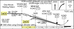
...and the math doesn't have to be as complicated as 318. using 300 (or 3) approximates it enough to tell you. For example, this is the ILS 3 into CHO (Charlottesville, VA).
IF at 3400, PFAF 2600. That's 800' to lose. 8÷3 is less than 3. That means less than 3 nm is needed to get down on a 3° slope. We have almost 7. Remaining at 3400 we will definitely capture from below. (You can also do it in reverse by multiplying the distance by 3).

I used to do this quick calc as a reality check, so it's become almost second nature, although when there's an IF, it is designed to be no more than a 3° path to the PFAF anyway.

1704049058239.png
 
In reality I always just use 300'/nm for a 3 degree glide slope.In the example you attached, for example, and assuming the controller has left me at 3500' when the clearance is issued, one knows that one should see the GS centered about 3500-2600 = 900'/300' = 3 miles away from SIPME (more or less). Your check on capturing from below is nice as well, though truthfully worry very little about that now since 95% or more of the approaches I make are RNAV/GPS.
 
In reality I always just use 300'/nm for a 3 degree glide slope.In the example you attached, for example, and assuming the controller has left me at 3500' when the clearance is issued, one knows that one should see the GS centered about 3500-2600 = 900'/300' = 3 miles away from SIPME (more or less). Your check on capturing from below is nice as well, though truthfully worry very little about that now since 95% or more of the approaches I make are RNAV/GPS.
You and I are on the same page with the quick calculation. Also with flying RNAV/LPV as opposed to ILS except for practice (unless I have to).

Yes, I sometimes do the "I'll intercept about 3 miles from..." but mostly it's just an anticipatory check that at this altitude I'll be below when the GS or GP comes alive.

Perhaps funny side issue. If you've come across discussions of "transition to approach" being on or off in the GFC500 and 600, it's mostly about different stabilized descent methods (on=VNAV all the way to the PFAF; off=maintain the IF altitude until capture), neither of which are dive and drive.

Yes, both settings will result in essentially the same vertical path from the IF altitude to the PFAF and GS/GP intercept. The TOD for using Baro-VNAV is delayed to be the point where the aircraft arrives as the PFAF at the intercept altitude. The Baro-VNAV path is temperature compensated so that the GS/GP that is fixed in space will still allow capture of the GS/GP smoothly. Otherwise, on a hot day where the indicated altitude is lower than the true altitude, the Baro-VNAV path would leave the aircraft above the GS/GP requiring an intercept from above. With temperature compensation, this puts the Baro-VNAV GP on essentially the same vertical path as the WAAS LPV GP path or ILS GS path, so switching to GS/GP should be seamless.

This is from the GTN Xi STC IM:

Enabled: Vertical navigation will automatically adjust the descent path to compensate for temperature changes and provide a continuous descent onto the approach. The Transition
to Approach function requires a static air temperature input.

Disabled: Vertical navigation will end at the waypoint preceding the final approach fix (FAF) in the flight plan. Select this option when using a GFC 500 or non-Garmin autopilot.

NOTE: The Transition To Approach feature must be disabled when the GTN Xi is interfaced to a GFC 500 or third-party (non-Garmin) autopilot system.{/quote]

When we flew last year, the setting was enabled and should not have been since I have an Stec 60-2.
 
I’ve had endless conversations about transitioning to approach when occasionally flying a light jet from time to time. Lots of VNAV discussions! I know what you speak of.

The other place the 3*300=900-1000’ comes in is when using the Garmin visual approach feature in the newer boxes. At an unfamiliar field, will often go direct to the synthetic 3 mile point on final it creates, aiming to be about 1000’ above field elevation when get there. Obviously terrain has to be factored in independently since it’s not a full instrument approach.
 
NOTE: The Transition To Approach feature must be disabled when the GTN Xi is interfaced to a GFC 500 or third-party (non-Garmin) autopilot system.
I have a friend who flies with it enabled with a GFC500. He says it works just fine. No one seems to know why Garmin says this about the GFC500. I'm planning on flying with the setup in the next few weeks and trying the same approach with both settings to see what it does.
 
I’ve had endless conversations about transitioning to approach when occasionally flying a light jet from time to time. Lots of VNAV discussions! I know what you speak of.

The other place the 3*300=900-1000’ comes in is when using the Garmin visual approach feature in the newer boxes. At an unfamiliar field, will often go direct to the synthetic 3 mile point on final it creates, aiming to be about 1000’ above field elevation when get there. Obviously terrain has to be factored in independently since it’s not a full instrument approach.
Which makes sense. A straight in is really just a normal traffic pattern stretched to a straight line.
 
This is an old post, but it still pops on Google as a top resource to address this question, so I'd like to add my $0.02. The OP was a new CFII looking to know what to teach his students. Being in a similar boat, I, too, had this question, and after careful research, I've come up with six reasons to teach technique #1 (dive & drive).

1) AIM 5-4-5(b)(4)(2) says the FAA intends you fly the approach using Technique #1. While it says "intends," and not "requires," it's the FAA offering official guidance. As a CFII, ensuring students know what is recommended is important.

2) Confirm your altimeter setting. Intercepting at the specified altitude is a good cross-check that you've got the right altimeter setting. If the GPS activates the final approach segment and you're not at the published intercept altitude, that would be the warning to cross-check your setting.

3) Confirm you are at the PFAF. With the slow demise of DME in the GA cockpit and the decommissioning of many markers, one of the few remaining ways to cross-check the magical GPS box is to use intercept altitude to identify the PFAF. If you ride the beam down from altitude, you will pass through intercept altitude but have no way to cross-check that you are at the fix and, therefore, on the "correct" glideslope (see point 4)

4) Confirm you are on the correct glideslope. Flying the ILS by hand, you're unlikely to be willing to maintain the dramatic pitch down needed to fly a 9-degree false glideslope, and you'd likely realize you'd made a mistake. But if you encounter a strong tailwind and are slow to configure AND you are letting the auto-pilot fly the approach, it's possible you might not notice you were on a false glideslope.

5) Step-down fixes. Some ILS approaches have step-down fixes between the IAF and FAF (i.e., DANDY at TEB). They may not be common, but they exist, and if you blindly follow the glideslope down from beyond the FAF, you could bust a required altitude (or worse).

6) Lower may get you under. It's rare to break out only at minimums. Dropping down when the approach permits might mean you get under the clouds sooner.

As I said, just my $0.02.

Some of my comments on your $.02.

1) True. The note states: "The ILS glide slope is intended to be intercepted at the published glide slope intercept altitude." It does not specify a technique such as descending to the minimum segment altitude immediately after crossing the IF.

2) Depends on the type of equipment being used. For an ILS or LPV, it is a reasonableness check. Depending on conditions of temperature, more than 120 feet of error is possible with a correctly set altimeter. If you are flying an aircraft that uses Baro-VNAV for the vertical on either a RNAV (GPS) procedure with an LNAV/VNAV minimums or RNAV (RNP) procedure, nothing is confirmed by being on the GP at the FAF since both the GP and the altitude will be off to the same degree of the improperly set altimeter, IOW the GP will move as well as the altitude indication. With VTF, the GP can be active beyond the intermediate segment leading to the PFAF, but when flying the full procedure, the GP does not display until past the last IF fix or stepdown before the PFAF. So when flying the full procedure there are no additional step down fixes when the PFAF is the active fix. The altitude on the chart is a minimum and is not a maximum. Most autopilots without VNAV support making the transition from the higher altitude at the IF segment minimum and will do a great job of intercepting the GP, just a little further out from and a little higher than the PFAF (500 feet higher is 1.7 NM). So I wonder where the autopilots that are VNAV capable set the TOD for the step down descent to the PFAF for GP interception, it is along the GP (especially when temperature compensated), so both VNAV capable as well as non VNAV capable follow essentially the same path, neither follow initiating the descent once crossing the fix that begins the segment with the FAF as the active fix. I guess they did not read the guidance.

3) This is not accurate, whether one is level at the PFAF or descending on the GP, a brief check of the altitude is as good a cross check. It is part of my standard check at the PFAF on the GP/GS. As previously mentioned in 2), this does not work as a cross check for a GP based on Baro-VNAV.

4) You are right, you would notice regardless if hand flying or using the autopilot. The false GS at 9 degrees is going to be at least +3000 feet higher at the PFAF and much more further out. A typical IF to PFAF segment is like 5 NM and 500 feet and if you are anywhere close to the PFAF altitude, like within 1000 feet, there is virtually no chance of encountering a false GS although your autopilot may have difficulty capturing a GS/GP from above.

5) True, the step down minimum altitude applies if it is outside the PFAF on a vertically guided approach.

6) True, but not a very relevant difference, if you are going to bust out at the lower altitude, in either case, you don't have a difficult approach, at least due to the conditions. Both will likely be 5+ NM to the runway and visual conditions.

I would teach either is acceptable with the caveats noted. In my Bonanza, I will be slowed down to an approach speed on the IF segment, and use the AP to intercept the GS/GP at the IF segment crossing altitude. I will just lower the gear to maintain the GS/GP and verify a reasonable altitude at the PFAF. Much simpler than multiple power changes to do the step down to the GS/GP intercept altitude.
This is an old post, but it still pops on Google as a top resource to address this question, so I'd like to add my $0.02. The OP was a new CFII looking to know what to teach his students. Being in a similar boat, I, too, had this question, and after careful research, I've come up with six reasons to teach technique #1 (dive & drive).

1) AIM 5-4-5(b)(4)(2) says the FAA intends you fly the approach using Technique #1. While it says "intends," and not "requires," it's the FAA offering official guidance. As a CFII, ensuring students know what is recommended is important.

2) Confirm your altimeter setting. Intercepting at the specified altitude is a good cross-check that you've got the right altimeter setting. If the GPS activates the final approach segment and you're not at the published intercept altitude, that would be the warning to cross-check your setting.

3) Confirm you are at the PFAF. With the slow demise of DME in the GA cockpit and the decommissioning of many markers, one of the few remaining ways to cross-check the magical GPS box is to use intercept altitude to identify the PFAF. If you ride the beam down from altitude, you will pass through intercept altitude but have no way to cross-check that you are at the fix and, therefore, on the "correct" glideslope (see point 4)

4) Confirm you are on the correct glideslope. Flying the ILS by hand, you're unlikely to be willing to maintain the dramatic pitch down needed to fly a 9-degree false glideslope, and you'd likely realize you'd made a mistake. But if you encounter a strong tailwind and are slow to configure AND you are letting the auto-pilot fly the approach, it's possible you might not notice you were on a false glideslope.

5) Step-down fixes. Some ILS approaches have step-down fixes between the IAF and FAF (i.e., DANDY at TEB). They may not be common, but they exist, and if you blindly follow the glideslope down from beyond the FAF, you could bust a required altitude (or worse).

6) Lower may get you under. It's rare to break out only at minimums. Dropping down when the approach permits might mean you get under the clouds
So I found a reason #7 which is sure to make everyone agree (grin)

JO 7110.65, section 3-7-5 that discusses protecting the ILS critical areas. There are some weather mins, but it also says it will only be protected when an air aircraft is within the outer marker. So following the glide slope early will lead all approaching aircraft to the fuel farm or to the airport coffee stop and not the runway.

(May have ad-libed the fuel farm). But the point about ILS protection only when your inside the marker is true.
a. It’s only needed inside the FAF, and
b. An unprotected localizer outside the FAF is what‘s generally being used for dive and drive navigation.
 
Anybody know of any research that has been done pertaining to accidents caused by intercepting false glideslopes? I've been hearing that warning for decades, but the actual risk of this happening seems to be almost vanishingly small. I mean, at twice the angle it's "reversed", which would look weird, and at three times the angle it's "correct" but you'd be literally 3 times the AGL altitude at any given point and therefore require 3x the descent rate (so, like 1500 fpm in a 172), which is bound to get your attention.

If this is actually a problem, I'd be really interested to read some accident reports (or ASRS, ASAP, etc reports).

I'd hypothesize that if this is actually a problem, it was many decades ago, before GPS and DME and RADAR service and other distance-remaining indicators. As in, just flying final with no SA on distance until the glideslope needle starts coming down.

EDIT - We'll I'll be...


Short version is that the crew was way high, trying to intercept the glideslope from above, and crossed the FAF 500 ft above the published altitude. Therefore, the autopilot did not capture the GS. But they also had the altitude preselect set for 200 ft above the FAF altitude (their last cleared altitude), so after passing the FAF and not capturing the GS, the autopilot leveled off at that altitude and flew level until the 9 deg false glideslope.

The article is confusing, though. It mentions that the 9 deg glideslope is reversed, which is not true, and that the autopilot commands would therefore be backward. The aircraft upon encountering this glidepath pitched up dramatically, which I don't understand either. With a 9 deg glideslope it should have pitched down, just steeper.

If they meant the 6 deg false glideslope, though, when I draw it out in my mind it should still command a descent, as approaching the 6 deg glideslope from below, the needle would be full-scale down, right? And then it would come up to meet you as you fly level towards the false GX intercept.

Spoiler alert, they executed a go-around and returned for a safe landing.
Yeah. It’s called Die Hard 2. Old aviation documentary.
 
So I found a reason #7 which is sure to make everyone agree (grin)

JO 7110.65, section 3-7-5 that discusses protecting the ILS critical areas. There are some weather mins, but it also says it will only be protected when an air aircraft is within the outer marker. So following the glide slope early will lead all approaching aircraft to the fuel farm or to the airport coffee stop and not the runway.

(May have ad-libed the fuel farm). But the point about ILS protection only when your inside the marker is true.
7. Is not a valid new reason that applies to aircraft outside the PFAF. The concern is for the final stages of the approach, not far out on the IlS beyond the PFAF where a DND or following the ILS GS technique might be used. It also has no relevance to RNAV (GPS) with LPV, LNAV/VNAV minima or RNAV (RNP) approaches.

This is part of the current pilot guidance in the AIM 1-1-9(k.) ILS Course and Glideslope Distortion:

4. Pilots are cautioned that even when the critical areas are considered to be protected, unless the official weather observation including controller observations indicates a ceiling less than 200 feet or RVR less than 2000 feet, ATC may still authorize a preceding arriving, departing, or missed approach aircraft to pass through or over the localizer critical area and that this may cause signal disturbances that could result in an undesired aircraft state during the final stages of the approach, landing, and rollout.
 
So I found a reason #7 which is sure to make everyone agree (grin)

JO 7110.65, section 3-7-5 that discusses protecting the ILS critical areas. There are some weather mins, but it also says it will only be protected when an air aircraft is within the outer marker. So following the glide slope early will lead all approaching aircraft to the fuel farm or to the airport coffee stop and not the runway.

(May have ad-libed the fuel farm). But the point about ILS protection only when your inside the marker is true.
The 7 in 3-7-5 is a Section, Taxi and Ground Movement Procedures in Chapter 3, Airport Traffic Control. It has nothing to do with this subject. ILS Critical Areas are only enforced when the Ceiling is less than 800 or Visibility less than 2.
 
Back
Top