Garmin vs Jeppesen Revisited WHICH ONE IS BEST AND CHEAPEST?

Flying Doc

Pre-takeoff checklist
Joined
Jun 5, 2020
Messages
177
Display Name

Display name:
FlyingDoc
Looking at pricing to update the GNS530W (IFR Use) and the GNS430 on my new plane. I have never had to do the database updates. Ive seen the discussions over the years but its been a while so wanted to see what the latest oppinion is. Strange thing is that my plane came with the Jeppesen dongle but when I pulled the cards out they were Garmin (both Terrain and Other data). Ive read that the Data Cards can story eithr Garmin or Jeppesen data...you just need right dongle.

So I am left to decide Garmin or Jeppesen data?
I have the Jeppesen Dongle so I would save $70(no garmin dongle needed) if I stayed with them.

Prices are a bit tricky on both sites.

Nav,Obstacle and Terrain on Garmin is $799 for both devices(combo deal).

Jepp would not quote me a combo online because it said the GNS430 has active subscription. But its not under my name so I cant imagine I can use it. Gonna have to call them. But they are already annoying buy not letting me price what I need, just to compare.
 
cheapest is usually garmin. Jeppesen is almost always more expensive than Garmin. Best - that is a personal opinion. Both will do what you need to do obviously. Some prefer Jeppesen charts (IFR approach plates) because they are used to it and they are generally easier to read.
 
There are differences in the database. One is that Garmin gives you LOC only option on an ILS or LOC. Jepp gives you ILS only with no LOC step downs inside the FAF. Another is the way they handle DME arcs. Not a big deal but different.
 
Garmin runs bundle specials at Oshkosh and SnF that may give you more value, esp if you also use the Garmin Pilot app.
 
Garmin runs bundle specials at Oshkosh and SnF that may give you more value, esp if you also use the Garmin Pilot app.
I use Foreflight. But darn OSH is long ways away. Need to find a discount code :). I am not cute enough(theid pay me not to) to represent them no matter how many pics I take with my plane on tictoc or youtube :) :) wearing garmin watches etc.
 
There are differences in the database. One is that Garmin gives you LOC only option on an ILS or LOC. Jepp gives you ILS only with no LOC step downs inside the FAF. Another is the way they handle DME arcs. Not a big deal but different.
Hope I dont have to do DME arcs anytime soon.
So the GNS530W wont jump to autoselect ILS and or to LOC(Magenta). Confused here.
 
cheapest is usually garmin. Jeppesen is almost always more expensive than Garmin. Best - that is a personal opinion. Both will do what you need to do obviously. Some prefer Jeppesen charts (IFR approach plates) because they are used to it and they are generally easier to read.
I use foreflight charts..dont plan on using the unit for that. Also I found out Jeppesen does not provide any Terrain or Obstacle data. That to me is the deciding factor.

Jeppesen: "AMERICAS" annual package for two units(GNS530W, GNS430) NAV only $720 USD.
GARMIN "AMERICAS" annual package (plus Terrain plus Obstacle) $799 USD. So for 80 bucs get the more important obstacle data. (I realize prob dont need either but 80 is cheap.)
 
Do what you need to do now, and then they give credit or pro-rate so you don't lose out on anything.
Nice. But ughhh I just found out that Garmin does not provide updates for the GNS430(NON WAAS). SO I have to pay jeppesen for that update....at this point then its cheapr for me to stick to Jeppesen.

Frustrating. WTF Garmin. Another company updates your hardware but you cant. What a POS
 
Hope I dont have to do DME arcs anytime soon.
So the GNS530W wont jump to autoselect ILS and or to LOC(Magenta). Confused here.
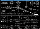
ILS OR LOC. Here’s an example. I don’t know where you are or I’d find an example in your neck of the woods.

This is the ILS or LOC Z 3 into my home base, TTA. Note the LOC only step down at AMIRS. When you load the ILS approach from either database, AMIRS does not appear in the sequence since it’s irrelevant to the ILS.

In addition to the ILS, the Garmin database has second entry for the LOC version so you can fly it to the lower minimum in case of a GS failure. The Jepp does not.

Just pointing out the difference, whether you care about it is a completely different question. I suspect most pilots would not.

1702986021759.png
 
Garmin nav databases are $299 for full US coverage. When I was with Jepp, I paid more than that for just Eastern US coverage. So Garmin it is for me for updating my GNS430W. The price gap narrows slightly if you go full package (nav, obstacle, terrain). One can save a bit by updating the obstacle or terrain databases on a less frequent basis, say every few years. These are not required to fly instrument approaches. For the GNS-430W, I recall there have been frequent issues of terrain card corruption when trying to update the terrain or obstacle data. I don't know if those issues are fully resolved, but if the update fails you have to get a new terrain memory card.
 
but if the update fails you have to get a new terrain memory card.
Has anyone tried cloning the card? I've done that successfully with G1000 data cards using but I know there are issues with the GNS cards that are different from the G1000 and GTN.
 
Three years ago I renewed my Jepp database. Is sent the check, they cashed it but it did not get cretiied to my account. I wrote and called. In that siutaiton I'm sure not going to send them ANOTHER $500. Been with Garmin ever since; about 8 months later they found by payment and offered to tuem me back on. "NO WAY!!"
 
Has anyone tried cloning the card? I've done that successfully with G1000 data cards using but I know there are issues with the GNS cards that are different from the G1000 and GTN.
These are not SD or microSD cards, but rather proprietary memory card units using 1990s technology. I don't know how you would format them.
 
Shades of grey. Slightly different flavors, slightly different prices. I favor Jepp just out of long-time familiarity, but that’s the only reason, really.
 
These are not SD or microSD cards, but rather proprietary memory card units using 1990s technology. I don't know how you would format them.
Ah! I didn’t realize the GNS cards themselves are physically different. Not the same as later avionics.
 
20 years ago favored Jepss over Gov charts. With the updates in formatting to the latter, no real difference in my humble option, and with FF, some of the stuff that Jepps used to collocate with the charts is now a link away, so less important than it once was.

AFAIK, the data are the same, it's just compilation and presentation that differ ever so slightly.
The charts is a subject all to itself. But it sounds like the question is about which GPS navigation data source for avionics to use, not which charts to purchase.

(FWIW, I agree with you about the charts with one exception - georeferenced Jepp SID and STAR.)
 
ILS OR LOC. Here’s an example. I don’t know where you are or I’d find an example in your neck of the woods.

This is the ILS or LOC Z 3 into my home base, TTA. Note the LOC only step down at AMIRS. When you load the ILS approach from either database, AMIRS does not appear in the sequence since it’s irrelevant to the ILS.

In addition to the ILS, the Garmin database has second entry for the LOC version so you can fly it to the lower minimum in case of a GS failure. The Jepp does not.

Just pointing out the difference, whether you care about it is a completely different question. I suspect most pilots would not.

View attachment 123402

This used to be true, but it appears that there are both separate ILS and LOC procedures currently in the Jeppesen Navdata. It may still be true for a world wide coverage, but I verified this on Jeppesen with the Americas Navdata, covers North America and South America and Caribbean.

There are a fair number of differences on SIDs and some STARs, in particular how Garmin often requires the runway be specified when Jeppesen does not. This messes up matching the SID as known by the panel equipment verses the EFB. ForeFlight uses Jeppesen in the EFB, Garmin uses Garmin. If they match the supplier for the panel, all is good, but if there is a mismatch, then some of these procedures won't transfer from EFB to panel. Usually the other direction is more tolerant.
 
Back
Top