Steve I'm looking at the sectional chart now and I don't notice any difference in quality compared to what it looked like before the update.
You might look at you map settings...From map screen...General..."Improve Map Performance". Make sure this is OFF. I just turned mine ON and it definitely reduced the map quality!! I turned it back OFF and it looks great again.
Chris,
I should have mentioned that in my previous post, but yes I checked that setting earlier and it is set to OFF.
Matthew said:
Nexus 7 here.
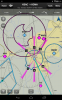
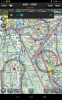
I think I see what you are talking about, but it only shows at certain zoom levels. Probably has something to do with pixel resolution
I took a screenshot at the same setting and location you have. See if you can see similarities.
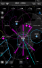
Matthew, yes I can see similarities in the screen shot you posted, it looks pretty bad too. If you look at the comparison screen shot I posted that I took with 2.8.1, all the labels are clearly legible at that same zoom setting, yet in 3.0, they are not.
If I zoom in all the way, so there is no pixel scaling, then both 2.8.1 and 3.0 appear equal in quality. Obviously when I zoom way far out, you can't read anything on either version. But there is a whole range of zoom levels (the ones that, honestly, are the most practical for inflight use IMHO) which were clearly legible in 2.8.1 and unusable in 3.0.
So I don't think the underlying map quality has changed (also, I'm not re-downloading the charts when I switch between versions so they really should be the same underlying files) but rather the algorithm used to scale the charts when they are zoomed out. Almost like the 3.0 version has anti-aliasing turned off, or something like that.
Based on your screenshot, it appears that others can see this problem as well. But based on the other replies, it sounds like perhaps the problem is less noticeable or maybe occurs less frequently on other devices than on my own.
Thanks, guys. I've opened a ticket with Garmin support this morning, so we'll see what they say.
Steve
")