
Garmin Flight Charts for IFR Training?

NordicDave

En-Route
Joined
Oct 31, 2015
Messages
2,737
Location
Monterey County
Display Name
NordicDave
Home Airfield
KWVI
I have a G3X and GTN-650Xi installed in my panel. VFR pilot considering IFR training soon.

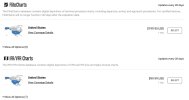
Question: What's the difference between the 2 Garmin option below for IFR flying? I appreciate the help.
Untitled 2.jpg
 
FliteCharts are approach procedures -- the ILS 12 at KABC, the GONZO departure, etc. IFR/VFR charts are the actual charts of the US, like a sectional or IFR low enroute chart -- it's Skyvector on your panel.

For a G3X + GTN650 (or GNX375 or GPS175) combo, my recommendation is to buy:
1) The US IFR Bundle for the G3X, which will get you nav data, IFR/VFR charts, FliteCharts, terrain/obstacles, and airport data. The big screen on the G3X is where you want to be using these more graphical products.
2) US Nav Data only for the GTN650, which gets you the approach data you need to be legal.

This combo runs me $450/year and both keeps me in legal data and gives me all of the nice-to-have products on the G3X.
 
As mentioned, they are two different products.

Flite Charts are duplicates of FAA instrument terminal procedures (approaches, departure information, etc) and Chart Supplement material.

IFR/VFR Charts are duplicates of FAA Sectionals and IFR enroute charts.

Opinion: In theory, you don’t “need” either if you are using paper charts or an EFB. But the integration of that material, particularly the IFR/VFR Charts in the G3X is excellent and you may end up leaving the tablet closed once in the airplane.
 
Do you have an iPad/EFB? Not sure of the screen resolution on G3X, but on my G500 FliteCharts were pretty much illegible. I dropped FliteCharts in favor of using approach plates on my iPad with Garmin Pilot. I use the US standard One Pak. The cost is $799 and it covers GTN 650, G500 (similar to G3X) and my comm 2 radio that has frequency data. It also gets me GP premium for free. (have to pay for basic ~ $100). GP premium has approach plates, and IFR high/low charts.

What are you already buying from Garmin for your nav data?
 
Much better on the G3X from what I’ve seen.
I would guess the touch screen also makes them easier to manipulate. Trying to zoom and move with knobs on the G500 (non-txi) made me regret purchasing the plates pretty much instantly.
 
I would guess the touch screen also makes them easier to manipulate. Trying to zoom and move with knobs on the G500 (non-txi) made me regret purchasing the plates pretty much instantly.
Definitely. Basically, it's like having an integrated EFB except if you like to annotate the charts.
 
Guys, Thank you a ton for the help! Originally the panel new panel last year came with the full Garmin data package including Flight Charts. They were quite readable on the G3X. Just had a difficult time segmenting what data product was what.

BTW, screen resolution on both the 10" G3X and G500TXi is 1280 pixels (W) x 768 pixels (H). However the G500TXi has an even finer dot pitch for another level of crispness of display.

A long retired CFII looked at my panel compared to round gauges and charts or just an EFB on the knee and say "Wow, this is just straight-up cheating". :biggrin:

The capability is amazing!
 
A long retired CFII looked at my panel compared to round gauges and charts or just an EFB on the knee and say "Wow, this is just straight-up cheating".
You may discover it's really not. It is somewhat true when we talk about hand flying, but that's the smallest (although essential) part of instrument flight. The infamous "children of the magenta line" aside, when instrument approach capable GPS came along, people said that flying with it was easier but setting it up more difficult. As the these have become better, they have also become more complex. That "amazing capability" means more opportunity for errors, and a whole bunch of pilots who don't know how to use the equipment beyond a very rudimentary level - and that includes pilots who earned their instrument rating with the equipment.
 
The data costs being quoted here are obscene. We desperately need market competition to Garmin.
 
The data costs being quoted here are obscene. We desperately need market competition to Garmin.
Jeppesen :D Besides, no one said you had to get a G3X or other Garmin combo PFD/MFD even if you stuck with Garmin, so you can skip the Flite Charts entirely.

You can also go with a Dynon panel. For IFR, you’d still need an external GPS navigator/FMS, so you’d still have the compatible database cost (so far, anyway), but the chart bundle - sectionals, enroute, approach plates, georeferenced airport diagrams, etc - is less than $120 annually
 
Last edited:
I get a One Pak. This covers all the databases in a single airplane (I have G3X plus 750 and 650).

It also include Garmin Pilot Premium (you still have to buy the Basic) and also includes one handheld device (I have an AERA 760 that I was going to put in a dock).
 
I get a One Pak. This covers all the databases in a single airplane (I have G3X plus 750 and 650).

It also include Garmin Pilot Premium (you still have to buy the Basic) and also includes one handheld device (I have an AERA 760 that I was going to put in a dock).

Annual price?
 
I think I paid like $350 or something for a year of Jepp nav charts to be legal for IFR. Garmin had all the other fancy options too but I figured it was unnecessary when you have an EFB
 
I pay about $1000 for Garmin data for my GTN750Xi, G500TXi, and AERA795. I get the Americas One Pak and it includes all the Americas with US/Canada and Brazil approach charts. If you just buy the US, it is much cheaper, cheaper again without the approach charts.
 
I get the GTN 6XX United States (Fixed Wing) Database Bundle $499 and the G3X US Database Bundle for $149.95 so a total of $648.95. I also have the GarminPilot premium sub and use that for plates 99% of the time so I could drop the G3X annual sub for one-time updates for various single updates vs the bundle and save a little but I like have everything up to date and Flight Charts as a backup to my EFB.
 
The data costs being quoted here are obscene. We desperately need market competition to Garmin.
Garmin *is* the competition. We used to have to buy the data from Jeppesen! Garmin's prices are pretty much always lower, even when you buy a whole bundle of databases instead of just the navigation data.
 
But not the shock. Almost a thousand bucks a year for the one paks. Holy moly!
Add the frustration of having to buy the same data multiple times over. After I give Garmin their pound of flesh to keep my GTN750 more useful than a boat anchor, I have to pay for the same charts on my Aspen MFD so it has all its chart-map overlay features...then for good measure, there is the requisite Foreflight subscription, which of course includes charts. Nearly $1,500 a year for the same data set three times.
 
Add the frustration of having to buy the same data multiple times over. After I give Garmin their pound of flesh to keep my GTN750 more useful than a boat anchor, I have to pay for the same charts on my Aspen MFD so it has all its chart-map overlay features...then for good measure, there is the requisite Foreflight subscription, which of course includes charts. Nearly $1,500 a year for the same data set three times.
That is because you have a mixed race airplane. :D :D

My panel is all Garmin. They sell a One Pack, which updates every box in my airplane, plus one portable device (I have an AERA 760) AND give Garmin Pilot Premium upgrade.

I do also have ForeFlight, but as a CAP pilot I get that for free.
 
Back
Top