Garmin Databases

BeechSundowner

Filing Flight Plan
Joined
Oct 1, 2023
Messages
29
Display Name
BeechBum
Hi all, I am finishing a Garmin GPS 175 install in my RV and just had a look at database prices. Nav Data is $299, where as the package with terrain, safe taxi, obstacles, etc is $499. This is my first garmin and my Avidyne already had those databases installed from a prior owner, I just kept up with the Nav Data updates.

I see the benefit to having terrain and obstacles, but have you found it necessary or is the $299 Nav Data good enough. Will be flying IFR
 
I buy the whole package, flying both VFR and IFR. An extra $200 isn't much in the scheme of how much it costs to fly and I've found that the information is useful, particularly the safe taxi charts at an unfamiliar airport. Perhaps pull the package trigger for one year and see for yourself if it's useful? If it doesn't meet your needs, you could scale back.
 
I see the benefit to having terrain and obstacles, but have you found it necessary or is the $299 Nav Data good enough. Will be flying IFR
Terrain is only updated “as necessary”. The current one is already several years old, so no need for that to be on a subscription.
 
I bought the terrain/obstacles/safe taxi database once. No need to buy it every year. Towered airports have FAA diagrams available under Procedures, and untowered airports aren’t that complicated.
 
I don't buy the obstacle and terrain updates. I don't find it to be particularly useful for where I fly. Perhaps in a more mountainous area it would be useful.
 
I don't buy the obstacle and terrain updates. I don't find it to be particularly useful for where I fly. Perhaps in a more mountainous area it would be useful.
The really tall towers tend to get built in the flatlands more often than the mountains.

Terrain usually doesn't move very often, which is why that database is not regularly scheduled. Even then, it's usually in the downward direction and not the upward direction (e.g. when Mount Saint Helens lost its top).
 
If the optional data is useful is really defendant on your missions. If I was flying pipeline patrol in marginal VFR, it would be a really useful data. Flying hard IFR, it might be really useful data in the event of an engine failure and emergency off airport landing.
 
It also depends on your avionics. If you are flying a GI 275 or one of larger panel displays, you'll need the database for synthetic vision.
 
The really tall towers tend to get built in the flatlands more often than the mountains.
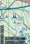
I've found that to be true also. The two biggest towers I've encountered (at least that I've been aware of) are on the Colorado plains and south of Raleigh NC. The locals call the Raleigh area one, "scary tower." When the Denver one went up, the stability wires were so far out we gave it a very wide berth.


1784125454211.png
 
Back
Top