Garmin 530 with MX20 Setup – External GPS settings

mrcshbs

Pre-Flight
Joined
Apr 29, 2019
Messages
36
Location
Saint Louis, MO
Display Name

Display name:
Marcos STL
Hello all,


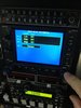
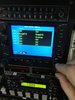
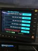
I would like to ask some of the experts here at POA. This may be a simple. This is a bench test setup for now. But I am having an issue setting up the Garmin 530 non WAAS with the MX 20 MFD. I had this MX20 for a while and never got to play with it much.


This is the setup:


Garmin 530 Serial # 3 is connected to MX20 on serial # 1. I also have a Garmin Flight stream 210 connected to serial port # 2 on GNS 530, however, since this is a non WAAS, I can’t transfer flight plans AFAIK. Currently, the MX20 won’t display the map, even though the external GPS is connected.


Questions:

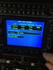
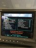
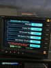
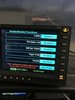
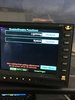
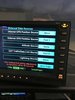
1: What are the serial output settings on the Garmin 530 to output position to the MX20?

2: What are the settings on the MX20 to connect to the external GPS of the 530? I have it setup on Serial # 1 on the MX20 to receive the GPS data, does the NAV is also on serial # 1?

3: Even though the Flight Stream may not work, what are the serial settings on the 530 to talk to the Flight stream 210?


Any input is appreciated it.
 

Attachments

  • IMG_6138.JPG
    IMG_6138.JPG
    230.2 KB · Views: 16
  • IMG_6139.JPG
    IMG_6139.JPG
    214.6 KB · Views: 15
  • IMG_6140.JPG
    IMG_6140.JPG
    232.8 KB · Views: 14
  • IMG_6141.JPG
    IMG_6141.JPG
    221.3 KB · Views: 14
  • IMG_6142.JPG
    IMG_6142.JPG
    225.7 KB · Views: 14
  • IMG_6143.JPG
    IMG_6143.JPG
    228.9 KB · Views: 14
  • IMG_6144.JPG
    IMG_6144.JPG
    210.3 KB · Views: 14
  • IMG_6145.JPG
    IMG_6145.JPG
    258.4 KB · Views: 16
  • IMG_6146.JPG
    IMG_6146.JPG
    222.7 KB · Views: 14
  • IMG_6147.JPG
    IMG_6147.JPG
    243.1 KB · Views: 15
Here are some additional pics.
 

Attachments

  • IMG_6148.JPG
    IMG_6148.JPG
    239.5 KB · Views: 15
  • IMG_6149.JPG
    IMG_6149.JPG
    254.3 KB · Views: 15
  • IMG_6150.JPG
    IMG_6150.JPG
    256.6 KB · Views: 13
  • IMG_6151.JPG
    IMG_6151.JPG
    207.5 KB · Views: 13
  • IMG_6152.JPG
    IMG_6152.JPG
    222.3 KB · Views: 13
  • IMG_6153.JPG
    IMG_6153.JPG
    232 KB · Views: 13
  • IMG_6154.JPG
    IMG_6154.JPG
    257.5 KB · Views: 14
  • IMG_6155.JPG
    IMG_6155.JPG
    268.1 KB · Views: 12
What software version do you have on the MX20? Which port is the 530 connected to?
If your 530 is outputting Aviation 1 or MapMx, you need ver 5.6 or later on the MX.
If it's outputting Aviation 2, or MapCom, the MX can use ver 5.5 or earlier

Then you need to check the port configs on the MX.

Edit: looks like you 've got ver 5.7., and your outputting aviation on port 3 of the 530. Is your 530 port 3 connected to the port 1 of the MX?
 
Last edited:
The Data port configs on the MX should be:
No internal GPS
External GPS position source. port 1
To get to the MX install page:
Turn the power on
Immediately after the self-chrck, press buttons 1,4 and 6 in sequence.
Then press the function key until you see the instl soft key.
 
You said the 530's on a bench, but your photo shows it in a panel. Do actually have satellite lock on the bench? Have you put a flight plan into the gps to see what happens?
 
The software version on the MX shows 139.0182.057V5.7. That's what is showing on the boot screen. The port 3 on 530 is connected to port 1 on the MX. I have verified the pins and they are connected. That's what I think it's so weird.

The settings I have on the MX are: none for the "GPS internal" and "External GPS" I have it set to port 1. I have OK signal. The 530 shows my current position and picks up satellites reasonably fast.

Any ideas?
The fact that the "POS" flag isn't showing means that the MX20 is receiving something from the 530. However, it's not clear from the documentation whether that means the MX20 is able to interpret the input. A couple things to try would be to activate a flight plan or enter a direct-to destination. I know a quirk of some GPS from that era was that moving maps wouldn't display without a destination or waypoint and I don't know if the non-WAAS 530 falls into that category. Another thing to try would be to play with the 530's output format. Try switching it from "AVIATION" to "MAPCOM" or "MAPMX". Again, not sure what options are available on a non-WAAS GNS as those are somewhat rare these days.
 
The fact that the "POS" flag isn't showing means that the MX20 is receiving something from the 530. However, it's not clear from the documentation whether that means the MX20 is able to interpret the input. A couple things to try would be to activate a flight plan or enter a direct-to destination. I know a quirk of some GPS from that era was that moving maps wouldn't display without a destination or waypoint and I don't know if the non-WAAS 530 falls into that category. Another thing to try would be to play with the 530's output format. Try switching it from "AVIATION" to "MAPCOM" or "MAPMX". Again, not sure what options are available on a non-WAAS GNS as those are somewhat rare these days.

My MX20, software ver. 5.7 aviation format RS232 data from a Garmin 175 will not display until a destination waypoint is entered on the GPS. Neither would it when driven by a GX50 rs232 MapCOM .

The last three positions on your version number, v5.7 tells you it'ts 5.7. You can confirm that by looking at the data card sticker. So you should be ok with aviation data.
 
Last edited:
I have an update. update. asicer was correct. It does nothing when you start, but when you load a flight plan, the MX 20 displayed my position. I was not able to fly it and test it further because it's not really connected (just a cable for now), but looks like aviation setting on the serial may work, but you have to "give it a start" like loading a flight plan. Maybe when moving the airplane it will kickstart the MX20.

Quick update: I connected a flight stream 210 to serial port 2 on the GNS 530 (non WAAS). I know you will need a WAAS to transfer flight plans between foreflight and 530. What are the settings on the serial on the 530? can anyone share?
 
What are the settings on the serial on the 530?
What are the possible options? Since the FlightStream is designed for broadcasting GPS position and for flight plan transfer, I'd imagine it would be one of MapMx, MapCom, Aviation or Connext
 
Back
Top