Perezhr
Pre-takeoff checklist
Okay, find KCVK on the sectional in ForeFlight for me and post the screen shot here. I'll wait.
Interesting. I have never noticed that.
Sent from my iPad using Tapatalk HD
Okay, find KCVK on the sectional in ForeFlight for me and post the screen shot here. I'll wait.
care to post a screen capture? I let my foreflight lapse when we moved out of its coverage areaInteresting. I have never noticed that.
Sent from my iPad using Tapatalk HD
you are right that is an issue, but I'll bet if you drop them a note it will be fixed in a couple weeksJeff,
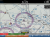
The paper sectionals are literally overlapped and scanned. CVK is shown on the St. Louis sectional but not on the little rock. Little rock is on top, so CVK is buried "under the overlap". The airport symbol, all the info, everything. It's all missing. The magenta ring is there, but that's it. I'll see if I can get a screen shot (got it, it's attached).
It's not the only one out there either. It's just the one closest to me that I'm the most familiar with...just like Flippin's missing info under the overlap.
you are right that is an issue, but I'll bet if you drop them a note it will be fixed in a couple weeks
IMO it is the loss of information at the "overlaps" of sectionals. One example: the Flippin AR (FLP) airport info is completely lost "below the overlapping sectional". Numerous other examples of this can be found "around the edges" of sectionals everywhere. I brought this to their attention long ago, but maybe there is nothing they can do about it.
But many of us hate Jepp...on numerous levels and fronts.
If that's the biggest flaw in ForeFlight, I can live with it, since there are a lot of ways to pull the information up besides the data block on the sectional.

Jeff,
The paper sectionals are literally overlapped and scanned. CVK is shown on the St. Louis sectional but not on the little rock. Little rock is on top, so CVK is buried "under the overlap". The airport symbol, all the info, everything. It's all missing. The magenta ring is there, but that's it. I'll see if I can get a screen shot (got it, it's attached).
It's not the only one out there either. It's just the one closest to me that I'm the most familiar with...just like Flippin's missing info under the overlap.
I think I can fairly sum up this thread with:
ForeFlights biggest flaw is that it doesn't do everything I want it to! Right NOW!


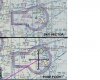
Oh, and if anyone hasn't seen the new not-scanned sectional format: http://wms.chartbundle.com/charts/t...6.8146&lon=-13189246.60429&layers=000000000B0
Wow, I had not seen those before. Looks great! Cluttered still, but much more legible, almost like it's vector-based text.
Wow, I had not seen those before. Looks great! Cluttered still, but much more legible, almost like it's vector-based text.
I wish the menu bar on the bottom of the screen ( to navigate between FF main pages) were relocatable to the top of the screen I use my ipad in portrait and the buttons on the top of the screen are simply easier to accurately get to, whereas I miss the buttons along the bottom quite a bit.
The good news is that the new FAA charts will look better.
Those are pretty!
I wonder if they will require more storage within Foreflight, when they become available.
My beefs are:
1. Lack of audible terrain warning.
2. Flight plans not synced between iPad and iPhone.
3. Lack of VNAV features
Well, I'm sure they are vector based behind the scenes. But the FAA is providing them as TIFF raster files just like before. However, since the colors are much smoother they do seem to compress better. A quick comparison on the FAA samples show that even at the higher resolution the compressed TIFF source files are slightly smaller. (69MB new vs 88MB old for Los Angeles)They look perhaps vector based. Might take _less_ storage.
Inability to store flight plans in the cloud and download them to multiple devices
Limitation to only 2 devices...should be at least 3: iPad, iPad back-up, and iPhone.
1. No "Set 'OBS' and Hold" (Actually prefer "Set 'Radial' and Hold", but I digress)

2. No NRST option
3. If one has a flight plan entered and you select the Airport Icon, I think it should display either your Departure Airport or your Destination AP (whichever you're closer to at the moment) by default. I would bet that is the information the pilot is looking for 90% of the time.
4. No Split Screen
5. They haven't incorporated CheckList Pro into FF as a selectable Icon at the bottom
What is it you're trying to do, exactly? You can create a route from a radial/DME fix directly to the VOR to get a line on the map if you want that...
Example: OSH225015 OSH (or OSH/225/015 OSH)
Does that do what you want it to?
Oh, and if anyone hasn't seen the new not-scanned sectional format: http://wms.chartbundle.com/charts/t...6.8146&lon=-13189246.60429&layers=000000000B0

Add to the "Wish List" the ability to set alerts, i.e. alert me 40 miles northwest of MSP or 1 minute before PANIC intersection. I use that feature in Garmin Pilot and wish FF had it.
YOU ARE A FLIPPIN' GENIUS!!!! THANK YOU!!!
Now, what is the HUD (head Up Display, right?) I don't know how to access that in FF.
If I had such a software from someone other than jepp which covered my corner of the world, I would give thanks for it and not nitpick the edges of the paper.
IMO it is the loss of information at the "overlaps" of sectionals.

Is your real name "Manfred"?♫ mama always told me not to fly onto the edge of the map...but mama...that's where the fun iiiiiiiiis ♫
You might be the first person I have ever seen that prefers gov charts.