Foreflight feature request

The ability to find routes automatically is pretty non-existent beyond go direct.
I'm not sure I understand what you mean.

I know that FF, for example, allows me to enter a route than include SIDs, STARs, Victor airways, etc. What kind of "automatic" route-finding are you talking about?
 
Why does it work this way? Well, Jason hit the nail on the head. Battery life. The way iOS works, allowing only limited background functionality with fast app switching and state-saving, allows it to do almost everything that a less-restricted OS can do, while drastically improving battery life. Since the long-life battery is one of the things that makes the iPad truly great for a large number of applications (such as being an EFB ;)) I think Apple is doing the right thing.

Thanks for the explanation Kent. So, I request that Apple make it possible for such things to occur when your iPad is on WiFi and connected to a power source... as mine often is when it's sitting in my office charging at home. ;-)

If battery life and concern about downloading too much stuff over a limited 3G plan is truly the reason why they limit such functionality, it would be a relatively simple thing (from my perspective) for the iOS to waive normal download / multitasking / installing perspective when the device is connected to AC power and a fast WiFi connection.
 
Ok fine. I thought the thread was about features that users might want and I offered a function that would be nice to add. I like giving as much info in a PIREP as possible and having that calculation is a nice feature. It is also a good measurement to see if the forecast winds are what one is actually in or if an adjustment needs to take place. BTEHO.

Along those lines... I think it would be cool if Jesse's app (or FF) has a PIREP page--that when opened showed the nearest FSS /LM station / FlightWatch frequency, and all the fields of data (prepopulated for those that can be, or input fields for those that aren't) in the order Flight Service likes to hear them (to match the field order on their form). Might encourage more pilots to give PIREPS, and we do need more reports!!

I've recently discovered that ATC / Center / Approach (during VFR flight following or IFR flights) has been extremely willing to take a PIREP and put it into the system if I find a quiet moment and ask if they have time for a PIREP. No need to switch to FSS.
 
I'm not sure I understand what you mean.

I know that FF, for example, allows me to enter a route than include SIDs, STARs, Victor airways, etc. What kind of "automatic" route-finding are you talking about?
I am looking for the auto-route feature like one sees at Voyager or Golden Eagle. It where one can select low altitude VOR to VOR or airway routing and it figures it out on its own. Then I can go in and edit if I want.

The way it is now is as you describe. The user has to enter all of the route info. That is great if you know it already. A lot of times one has to go to another tool and get the route and then type it in. This is where I think FF is still a little weak, in the flight planning area.

Agreed; most tools now, including FltPlan, show recently issued ATC routes between any two airports, and if there are none, will at least suggest an airway routing you can then modify.
 
I think it would be cool if Jesse's app (or FF) has a PIREP page--that when opened showed the nearest FSS /LM station / FlightWatch frequency, and all the fields of data (prepopulated for those that can be, or input fields for those that aren't) in the order Flight Service likes to hear them (to match the field order on their form). Might encourage more pilots to give PIREPS, and we do need more reports!!
Now this is an interesting idea. I would definitely participate with the PIREPS more frequently if I had a tool like this.

Something I would like to see. Related to the "touch hold" gesture to cause a pop up menu of what's under your finger or nearby: Add to the pop-up the Center/Approach frequency for the area you just touched.
 
Agreed; most tools now, including FltPlan, show recently issued ATC routes between any two airports, and if there are none, will at least suggest an airway routing you can then modify.

Foreflight does the former if not the latter. IPhone version:


4004e76d-c00e-2756.jpg


4004e76d-c01b-fe72.jpg


d889fbb8-c02a-8e02.jpg
 
How does ForeFlight calculate that already based on just the GPS information? Typical one would have to know the difference between the ground track and the direction the airplane is actually pointing as well as what the TAS is compared to the ground speed. Since ForeFlight is not hooked up to my A/S indicator nor DG that info needs to be put in by hand.

Is what you are referring to the apparent wind and not the true wind speed and direction?

It won't calculate actual winds aloft to give to ATC in a PIREP, for example, but it is continuously updating ETA's, etc. in the nav log based on your GPS groundspeed, and that's the important thing, right?
 
Thanks for the explanation Kent. So, I request that Apple make it possible for such things to occur when your iPad is on WiFi and connected to a power source... as mine often is when it's sitting in my office charging at home. ;-)

If battery life and concern about downloading too much stuff over a limited 3G plan is truly the reason why they limit such functionality, it would be a relatively simple thing (from my perspective) for the iOS to waive normal download / multitasking / installing perspective when the device is connected to AC power and a fast WiFi connection.

You're thinking like a PC maker. ;)

I've learned to "think like Apple" when I'm trying to figure out why they're doing something that seems a little :loco:. I think part of it is that I've long been the default tech support for many family members, and I know exactly what they say when Apple truly screws up.

In this case, I can just hear the call from my mom: "Why's it acting different? It normally does X, but now it's not working." Even on laptops - Hell, even Windows laptops! - The behavior of the machine doesn't change just because it's plugged in (or not). Screen brightness changes; display, hard drive, and machine sleep settings may change, processor speed may be changed, but the behavior of the machine does not change. That's something that would make things more complex for the user to learn, and Apple tries very hard to avoid the "what's it doing now?" issues that this would create.
 
The way it is now is as you describe. The user has to enter all of the route info. That is great if you know it already. A lot of times one has to go to another tool and get the route and then type it in. This is where I think FF is still a little weak, in the flight planning area.

Agreed; most tools now, including FltPlan, show recently issued ATC routes between any two airports, and if there are none, will at least suggest an airway routing you can then modify.

Man, you guys like baggin' on ForeFlight don't you? ;) It is not "missing" that particular feature - In fact, it's right in front of you, don't know how you can miss it...

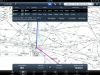
Put in your departure and destination airports and an altitude. At the bottom of the nav log, tap the "ATC Routes" button. You'll see the recently-issued routes just like on fltplan.com and if you tap one it'll become the active flight plan.

I know that FF, for example, allows me to enter a route than include SIDs, STARs, Victor airways, etc. What kind of "automatic" route-finding are you talking about?

I am looking for the auto-route feature like one sees at Voyager or Golden Eagle. It where one can select low altitude VOR to VOR or airway routing and it figures it out on its own. Then I can go in and edit if I want.

Mark, if you use DUATs or the packages that derive from DUATs such as Scott has mentioned, you can put in a departure and destination and then ask it to generate routes using one of the following:

* Victor airway auto-routing
* Victor airway w/SIDs/STARs
* Jet airway auto-routing
* VOR-Direct auto-routing (doesn't care if there's an airway as long as the route remains within the service volume of the VORs used)
* Direct routing for GPS with intermediate lat/longs
* Direct routing for GPS without intermediate fixes
* Direct routing for VOR/DME RNAV (this is VERY nice if you have a KNS 80 aboard)
* User selected routing that can combine all of the above - For example, if I typed KMSN *G KELSI *V KLOM it would route me GPS direct from KMSN to KELSI and via Victor airways from KELSI to KLOM if I remember correctly. (Been a while since I used it.)

In reality, I've never been given an airway routing except on the East coast, with one exception. West of the PA/OH state line, we pretty much get direct all the time except for when Chicago interferes, in which case we get sent to KELSI just about every time (I have gotten RV RFD V128 SMARS Direct... Once).

Scott, one hint that may help you: I'm assuming most of your need for the planning stuff is that you're flying out of the Chicago area and are given specific routes to get out - What you can do is put the beginnings of those routes in - The parts that get you out of Chicago Approach's airspace - And save them as favorites. Then you'll be able to just tap one and put your destination and altitude on the end of it, assuming you're cleared direct after you're out of their airspace.
 
It won't calculate actual winds aloft to give to ATC in a PIREP, for example, but it is continuously updating ETA's, etc. in the nav log based on your GPS groundspeed, and that's the important thing, right?
It is not important if the information I am looking for is the winds aloft. :rolleyes:

You're pretty funny.

I tell you I would like a feature to do A. You respond by saying that feature B serves me in a better way that meets my needs in every way except actually giving me the information I want and I should be happy to get that!

:D:D

When you graduate with your BSEE if you want a job with a telecom equipment vendor you will fit right in with their technical marketing and application teams!!! :D:D
 
Last edited:
Man, you guys like baggin' on ForeFlight don't you? ;)
Everyone has said it is a very good program and is offering suggestions to make it better from their perspective. That is not "baggin' on ForeFlight" and I think you are being unfair to people who are trying to make constructive suggestions and take these suggestions far too personal.

You really sound as though you are responding in a defensive manner. Just because you might not agree with those suggestions does not mean that they should be so quickly dismissed, it is rather disrespectful and if you were an employee or official rep of that company would make them sound very non responsive to customer needs or inputs.
 
It is not important if the information I am looking for is the winds aloft. :rolleyes:

You're pretty funny.


Going from memory since most of the features of WingX are now locked down to me becasue my introductory period is over, but it has an E6B screen. Not sure if calculations are populated with data elsewhere in the program or are exported likewise.

I also remember that WingX has a couple of different spots that allow you to manually "calibrate" the GPS-provided data for various purposes, such as altitude. Not sure about TAS.

Someone with an active subscription might check.
 
Mark, if you use DUATs or the packages that derive from DUATs such as Scott has mentioned, you can put in a departure and destination and then ask it to generate routes using one of the following:
I've generally found the DUAT ifr functionality in that area to be virtually useless. Not the "ATC routes" feature in FltPlan and other sites and in FF, that bases the recommendation on real clearances, is much more useful.
 
Everyone has said it is a very good program and is offering suggestions to make it better from their perspective. That is not "baggin' on ForeFlight" and I think you are being unfair to people who are trying to make constructive suggestions and take these suggestions far too personal.

Please note the winkie ;) ;) ;) It was a JOKE. That is all.

You really sound as though you are responding in a defensive manner. Just because you might not agree with those suggestions does not mean that they should be so quickly dismissed, it is rather disrespectful and if you were an employee or official rep of that company would make them sound very non responsive to customer needs or inputs.

As with many of my posts, I am simply offering an alternative viewpoint. I play "devil's advocate" way too easily I guess... Believe me, I love features as much as the next guy. (I think WingX's split-screen thing is pretty cool, for example.) However, I'm no longer the drooling look-what-this-gadget-does teenager that would go to extra efforts to use the gadgets. I've grown to truly appreciate that a fast, stable application or device is better than a bursting-at-the-seams box of features.

Maybe it's a difference in expectations as well. I bought an iPad and ForeFlight with the expectation that it could replace the reams of paper in my cockpit. IE, I bought it to be an EFB. It long ago vastly exceeded my expectations in that realm, and has grown to the point where it has a lot of the functionality of a handheld GPS.

Therein lies the problem - Because the line between EFB and GPS has been blurred, everyone wants the iPad/ForeFlight combo to be BOTH an EFB *and* a GPS, *right now*. Frankly, I don't think the hardware can support that quite yet, and attempting to make that happen *right now* will lead to a poor user experience, which in my mind would make it go back to BEFORE square one. If the things I originally purchased the device and software for don't work as well as they did on day one because they're being crushed under a mountain of "features" that slow things down, then progress has not been made.

Only when the hardware is there to support that mountain of features, and the designers of the software devise a good UI to allow their users easy access to those features, should the features be added.
 
Please note the winkie ;) ;) ;) It was a JOKE. That is all.
Ok it was not all that clear to me. You know how tone is on a web board. I know you and I know your passion for things.


Maybe it's a difference in expectations as well. I bought an iPad and ForeFlight with the expectation that it could replace the reams of paper in my cockpit. IE, I bought it to be an EFB. It long ago vastly exceeded my expectations in that realm, and has grown to the point where it has a lot of the functionality of a handheld GPS.

Therein lies the problem - Because the line between EFB and GPS has been blurred, everyone wants the iPad/ForeFlight combo to be BOTH an EFB *and* a GPS, *right now*.
I understand.

I want it to be an EFB and Flight Planner more than just an EFB/GPS. But ya gotta admit it is a kick ass EFB/GPS!?!

There are so few things that it is not doing well that I think that speaks volumes. It appears that everyone is trying to play catch up with it. So to stay ahead they may have to add more functionality. The real challenge is can they do that and not screw up what works.
 
I've generally found the DUAT ifr functionality in that area to be virtually useless. Not the "ATC routes" feature in FltPlan and other sites and in FF, that bases the recommendation on real clearances, is much more useful.

Agreed, mostly.

The most useful thing I ever did with the DUATS flight planner was the VOR/DME RNAV routing for a trip I flew in an Arrow with a KNS 80. Not having to pull the plotter out and measure from each VOR was nice, and the route was certainly more accurate as done with DUATS instead of said plotter - DUATS actually figures slant-range distance on those routes, and has a much higher resolution than a plotter on a chart.

Now, I have noticed that I often will input airport pairs that have no previously cleared routes (or maybe they were just cleared direct?), but when going places, especially on the east coast, they tend to stick you on airways so if you file an airway routing you're probably more likely to get "cleared as filed" rather than have to punch a whole bunch of stuff in. So, airway auto-routing would be nice for some people.
 
Ok it was not all that clear to me. You know how tone is on a web board. I know you and I know your passion for things.

You should also know that I'm a pretty good-natured guy and like to joke around a lot... And I've been communicating online long enough to know that tone is often lost, so I use a lot of smilies in an attempt to make it more obvious.

I want it to be an EFB and Flight Planner more than just an EFB/GPS. But ya gotta admit it is a kick ass EFB/GPS!?!

Yes, it is... I love it! (You may have noticed :rofl) It does everything I wanted it to do when I bought it and MUCH more. I'm a very happy customer.

There are so few things that it is not doing well that I think that speaks volumes. It appears that everyone is trying to play catch up with it. So to stay ahead they may have to add more functionality. The real challenge is can they do that and not screw up what works.

Bingo! The usability and stability is what really makes ForeFlight, not the features (despite there being plenty of those, too). They are constantly adding new functionality, but they do so in a measured fashion and I know that there's a lot of internal debate that gets things mostly right before the beta team gets it, and we then try to get any remaining usability issues ironed out. The result, IMNSHO, is a pretty darn good product.

The features will come... But not until they can be done well. That's extremely important.
 
Hmm. Do you show an ETE on your flight log, do you show leg times in your flight log?
You can capture a screenshot by pressing your top button and home button simultaneously. The photo will be saved in "Photos" on the iPad. You Can then embed the photo in a post using tapatalk or you can download it to your computer and attach it as usual.

Thanks for the screenshot/sharing tip.

Here are my sss. (Screenshots)

One shows the flight plan with dep, rte, dest, tas.
The other is the map view with no ete in the hud but yes leg times in the log.
Is that the best we can expect or am I overlooking something?

Much appreciated.
 

Attachments

  • FP.PNG
    FP.PNG
    139.1 KB · Views: 10
  • Map.PNG
    Map.PNG
    773.3 KB · Views: 10
Thanks for the screenshot/sharing tip.

Here are my sss. (Screenshots)

One shows the flight plan with dep, rte, dest, tas.
The other is the map view with no ete in the hud but yes leg times in the log.
Is that the best we can expect or am I overlooking something?

Much appreciated.

There is an ETE on the hud. It's just to the left of the "ATC Routes" button.

Also, you should use "32000ft" instead of "32000" and "350kt" instead of "350". I bet that would solve your problems.
 
Thanks for the screenshot/sharing tip.

Here are my sss. (Screenshots)

One shows the flight plan with dep, rte, dest, tas.
The other is the map view with no ete in the hud but yes leg times in the log.
Is that the best we can expect or am I overlooking something?

Much appreciated.

There is an ETE on the hud. It's just to the left of the "ATC Routes" button. Right under the green dot next to "KSAF".
 
Last edited:
Thanks for the screenshot/sharing tip.

Here are my sss. (Screenshots)

One shows the flight plan with dep, rte, dest, tas.
The other is the map view with no ete in the hud but yes leg times in the log.
Is that the best we can expect or am I overlooking something?

Much appreciated.

Dave,

Try something for me - Enter your entire route, altitude, and airspeed in the text box at the upper right of the Maps tab, and then hit the File & Brief button at the bottom of the nav log (NOT the one at the bottom of the screen).

Does it have your ETE correct now?

It *should* "round-trip" the data properly between the File & Brief tab and the Maps tab, but this is not how it originally worked, so there may be something missing.
 
There is an ETE on the hud. It's just to the left of the "ATC Routes" button. Right under the green dot next to "KSAF".

Jason,

The "kt" and "ft" aren't necessary, ForeFlight can figure out the difference... Well, at least as long as you're not in an SR-71. ;)
 
Thanks for the screenshot/sharing tip.

Here are my sss. (Screenshots)

One shows the flight plan with dep, rte, dest, tas.
The other is the map view with no ete in the hud but yes leg times in the log.
Is that the best we can expect or am I overlooking something?

Much appreciated.
In your log the column labeled has three pieces of information in it.

The leg distance, the leg est. fuel required and the leg ete

For example on your leg from KMRF to ELP the distance is 145NM using 51.7 gal of fuel with an ETE of 0Hours 26 Minutes

Your total ETE is shown at the bottom of the flight log and is 1h06m

If you want ETE in the HUD all you need to do is press a finger on any of the four fields, hold it for a couple of seconds and then select what you want to show there. Then you could select ETE NEXT which would show your ETE to the next waypoint.
 
There is an ETE on the hud. It's just to the left of the "ATC Routes" button.

OK I think one of us has the terms wrong (I suspect me)....I thought the hud was the bottom display and the one at the top was the "flight log".
Correction inbound I trust.

Also, you should use "32000ft" instead of "32000" and "350kt" instead of "350". I bet that would solve your problems.
It will not accept any letters in those boxes.
The altitude is a rolling dial thingy anyway.

Thanks!
 
Did you rubber band or touch plan the route or did you enter it in the text field? I just put your identical flight plan in my iPhone and got a "time enroute' on the flight plan page of 1 hour 6 minutes :mad2: Why isn't it showing up in yours?
 
OK I think one of us has the terms wrong (I suspect me)....I thought the hud was the bottom display and the one at the top was the "flight log".
Correction inbound I trust.

Actually Dave, you are correct.

It will not accept any letters in those boxes.
The altitude is a rolling dial thingy anyway.

There is some confusion because some people are talking about entering altitude and airspeed in the text box on the Maps page. Dave, you seem to be talking about initially entering everything on the File & Brief page, right?

See my previous post in this thread.
 
Dave,
Try something for me - Enter your entire route, altitude, and airspeed in the text box at the upper right of the Maps tab, and then hit the File & Brief button at the bottom of the nav log (NOT the one at the bottom of the screen).
Does it have your ETE correct now?

I left the text of entire route, altitude, and airspeed in the text box as you can see it on my screenshot three posts earlier....and hit the F&B button as requested and this did result in a good entry for ete in the flight plan. Good fix. I will have to try to remember that.

The bar at the bottom of the maps page is still showing ----- for ete dest and ete nxt but that is OK, as the GS is zero.

Muy bueno, gracias.
 
In your log the column labeled has three pieces of information in it.
The leg distance, the leg est. fuel required and the leg ete
For example on your leg from KMRF to ELP the distance is 145NM using 51.7 gal of fuel with an ETE of 0Hours 26 Minutes
Your total ETE is shown at the bottom of the flight log and is 1h06m
...and that is all working good.

If you want ETE in the HUD all you need to do is press a finger on any of the four fields, hold it for a couple of seconds and then select what you want to show there. Then you could select ETE NEXT which would show your ETE to the next waypoint.
As on the screenshot above I have ete dest and ete next displayed already....of course the values are blanked (-----) because the device is stationary.
Tks.
 
It will not accept any letters in those boxes.
The altitude is a rolling dial thingy anyway.

Thanks!


AHA! :idea:

You are inputting your flight plan on the "file and brief" screen first! Whether it is a bug, or simply a feature that doesn't exist, the time enroute field will not automitically update when you enter your data there.

If you were to plan your flight on the maps screen instead, either by touch and select, or by filling it in the text field at the top, and then choose to file from there, the "time enroute" in your flight plan will automatically calculate and populate. IMO it is much easier to do that first, then fill in the blanks such as souls on board and contact info right before you file.

(And yes the ETE in your HUD won't display unless you have a groundspeed but it should show above in the flight log.)
 
Last edited:
Did you rubber band or touch plan the route or did you enter it in the text field? I just put your identical flight plan in my iPhone and got a "time enroute' on the flight plan page of 1 hour 6 minutes :mad2: Why isn't it showing up in yours?

Because nothing I own, or ever will own every works properly. Or, for very long.
:rofl:

To answer your 1st Q,....I entered the data all on the FP page....I didn't know you could enter it on the Maps page.
However, Kent found a fix (click file and brief on the Maps page after making entries on the FP page) PS clicking F&B on the FP page did not help...the ete remained 0:00
 
Dave, you seem to be talking about initially entering everything on the File & Brief page, right?

Precisement, Kent.
I did not know you could make entries on the Maps page. I always start with a flightplan.
 
Because nothing I own, or ever will own every works properly. Or, for very long.
:rofl:

To answer your 1st Q,....I entered the data all on the FP page....I didn't know you could enter it on the Maps page.
However, Kent found a fix (click file and brief on the Maps page after making entries on the FP page) PS clicking F&B on the FP page did not help...the ete remained 0:00

See my post above yours. I think that is the "problem." Most of us find that initially entering a flight plan the way you are doing it is a bit slower than doing the planning from the maps page and then clicking file and brief and filling in the rest of the flight plan fields like SOB and fuel onboard.
 
Thanks AF, I enjoyed the Aha as much as you.
Carry on.
Once again the strength of POA fixes wrongs all over the world.
 
Jason,

The "kt" and "ft" aren't necessary, ForeFlight can figure out the difference... Well, at least as long as you're not in an SR-71. ;)

Yeah. I tried it and figured that out. (which is why your response appears completely out of context :) )
 
Last edited:
I'm not sure I understand what you mean.

I know that FF, for example, allows me to enter a route than include SIDs, STARs, Victor airways, etc. What kind of "automatic" route-finding are you talking about?

He's talking about what some systems already do. You don't enter that stuff, it finds it for you.

You enter departure and destination airport, and hit "VOR to VOR Autoroute" or "Airway AutoRoute" or "Direct" and the appropriate waypoints are added in-between.

A subset of "Direct" I've seen one that does "RNAV Autoroute" that'll give you a great-circle route with a VOR frequency and crossing radial from two VORs every 50 miles or so on the navlog it prints (another thing Foreflight is missing..

If I can print the charts for a backup, why can't I print the navlog?

Or maybe just e-mail it to me like the filed flightplan and the weather and I'll print it from there... ;)

A nice PDF would be great. ;)

For the aborted trip to OSH I had to double-enter the flight plan both in FF and AOPA's online planner to get a nice navlog printout for scribbling on with crayons in the cockpit.
 
Hmm. Do you show an ETE on your flight log, do you show leg times in your flight log?

4004e76d-cc60-ac76.jpg


You can capture a screenshot by pressing your top button and home button simultaneously. The photo will be saved in "Photos" on the iPad. You Can then embed the photo in a post using tapatalk or you can download it to your computer and attach it as usual.

One more way. Go into Photos and email the photo to yourself. Saves having to go find the sync cable.

I hate syncing. iCloud makes me happy, soon. ;)
 
Thanks for the explanation Kent. So, I request that Apple make it possible for such things to occur when your iPad is on WiFi and connected to a power source... as mine often is when it's sitting in my office charging at home. ;-)

If battery life and concern about downloading too much stuff over a limited 3G plan is truly the reason why they limit such functionality, it would be a relatively simple thing (from my perspective) for the iOS to waive normal download / multitasking / installing perspective when the device is connected to AC power and a fast WiFi connection.

That's exactly what iCloud is going to do, supposedly, for Apple Apps. WiFi, power source, downloads begin.

I haven't looked to see if they're going to make that information available to other Apps via an OS API so those Apps can trigger their own background events though.

I wish Tapatalk had multiple-quotes. Sigh.
 
I would like it very much if some VOR's and major airports were shown on the Radar map page. It sure would make figuring out what to file to circumnavigate thunderstorms easier. (The county maps, roads, and bodies of water just don't do it for me.

Wells
 
Back
Top