- Joined
- Jul 4, 2006
- Messages
- 5,128
- Location
- Lincoln, Nebraska
- Display Name
Display name:
Jason W (FlyNE)
I would like it very much if some VOR's and major airports were shown on the Radar map page. It sure would make figuring out what to file to circumnavigate thunderstorms easier. (The county maps, roads, and bodies of water just don't do it for me.
Wells
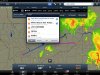
Just hold your finger down where you want to fly and it'll pull up the "nearest" menu with all of the navaids, airports and waypoints to choose from. Or you can hold and drag you course line to where you want to fly and choose from the same options.
")