whereisrandall
Pre-takeoff checklist
- Joined
- Jan 3, 2016
- Messages
- 333
- Location
- Wiscasset, Maine
- Display Name
Display name:
Randall Williams
Hi gang. Please forgive me if this one's been answered before, I couldn't find it elsewhere here.
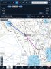
Scenario: I'm in Inverness Florida, headed to Tallahassee. I tell Fore Flight KINF-KTLH, and ask its route advisor what ATC's been giving for clearance between those two points.
The "Airway" option that it gives me is ridiculously routed, but the "ATC Cleared" list gives four really good routes between the two airports. Trick is, they all involve navigating to a DME fix. One of them reads:
KINF-SZW128R/081-KTLH
Take off, and go directly to the 81 DME spot on the 128 radial of the SZW VOR, then KTLH. Easy. Except I don't know how to tell the Garmin to do that. I could stick a user waypoint there, but I can't legally navigate to that user waypoint in IFR. If it were a named fix or intersection, that would be pretty straightforward. But it's not.
An ATP buddy tells me that entering "SZW 128/81" will do it on the FMS in his Embraer, but the GNS 430W not so much.
Anybody know how to do this? I haven't gotten a clearance like this yet, though I know it's coming - just trying to stay ahead of the airplane.
Shiny side up,
Randall


")