TangoWhiskey
Touchdown! Greaser!
Saturday morning armchair flying; playing 'what ifs' with a trip from Alliance Fort Worth (KAFW) to Centennial (KAPA) to see a friend.
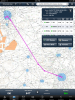
FltPlan.com shows most common routing given to pilots under IFR is "WORTH5.CDS QUAIL.QUAIL6".
A number of questions arise. You can follow this route on SkyVector.com by entering this in the waypoints field, or clicking the link I provided for it: KAFW FERRA SCABI CDS LAA HGO QUAIL KAPA
Other docs:
WORTH5 DP PIC PAGE 1 / WORTH5 DP TEXT PAGE 2
QUAIL6 STAR
Questions:
- From Childress VOR (CDS), which is the terminus of the Worth5 DP, there are no low altitude airways to join Either Lamar (LAA) or Hugo (HGO) VORs on the Quail 6 arrival. If the FltPlan.com "issued clearances" are to be believed as written, is DIRECT TO from CDS to LAA assumed?
- The FltPlan.com arrival is listed as "QUAIL.QUAIL6"; I see QUAIL as an intersection in the arrival, and indeed it is the arrival name, but the transition to be used is not specified, nor is QUAIL a valid transition as best I can tell. Or is it? Are the valid transitions ONLY HGO, LAA, and TODDE, or all of those plus QUAIL, since the procedure is named QUAIL.QUAIL6? If QUAIL is not a valid transition (entry) to the STAR, then I presume the route I'm seeing displayed on FltPlan.com is incomplete and all of these questions are moot.
- In a WAAS GPS equipped plane, can you fly the WORTH5.CDS DP at, say, 8000 or 10000', if cleared by ATC and your filed altitude was that low? Terrain clearance isn't an issue, nor is NAV reception if you're using the GPS for guidance, but the DP shows "FL180" for the segment between SCABI and CDS, and "14000" for the segment inbound to SCABI.