Beech 33A down Minneapolis

I'm sorry to hear this.

My first reaction when I looked at the aviation safety report was that this was a relatively new airplane, then I thought about that, 35 years old is relatively new.

No real point to this other than to make me think how old the fleet is.
 
Judging by the rate of climb following lift-off, his troubles started well before the turn.

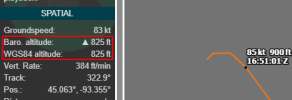
The runway elevation is listed around 860 MSL. The ADS-B altitudes listed must be AGL, which would have had some adequate altitude gained before the left turn. Wonder what the cloud bases were. If entering IMC before the turn, the quick and steep left turn may have initiated a loss of control very soon afterwards.

Had it been the impossible turn back following a complete engine loss, there should have been enough altitude available to lower the nose, descend, turn back and gain some more distance back towards the airport before stalling and crashing. Unless the nose was never lowered much in the first place, and/or a LOC during the turn back.
 
It's not, it reports 29.92 pressure altitude.
It's the length of the ground roll and the rate of climb that makes me wonder.

If it's standard this ADS-B plot (and I'm not arguing it's not MSL) is alway reported in MSL, then this plane was just barely airborne following departing a 3500' long runway, and obviously not accelerating normally.

A normally loaded Bonanza should almost leap into the air. The pilot's failure to recognize the lack of acceleration and an unwillingness to abort the takeoff is hard to comprehend.
 
If it's standard this ADS-B plot (and I'm not arguing it's not MSL) is alway reported in MSL, then this plane was just barely airborne following departing a 3500' long runway, and obviously not accelerating normally.
We know it's reported in MSL for a couple of reasons:
1. It's the way ASD-B out is designed. It uses a combination of barometric and geometric altitude (height above the reference ellipsoid), which is similar. Link to FAA ADSB-FAQ.​
2. Because it says so. ("WGS84 altitude" is the geometric altitude.)​
1777210140596.png​
3. If it were AGL, when we watched the track of an aircraft in straight and level cruise flight, the altitude would constantly change with the elevation of the terrain. In some areas, by thousands of feet. Reports of climb and descent rates would be nonsensical.​

A normally loaded Bonanza should almost leap into the air. The pilot's failure to recognize the lack of acceleration and an unwillingness to abort the takeoff is hard to comprehend.
Definitely agree. There are many of these that are difficult to comprehend until we have more information. We have a long thread where we discussed the ADS-B report, only to learn that it (?) doesn't depict the accident at all. And there have been reliability errors from reports close to the ground in others.
​
 
3. If it were AGL, when we watched the track of an aircraft in straight and level cruise flight, the altitude would constantly change with the elevation of the terrain. In some areas, by thousands of feet. Reports of climb and descent rates would be nonsensical.
Plus, if it was AGL there would have been a near-vertical climb of over 750 feet at liftoff 1000 or so feet from brake release. I don’t think a Bonanza was able to quite make that performance.
 
Last edited:
Plus, if it was AGL there would have been a near-vertical climb of over 750 feet at liftoff 1000 or so feet from brake release. I don’t think a Bonanza was old quite make that performance.
I had a Bo driver tell me he could make that happen
 
The runway elevation is listed around 860 MSL. The ADS-B altitudes listed must be AGL, which would have had some adequate altitude gained before the left turn.
FYI, ADS-B broadcasts two altitudes, one based on GPS and the other based on pressure altitude. The GPS altitude is a value above a model (WGS84) of the surface of the earth and is not corrected for the local gravity (Geoid). The WGS84 value in the vicinity of the airport is -87 feet below the MSL altitude. The pressure altitude is not corrected to MSL and you have to adjust it based on the current altimeter setting. All altitudes have a precision of 25 feet. So converting altitudes to an equivalent MSL altitude is a little involved. What you see is the raw data and not an AGL value or MSL value.
 
Rick A said:
The pilot's failure to recognize the lack of acceleration and an unwillingness to abort the takeoff is hard to comprehend.
Hmmn. Almost no acceleration between 15:40:42 and 16:50:46. And at that point, there was still time to abort. :(
And I have yet to see anything in the Single Engine ACS that even resembles RTO training.

There was one IIRC about 10 years ago, a Mooney at MKC downtown who had a reallly long takeoff run and planted it just across the river..... Found it: https://data.ntsb.gov/Docket?ProjectID=87813
 
Last edited:
Hmm. That doesn't seem to point to anything in particular.
 
Back
Top