A nice little IFR flight KASE-KAPA

denverpilot

Tied Down
Joined
Nov 8, 2009
Messages
55,469
Location
Denver, CO
Display Name

Display name:
DenverPilot
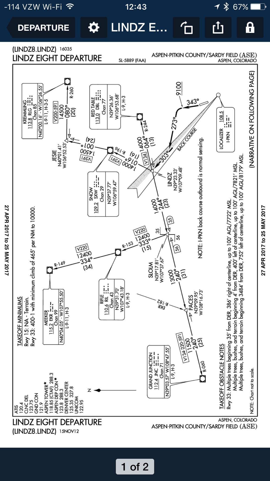
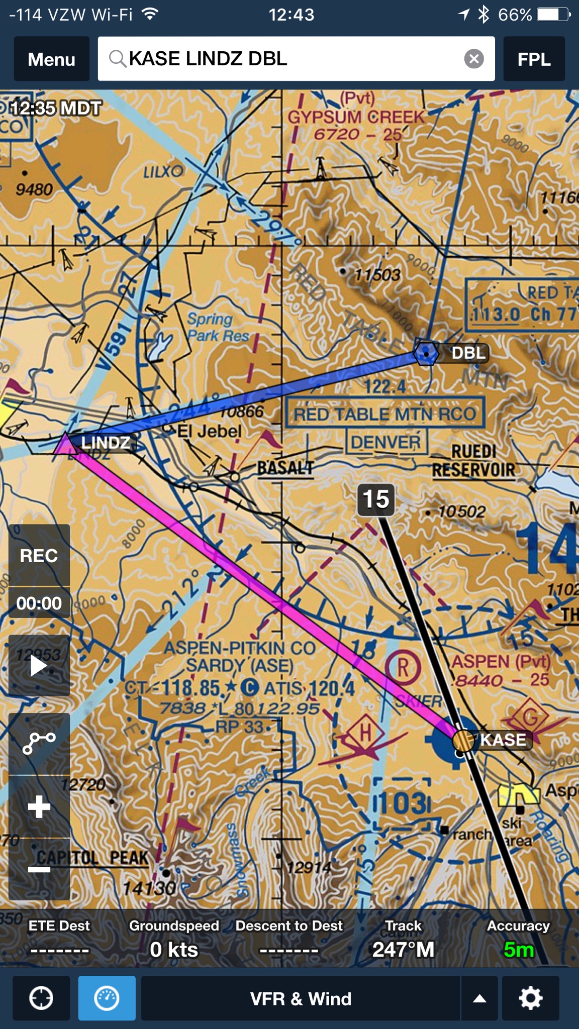
Some of Boldmethod's stuff I have made fun of in the past, but this one is kinda fun. Cirrus IFR flight from KASE-KAPA with flyable and mild IMC in the mountains. And... a dead transponder.


Three nitpicks.

1. During the briefing they said they'd maintain "better than 1000 FPM" to mitigate risks and then right at the beginning of the flight, habit takes over and they pull the power back. (Looks like about 650 FPM after that, and they're still below the terrain a bit, but like I say, it's a nitpick. If that comment was added to "sound smart" in post-production about the ADM, the video should have matched what they said they'd do. Don't bother adding it to the video script if not. Just a video production nitpick. Nothing bad about it.)

2. Really it's kinda silly to stay IFR once they're back to the foothills in VMC weather. Just cancel and go on into APA. Just creating a lot of work for the controllers for no real need. But again, a nitpick and I'm fine with it. I suspect they really wanted to stay IFR knowing they'd turn the footage into a video about how to do IFR without a transponder.

3. At one point he says Aspen can't see Primary radar returns because their radar is "broken". It's not. Aspen is served by a Wide Area Multilateralization system that ONLY sees secondary returns in the valley. It's a series of fixed location receivers on vertical antennas spaced around the valley and a single central transmitter that interrogates transponders and then the system times the return time from the aircraft transponder to each fixed receiver, thus triangulating the aircraft location without expensive rotating or oscillating (or even phased array) radar antenna systems and massive cost to have primary radar installed in that mountainous terrain. I've mentioned it before in discussions about how "NexGen" could have been done much much smarter. So no, KASE's radar is not "broken". They simply do not have Primary radar down in the valley. Maintenance and installation costs would have been astronomical whereas WAM is inexpensive and works great. As long as everyone has a transponder.

Mostly sharing for folks who've never flown out here in the rocks. Check out those fun MEAs! Climb, baby, climb. ;) Looks like it was a lovely day for the flight, too.

Plus @Everskyward might feel a little homesick for KASE if I post this. Hehehe. :)
 
Looks like a beautiful place to fly..Thanks for sharing Nate!
 
What's the difference between wide area multilateration and secondary surveillance radar?
 
What's the difference between wide area multilateration and secondary surveillance radar?

No clue. WAM is a technology, and fairly specific as a name. Secondary surveillance radar probably means something in FAA speak but sounds much more generic to me. One could even call WAM a "secondary surveillance radar" I suppose, but FAA likes names like that to mean something, so I'd have to ask the radar ops guy I know, if it stands for a specific system type.
 
Great video, thanks for sharing!
 
What's the difference between wide area multilateration and secondary surveillance radar?
Secondary is a single site receiving the reply and WAM is multiple sites receiving the reply.
 
I'm a fan of Boldmethod, particularly their quizzes, but I have a different nit on this one and commented on it. When they showed the PFD, I didn't see the localizer displayed on the initial segment of the LINDZ departure. It would have been a good teaching moment about one of the few remaining limitations of GPS substitution, "lateral navigation on LOC-based courses (including LOC back-course guidance) without reference to raw LOC data."
 
I'm a fan of Boldmethod, particularly their quizzes, but I have a different nit on this one and commented on it. When they showed the PFD, I didn't see the localizer displayed on the initial segment of the LINDZ departure. It would have been a good teaching moment about one of the few remaining limitations of GPS substitution, "lateral navigation on LOC-based courses (including LOC back-course guidance) without reference to raw LOC data."
I thought the only limitation was on the final approach segment. Are you saying that the limitation applies to a departure segment as well, if the LOC is used for lateral guidance on it? (What about on a missed approach?) If so, then I just learned something!
 
Yep. Exactly.

@azure, notice that the LOC prohibition is in addition to the general lateral guidance on the FAC prohibition. The language in the AC also appears in the AIM at 1-2-3.c. in Note 2, agains as a note separate form the "lateral guidance" one. You can also see it in the general statements of all the navaids GPS can be used for, VOR, NDB, TACAN, DME. LOC is not there.
 
I couldn't sit through more than about a minute or two of that lecture...
I'm the one who feels a little homesick!
home-sick-smiley.gif
 
Yep, it's pretty explicit. Thanks, I did learn something.
So did I. Ran across that in another Forum where the discussion is do you really need two VHF NAV recievers to fly the good ol' LOC/DME-E into ASE if you have GPS
 
Last edited:
3. At one point he says Aspen can't see Primary radar returns because their radar is "broken". It's not. Aspen is served by a Wide Area Multilateralization system that ONLY sees secondary returns in the valley.

(snip)

So no, KASE's radar is not "broken". They simply do not have Primary radar down in the valley. Maintenance and installation costs would have been astronomical whereas WAM is inexpensive and works great. As long as everyone has a transponder.

In their defense, they probably don't know this, and the ATIS did say "Notice to airmen, Aspen primary radar not available". Sure makes it sound like they have one and it's busted if you don't know better.
 
In their defense, they probably don't know this, and the ATIS did say "Notice to airmen, Aspen primary radar not available". Sure makes it sound like they have one and it's busted if you don't know better.

Yeah, but... he's making an instructional videos so accuracy counts. "Not available" doesn't mean "broken". ;)
 
What I want to know is how they did the video with the G1000 superimposed on the outside video? That's pretty sweet.
 
I might be feeling a little homesick soon, but probably not for Aspen...

I purposely avoided that place, and not because the airport can be squirrely either.
 
I purposely avoided that place, and not because the airport can be squirrely either.
I don't have any problem with Aspen as a place, or even as an airport. It just seemed that we often had to go there when everyone else was there. The last day of a holiday weekend, ugh...
 
@denverpilot I found another nitpick.

IMO, they should not have accepted direct Red Table. That's technically an off-route clearance, and the OROCA in that area is 16,300. They were about 3000 feet below that.

Was it safe? Yeah, probably, in that they weren't going to hit anything. They were about 1-1.2 miles from LINDZ at that point and thus within the bounds of V134 and within 2000 feet of the MEA there (MEA has to be at least 2000 AGL in mountainous terrain, right?).

However, ATC didn't actually know exactly where they were at that point and thus MVAs wouldn't be taken into account. I'm surprised they got that clearance in the first place... Unless there was a position report that they cut out of the video.

On the part of both pilots and ATC, they were using a "normal" procedure in an abnormal situation.
 
I'm a fan of Boldmethod, particularly their quizzes, but I have a different nit on this one and commented on it. When they showed the PFD, I didn't see the localizer displayed on the initial segment of the LINDZ departure. It would have been a good teaching moment about one of the few remaining limitations of GPS substitution, "lateral navigation on LOC-based courses (including LOC back-course guidance) without reference to raw LOC data."

That's quite interesting.

It means I've been doing intermediate segments on ILS's wrong. Everyone knows that the CDI has to be on VLOC after the FAF, but the implication is that it must also be on VLOC when intercepting the final approach course, even if that's far ahead of the FAF or GS interception. Some examples where that would be relevant are KNUQ ILS OR LOC/DME RWY 32R, and KOAK ILS OR LOC/DME RWY 28R, both of which have several stepdown fixes on the final approach course prior to the FAF.

I'll head up and correct that ASAP.

It also means the automatic G1000 CDI switching behavior is wrong.
 
@denverpilot I found another nitpick.

IMO, they should not have accepted direct Red Table. That's technically an off-route clearance, and the OROCA in that area is 16,300. They were about 3000 feet below that.

Was it safe? Yeah, probably, in that they weren't going to hit anything. They were about 1-1.2 miles from LINDZ at that point and thus within the bounds of V134 and within 2000 feet of the MEA there (MEA has to be at least 2000 AGL in mountainous terrain, right?).

However, ATC didn't actually know exactly where they were at that point and thus MVAs wouldn't be taken into account. I'm surprised they got that clearance in the first place... Unless there was a position report that they cut out of the video.

On the part of both pilots and ATC, they were using a "normal" procedure in an abnormal situation.

Interesting catch! The terrain is such a PITA up there for IFR ops.

Assuming position reporting that got cut out, can ATC then still vector you at their MVA (which may be lower than what the pilot's information shows for a minimum safe altitude) when on an off route clearance with no radar?

I assume they can, but that's more in their rules than ours. I'd have to go look that one up. And I don't have any (even old leaked internet ones) MVA charts for the ASE area. Not sure what the MVA is in the valley there, but you won't hit anything (but only barely clear the ridge that DBL sits on, and not by much) at 12,000. If you aren't at 12,000 before making a right turn, you'd better be questioning the turn. Of course that's why LINDZ to DBL is 14,000.

Any ATC folk want to weigh in? Controller doing the right thing there? Can they vector direct Red Table in that scenario prior to LINDZ with or without position reporting, sans radar?

(And I'll throw out there that what they showed being done there is really common in that area. "Direct Red Table" is probably words @Everskyward heard a LOT going into or out of ASE...)

I know WHY they do it. They want you out of the way for opposite direction inbounds who are going to head to LINDZ and land the other way. One way airports are a PITA for IFR ops, too. LOL. The video even alludes to it since there's an inbound holding over DBL.

For those playing along... the departure and what the VFR/terrain chart looks like for that departure below. The departure essentially takes you "down valley" just like you would VFR leaving there, toward Carbondale, and then turns you toward the ridgeline where DBL sits on top of it after you've (in theory) climbed to 14,000. That's one of the hardest parts about that departure in anything that's not turbocharged, you can't maintain the climb rate necessary to make 14,000 by LINDZ. Ironically, the LINDZ to DBL portion of that departure takes you right over the highest little molehill before you reach the ridgeline, though.

Kent's right about be thing for sure up there. Think twice before accepting anything "direct" off of a published route in the rocks!

5515e79fc3f2ea89edb72538394f198e.png


0299caf9c7e1157d79b65a6dd4c73d76.png
 
That's one of the hardest parts about that departure in anything that's not turbocharged, you can't maintain the climb rate necessary to make 14,000 by LINDZ. 299caf9c7e1157d79b65a6dd4c73d76.png[/IMG]

Curiosity killed the cat so I had to go run the rough numbers... at 90 knots groundspeed in the climb you need to be able to do 600 f/min from takeoff all the way to 14,000, to make that all work out. 15 miles to climb 6000'.

Clark's airplane can play. Mine usually can't. Or I become a 65-70 knot "speed bump" in everyone's way, slogging along trying to make the climb gradient. Ha.

Turbos is mo' betta up there, for sure.
 
He gave an altitude report prior to being given the direct to DBL. The altitude was 13,000 so a right turn towards DBL was okay from a terrain clearance point of view. He was over 2,000 feet above the highest terrain along his route.
 
Curiosity killed the cat so I had to go run the rough numbers... at 90 knots groundspeed in the climb you need to be able to do 600 f/min from takeoff all the way to 14,000, to make that all work out. 15 miles to climb 6000'.

Clark's airplane can play. Mine usually can't. Or I become a 65-70 knot "speed bump" in everyone's way, slogging along trying to make the climb gradient. Ha.

Clark's airplane might be able to do it on a cold day or with about 10 knots of headwind. The likely outcome is hitting oil temperature limits before 14,000. I've wanted to bolt an aux oil cooler on the turbo oil return line for quite awhile now. Finding airflow and not screwing up total engine cooling airflow is a bit of a problem...
 
Assuming position reporting that got cut out, can ATC then still vector you at their MVA (which may be lower than what the pilot's information shows for a minimum safe altitude) when on an off route clearance with no radar?

I've heard of radar vectoring, but I've never heard of non-radar vectoring! :rofl:
 
I've heard of radar vectoring, but I've never heard of non-radar vectoring! :rofl:

There's probably a different term for it, but I assume off-airway routings were always possible in a non-radar environment. The system was built to handle it, as evidenced by every controller thinking everyone is /G these days. Ha. Cleared direct 1000 miles away... if anything airways are the thing that's being lost over time.

But in terrain, there's usually a reason for the blue line over the magenta line... ;)
From AIM 5-3-4:

Unpublished RNAV routes are direct routes, based on area navigation capability, between waypoints defined in terms of latitude/longitude coordinates, degree−distance fixes, or offsets from established routes/airways at a specified distance and direction. Radar monitoring by ATC is required on all unpublished RNAV routes, except for GNSS− equipped aircraft cleared via filed published waypoints recallable from the aircraft’s navigation database.​
 
@denverpilot I found another nitpick.

IMO, they
@denverpilot I found another nitpick.

IMO, they should not have accepted direct Red Table. That's technically an off-route clearance, and the OROCA in that area is 16,300. They were about 3000 feet below that.

Was it safe? Yeah, probably, in that they weren't going to hit anything. They were about 1-1.2 miles from LINDZ at that point and thus within the bounds of V134 and within 2000 feet of the MEA there (MEA has to be at least 2000 AGL in mountainous terrain, right?).

However, ATC didn't actually know exactly where they were at that point and thus MVAs wouldn't be taken into account. I'm surprised they got that clearance in the first place... Unless there was a position report that they cut out of the video.

On the part of both pilots and ATC, they were using a "normal" procedure in an abnormal situation.
The OROCA being 16,300 doesn't make it wrong. OROCA's are not a "hard" altitude restriction. They make it easier to comply with 91.177 than figuring out exactly where you are and staying 1000/2000 above, within 4 miles of course. The Catch 22 of OROCA's is, if you don't know exactly where you are, then how do you know you're within the "grid"
 
There's probably a different term for it, but I assume off-airway routings were always possible in a non-radar environment. The system was built to handle it, as evidenced by every controller thinking everyone is /G these days. Ha. Cleared direct 1000 miles away... if anything airways are the thing that's being lost over time.

But in terrain, there's usually a reason for the blue line over the magenta line... ;)
They were. Getting direct routes to VOR's and other NAVAID's was used. Service volume had to be complied with so the 1000 mile thing wasn't happening. Then along comes GPS. Now direct to fixes as well as NAVAID's is cool. Then GPS becomes the norm, and yeah, the slant alpha and uniform riff raff gets a direct every now and then
 
Why is everyone talking about unpublished RNAV routes and /G in this context? Red Table is a VOR. We all know how to home a VOR without GPS, right?
 
Why is everyone talking about unpublished RNAV routes and /G in this context? Red Table is a VOR. We all know how to home a VOR without GPS, right?

Yes, the question we're discussing is more about whether it was appropriate for them to accept the clearance direct to the VOR at the altitude where they were, regardless of whether it was a VOR, intersection, or GPS fix.
 
Interesting catch! The terrain is such a PITA up there for IFR ops.

Assuming position reporting that got cut out, can ATC then still vector you at their MVA (which may be lower than what the pilot's information shows for a minimum safe altitude) when on an off route clearance with no radar?

I assume they can, but that's more in their rules than ours. I'd have to go look that one up. And I don't have any (even old leaked internet ones) MVA charts for the ASE area. Not sure what the MVA is in the valley there, but you won't hit anything (but only barely clear the ridge that DBL sits on, and not by much) at 12,000. If you aren't at 12,000 before making a right turn, you'd better be questioning the turn. Of course that's why LINDZ to DBL is 14,000.

Any ATC folk want to weigh in? Controller doing the right thing there? Can they vector direct Red Table in that scenario prior to LINDZ with or without position reporting, sans radar?

(And I'll throw out there that what they showed being done there is really common in that area. "Direct Red Table" is probably words @Everskyward heard a LOT going into or out of ASE...)

I know WHY they do it. They want you out of the way for opposite direction inbounds who are going to head to LINDZ and land the other way. One way airports are a PITA for IFR ops, too. LOL. The video even alludes to it since there's an inbound holding over DBL.

For those playing along... the departure and what the VFR/terrain chart looks like for that departure below. The departure essentially takes you "down valley" just like you would VFR leaving there, toward Carbondale, and then turns you toward the ridgeline where DBL sits on top of it after you've (in theory) climbed to 14,000. That's one of the hardest parts about that departure in anything that's not turbocharged, you can't maintain the climb rate necessary to make 14,000 by LINDZ. Ironically, the LINDZ to DBL portion of that departure takes you right over the highest little molehill before you reach the ridgeline, though.

Kent's right about be thing for sure up there. Think twice before accepting anything "direct" off of a published route in the rocks!

5515e79fc3f2ea89edb72538394f198e.png


0299caf9c7e1157d79b65a6dd4c73d76.png
Vector would be the wrong term here because he wasn't in radar contact, but giving Direct DBL was probably fine. They didn't have his "exact" position, but they did know he was established on the LINDZ8 and not to LINDZE yet. From a point anywhere along the LINDZ8, direct to DBL is likely contained within a MVA "sector" that could be as low as about 12,900. They got a report from him out of 13,400 then gave him direct. It passes the logic check with me.
 
Last edited:
Vector would be the wrong here because he wasn't in radar contact, but giving Direct DBL was probably fine. They didn't have his "exact" position, but they did know he was established on the LINDZ8 and not to LINDZE yet. From a point anywhere along the LINDZ8 direct to DBL is likely contained within a MVA "sector" that could be as low as about 12,900. They got a report from him out of 13,400 then gave him direct. It passes the logic check with me.

Makes sense. I wish MVA charts were published.
 
I couldn't sit through more than about a minute or two of that lecture...
I never can.

I like their quizzes, though. Even if they repeat them way too often. :) And I am sure I am not the only one who offered help to review quizzes before they publish them but they declined so we will still see some funny errors or bad wording in the quizzes. Oh well, that's Internet for ya. :)
 
Back
Top