N175PT
Pre-Flight
- Joined
- Jul 4, 2013
- Messages
- 30
- Display Name
Display name:
Tim
You should see a map with or without a GPS signal, internal or external. At least I do. I don't believe you have a good database loaded. Also see if you can select IFR low instead of the VFR sectional, if so then yeah database issue. You may also verify you have a current subscription. This is exactly what happend to me when I let it expire after the free trial period while I tried FF.
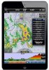
Now back to WX with Skradar.
Tim
Now back to WX with Skradar.
Tim