Who's got the biggest...

COFlyBoy

Line Up and Wait
Joined
Nov 23, 2009
Messages
904
Location
Aurora, CO
Display Name

Display name:
COFlyBoy
antenna?

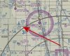
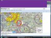
There's huge antenna about 30 miles east of Denver International Airport (KDEN). Its 1995 feet tall.

picture.php


Anyone got a bigger one? :nono:
 
In talking size does girth matter? Or how about how it is used?
 
Last edited:
Dang I was close.

Just west of OLU (Columbus NE) is a tower that's 1973 ft
 
KVLY-TV Tower, North Dakota...2063ft. :D
 

Attachments

  • KVLY-TV.jpg
    KVLY-TV.jpg
    93.3 KB · Views: 27
Last edited:
We only have small antennas in Idaho. But they are on top of 10,000' mountains.
 
The USN array at Cutler Maine. It's about 30 towers strung together. Have to talk to those subs, and the wavelength is VERY very long.
 
The USN array at Cutler Maine. It's about 30 towers strung together. Have to talk to those subs, and the wavelength is VERY very long.

Watch out for the wires strung from mountain top to mountain top across the valley at NCS Jim Creek in Washington state. Same idea as your array in Maine.
 
The Clayton Antenna(s) SE of RDU will get you attention!
 

Attachments

  • clayton antenna.jpg
    clayton antenna.jpg
    187.2 KB · Views: 51
Now the question is, do a/c hit them?
This site lists... I think I count 9 collisions. I suspect it is not a complete listing. (we had one here and its not listed) It is interesting to read of other things that bring them down.
 
Last edited:
There's a gaggle TV towers east of Springfield, MO (KSGF) that reach up to 2000' AGL, 3600' MSL. I believe one or two planes have been ensnared over the years whilst scud running.
 
Last edited:
Now the question is, do a/c hit them?
This site lists... I think I count 9 collisions. I suspect it is not a complete listing. (we had one here and its not listed) It is interesting to read of other things that bring them down.

It's not usually the towers that are hit, it's the cables that hold them up that people forget about.
 
The towers northwest of KOMA aren't particularly tall, but they sure are in the way for an extended right base to 14R.

KVLY has the biggest in the U.S. ... http://en.wikipedia.org/wiki/KVLY-TV_mast

The Wikipedia article is linked because it also includes this gem...

"Its height above mean sea level is 3,038 ft (926 m). Some time after its completion, the Federal Communications Commission (FCC) and Federal Aviation Authority (FAA) imposed a policy that states, "Although there is no absolute height limit for antenna towers, both agencies have established a rebuttable presumption against structures over 2,000 feet above ground level."[5] The FCC and FAA may approve a taller structure in "exceptional cases.""
 
The one near rhinelander, wi is 3326' msl but only 1682' agl. I'll be flying close to it on my way up to eagle river this Saturday. I start getting nervous anytime a structure is above me when flying.
 
The one near rhinelander, wi is 3326' msl but only 1682' agl. I'll be flying close to it on my way up to eagle river this Saturday. I start getting nervous anytime a structure is above me when flying.

If you're going to Eagle River, you might as well hop on over to 6Y9 and say hi to my parents.
 
If you're going to Eagle River, you might as well hop on over to 6Y9 and say hi to my parents.

I just might. Figured I'd try Leifs cafe for breakfast, then some wandering on the way back to FLD.
 
The one near rhinelander, wi is 3326' msl but only 1682' agl. I'll be flying close to it on my way up to eagle river this Saturday. I start getting nervous anytime a structure is above me when flying.

I think it's kind cool to see them floating past your wingtip (as long as the visibility is good). There is a whole gaggle of towers on the edge of lake Erie a bit south of here.
 
I flew past a bunch of tall towers in North Carolina one time. Someone told me they were US Navy sub-communication towers. They were very tall. Anyone know how tall? West of Kill Devil Hill, as I remember.

Dan
 
Oh, and I forgot about the 650' TV tower that's ON THE AIRPORT PROPERTY at Springfield Downtown (3DW) and the three or four other 350' (+/-) towers that are in the traffic pattern.

That airport can be quite interesting for someone who is not familiar.
 
Well I know you all are dying to find the highest obstruction in your state. Well, here is a list by state generated from the FAA obstruction data file, complete with links to Skyvector so you can check it out on the charts:

State City AGL MSL Link
AK PORT CLARENCETOWER 1350 1357 http://skyvector.com/?ll=65.24455,-166.88667
AL WINDHAM SPRINGSTOWER 2000 2640 http://skyvector.com/?ll=33.48,-87.43056
AL KELLERMANTOWER 2000 2675 http://skyvector.com/?ll=33.48083,-87.40083
AR REDFIELDTOWER 2000 2272 http://skyvector.com/?ll=34.47333,-92.20306
AZ WICKENBERGTOWER 1820 4470 http://skyvector.com/?ll=33.88722,-112.98028
CA WALNUT GROVETOWER 2049 2049 http://skyvector.com/?ll=38.24,-121.50194
CO BYERSTOWER 1995 6945 http://skyvector.com/?ll=39.92278,-103.97222
CT FARMINGTONTOWER 1339 2049 http://skyvector.com/?ll=41.70361,-72.83167
DC WASHINGTONTOWER 761 1049 http://skyvector.com/?ll=38.96278,-77.02639
DE SHARPTOWNTOWER 1002 1048 http://skyvector.com/?ll=38.50472,-75.64333
FL MILLER CROSSRDSTOWER 1890 2025 http://skyvector.com/?ll=30.91989,-85.74148
GA METCALFTOWER 2000 2222 http://skyvector.com/?ll=30.67056,-83.94056
HI WAIANAETOWER 1500 1564 http://skyvector.com/?ll=21.41992,-158.14822
IA ALLEMANTOWER 2000 2988 http://skyvector.com/?ll=41.80917,-93.615
IA ALLEMANTOWER 2000 2970 http://skyvector.com/?ll=41.80972,-93.62139
IA JAMESTOWER 2000 3369 http://skyvector.com/?ll=42.58667,-96.23278
ID AVERYCATENARY 1077 3327 http://skyvector.com/?ll=47.26833,-115.93944
IL CHICAGOBLDG 2000 2589 http://skyvector.com/?ll=41.88987,-87.61489
IN TRAFALGARTOWER 1133 2002 http://skyvector.com/?ll=39.4075,-86.14778
KS HUTCHINSONTOWER 1501 3048 http://skyvector.com/?ll=38.06056,-97.76389
KY LA GRANGETOWER 1739 2549 http://skyvector.com/?ll=38.45639,-85.42444
LA VACHERIETOWER 1999 2003 http://skyvector.com/?ll=29.95278,-90.72417
MA WORCESTERTOWER 1350 2049 http://skyvector.com/?ll=42.33583,-71.71528
MD BALTIMORETOWER 1280 1549 http://skyvector.com/?ll=39.33622,-76.64941
ME CORNISHTOWER 1667 2549 http://skyvector.com/?ll=43.84562,-70.76132
MI ATLANTATOWER 1349 2409 http://skyvector.com/?ll=45.13806,-84.16222
MN BIG LAKETOWER 1509 2454 http://skyvector.com/?ll=45.38322,-93.70858
MO FORDLANDTOWER 2000 3547 http://skyvector.com/?ll=37.17389,-92.94083
MO SYRACUSETOWER 2000 2872 http://skyvector.com/?ll=38.62667,-92.86778
MS INVERNESSTOWER 2000 2115 http://skyvector.com/?ll=33.37278,-90.54056
MT EAST HELENASTACK 850 4823 http://skyvector.com/?ll=46.57389,-111.9225
NC WHITE LAKETOWER 2000 2055 http://skyvector.com/?ll=34.57806,-78.44167
NC DALLASTOWER 2000 2720 http://skyvector.com/?ll=35.36417,-81.18667
NC CLAYTONTOWER 2000 2328 http://skyvector.com/?ll=35.67639,-78.53556
ND FARGOTOWER 2063 3058 http://skyvector.com/?ll=47.34219,-97.28916
NE GENOATOWER 1973 3729 http://skyvector.com/?ll=41.54111,-97.67944
NH HAMPTON FALLSTOWER 722 735 http://skyvector.com/?ll=42.90806,-70.85111
NJ TUCKERTONTOWER 1000 1035 http://skyvector.com/?ll=39.63139,-74.35278
NM WHITE SANDSCATENARY 1898 7618 http://skyvector.com/?ll=33.61667,-106.38528
NV JACKASS FLATSTOWER 1520 5160 http://skyvector.com/?ll=36.78,-116.2425
NY MANHATTANBLDG 1892 1906 http://skyvector.com/?ll=40.71299,-74.01313
OH MANSFIELDTOWER 1576 2916 http://skyvector.com/?ll=40.55583,-82.44472
OK ALFALFATOWER 2000 3500 http://skyvector.com/?ll=35.25106,-98.61494
OR PORTLANDRIG 1500 1575 http://skyvector.com/?ll=45.52028,-122.6825
PA PHILADELPHIATOWER 1277 1519 http://skyvector.com/?ll=40.0425,-75.24222
RI TIVERTONTOWER 1001 1049 http://skyvector.com/?ll=41.59694,-71.18917
SC AWENDAWTOWER 2000 2016 http://skyvector.com/?ll=32.92472,-79.69917
SD ROWENATOWER 1999 3426 http://skyvector.com/?ll=43.505,-96.55639
TN BLAINETOWER 1751 3049 http://skyvector.com/?ll=36.135,-83.72472
TX COLLINSVILLETOWER 2008 2726 http://skyvector.com/?ll=33.53721,-96.83176
UT MAGNASTACK 1207 5540 http://skyvector.com/?ll=40.72167,-112.19778
VA SUFFOLKTOWER 1259 1282 http://skyvector.com/?ll=36.80883,-76.50314
VT BURLINGTONTOWER 445 545 http://skyvector.com/?ll=44.49611,-73.21306
WA SPOKANETOWER 940 4548 http://skyvector.com/?ll=47.59472,-117.29917
WI FAIRCHILDTOWER 1998 3095 http://skyvector.com/?ll=44.66389,-90.96139
WV SCOTT DEPOTTOWER 1576 2549 http://skyvector.com/?ll=38.42093,-81.92402
WY GILLETTETOWER 1153 5830 http://skyvector.com/?ll=43.99917,-105.25472
 
Last edited:
2000' sure seems to be the magic height limitation (though some seem to have cheated a touch by setting the tower in a concrete base or some such)
 
What is the limit on guyed towers? (what is the physical entity that prevents taller?)
Seems like the highest is 2000' but function may be what is topping them out there.
 
In talking size does girth matter? Or how about how it is used?

Affirmative.

Well then, we have several cell phone towers with a lot of girth, and a bunch of microwave towers that are very big, and interesting.

I need a cigarette for some odd reason, and I don't even smoke....yet. :wink2:
 
I love those tree towers. We have a number of them out here that don't turn white with snow in the winter like the rest of the forest they're "hidden" in. :rofl:
 
On my long XC for my private I passed over Minnesota's tallest tower...Big Lake at 1500ft. It made a darn good checkpoint because you could see from at least 10 miles away.
 
Definitely not the tallest, but maybe the biggest? Camp Hero, Montauk Point, NY has a defunct ATC radar from the 1960s. When decommissioned, the local fisherman lobbied to have the antenna left in place because it was a far more visible landmark than Montauk Point light. I saw it in operation a few times and from a distance it faded to almost not visible (90* aspect) to just huge (0* or 180* aspect.

From the website:

At the end of a tree-lined, rock-strewn trail that opens onto a wide asphalt road is a locked gate, a sign that reads “Area Closed: Trespassers Will Be Prosecuted,” and the park’s most startling military fossil: a weary-looking AN/FPS-35 radar system, deployed in 1960 and operational until 1980. From a distance the tower is a dark monolith in the forest, topped with a 70-ton, 120-foot-wide antenna that looks like a magnified fly’s wing. Up close, it is more sad than sinister. Its windows are covered. Its air vents are silent.

-Skip
 

Attachments

  • camp-hero-nyt.jpg
    camp-hero-nyt.jpg
    44.9 KB · Views: 21
Oh, and I forgot about the 650' TV tower that's ON THE AIRPORT PROPERTY at Springfield Downtown (3DW) and the three or four other 350' (+/-) towers that are in the traffic pattern.

That airport can be quite interesting for someone who is not familiar.


That just so happens to be the site of my worst mistake flying. Scud running. I was very lucky to have missed that tower. I saw it out my right window.
 
There's a gaggle TV towers east of Springfield, MO (KSGF) that reach up to 2000' AGL, 3600' MSL. I believe one or two planes have been ensnared over the years whilst scud running.

SGF App. has been good to remind folks of them thar pointy-up sticks around Fordland.
 
Back
Top