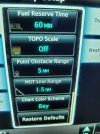
Hot on the heels of the missing ILS glideslope (was a bad splitter), I see another issue on this new 750. There's no altitude range arc. In the map settings, the option to turn the altitude range arc isn't even there. I see where it is supposed to be. Very odd. Any thoughts? I have not tried resetting to default map settings but I don't know why that would resurrect a missing map option button. See photo attached. The option should be under the "Chart Color Screen" option and before the "Restore Defaults" option.
You are using an out of date browser. It may not display this or other websites correctly.
You should upgrade or use an alternative browser.
You should upgrade or use an alternative browser.
Where's my GTN750xi altitude range arc?
- Thread starter DWillens
- Start date
Ryan Klems
Line Up and Wait
Do you mean the glide range ring, or the "Boeing banana" ... time expected to reach selected altitude little blue arc? From your other post I know you have G5's so you should be able to get this display. For the glide range ring, it's possible they didn't configure the glide ratio and best glide speed in the configuration. For the banana, I don't recall there being any sort of configuration setting for that. As long as you have some sort of display capable of feeding airdata and selected altitude to the unit (you have dual G5's), and everything is set up, I believe that should "just work". From your prior posts on the lack of GS, I see you have ARINC 429 IN 1 set to EFIS FORMAT 2, which should be correct (assuming the gad29's corresponding output is set to EFIS/AIRDATA 1 SDI 1), and should provide all the info needed to enable this feature. Are you setting the desired altitude on the G5? If you go the Winds/Density Altitude calculator in utilities on the GTN are you seeing pressure altitude/baro altitude and such filled in from the sensor data?
Hi Ryan:
No Boeing Banana. Glide range ring works fine. VNAV works fine. Altitude set in G5 altitude bug. I'll check the utilities page next time. I'm 99% sure baro data is being sent. I know temp data is being sent because I see density altitude on the ground in the G5.
I've used this function in other airplanes and I agree it always seemed to "just work."
bnt83
Final Approach
What is altitude range arc?
I've never seen it or heard of it. The GTN Xi Pilot's Guide Jan 2023, has one page that references it. Doesn't say how to turn it on or off

I've never seen it or heard of it. The GTN Xi Pilot's Guide Jan 2023, has one page that references it. Doesn't say how to turn it on or off
Last edited:
If you look at the photo in my original post, the option to turn it on or off should be the last item before "restore defaults." You can also see it referenced in the diagram of the "map settings" tree in the manual. If you have the Garmin trainer, you can also see it where it belongs in the map settings page.
I don't have it.
I don't have it.
bnt83
Final Approach
Makes me wonder if the trainer software is way ahead of the actual unit software. I've had an Xi since they came out as well as a bunch of G5s including one airplane with the GFC500, I updated all the software in all of them to latest Rev in March and I've never seen this option.If you look at the photo in my original post, the option to turn it on or off should be the last item before "restore defaults." You can also see it referenced in the diagram of the "map settings" tree in the manual. If you have the Garmin trainer, you can also see it where it belongs in the map settings page.
I don't have it.
Its been interesting to see how things have been added and deleted via software updates over the years. Our Xis, G5s, and GFC were installed within a few months of the STCs being released and I've updated the softwares at annual inspection time fairly consistently.
All this is good info. Makes me think it's not my installation. I have honestly seen this work in Slings with G650s and GFC, but those planes have G3x's and it shows on the G3x not the 650. I wonder if that function only currently works where there is a separate display, not the 750 itself. But it seems odd that the 750 display itself couldn't show this if it has the right data.
I wouldn't even have noticed this if I hadn't literally on my first flight been given instructions for a crossing restriction that wasn't part of the flight plan and I didn't feel like trying to figure out how to create an along track waypoint for a new waypoint. Granted it wouldn't have been that difficult.
I wouldn't even have noticed this if I hadn't literally on my first flight been given instructions for a crossing restriction that wasn't part of the flight plan and I didn't feel like trying to figure out how to create an along track waypoint for a new waypoint. Granted it wouldn't have been that difficult.