Where is it you live?

Lawreston

En-Route
Gone West
Joined
Feb 23, 2005
Messages
4,573
Location
Georgetown, ME
Display Name
Harley Reich
Home Airfield
KIWI
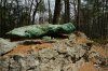
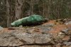
is what people may say to me. So I just say, "Get on Route 127 to Reid State Park, go six miles. Watch out for the big turtle, then drive ½ mile. My access road is on the left."

:o)
 

Attachments

  • Turtle_1.jpg
    Turtle_1.jpg
    544.7 KB · Views: 26
  • Turtle_2.jpg
    Turtle_2.jpg
    683.7 KB · Views: 58
  • Turtle_3.jpg
    Turtle_3.jpg
    610 KB · Views: 33
Just a possum-trot south of the Great Dismal Swamp, between the peanut mills and about a million acres of cotton.
 
Before they paved the road out to the airport, the directions went:

Take I70 east to the Watkins exit
Turn north, drive as far as you can
Turn right, drive 1 mile
Turn left, drive as far as you can on paved road
Turn right, drive as far as you can on paved road
Turn left, drive as far as you can on paved road.

Welcome to the airport!
 
is what people may say to me. So I just say, "Get on Route 127 to Reid State Park, go six miles. Watch out for the big turtle, then drive ½ mile. My access road is on the left."

:o)

I'm liking "under the downwind, abeam the approach end of one seven" ;)
 
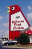
Anyone in the Atlanta area that lives in Marietta references everything to the "Big Chicken"
 

Attachments

  • atlantabigchicken.jpg
    atlantabigchicken.jpg
    53.6 KB · Views: 19
Get off the highway. Go south to the next light. Turn left. I am where the speed limit changes from 55 to 35.
 
On a diagonal line extending from the Pepsi plant to the corner deli.
 
Near the big building with the bug-zapper on top, across from where the Clement St. Cafe used to be.
-harry
 
Anyone in the Atlanta area that lives in Marietta references everything to the "Big Chicken"
I love that sign. When me and SO where looking at houses to buy in that area we knew we wanted to be able to use that 'big chicken' in our direction to the house.
 
When I lived in Rapid City... it was.. down main street, past the dinosor, turn left....
 
Stay on 21 until you see the McDonald's, turn on Chestnut then make a left at the stop sign, and it's the big brick building on the right with the smokestack.
 
Go past the silo, take the 2nd right, then make your first three rights, and it's the house with the flag on the front (on the right).
 
Underneath the left downwind for runway 17.
 
Anyone in the Atlanta area that lives in Marietta references everything to the "Big Chicken"
When we moved to Atlanta the Big Chicken had been taken down so that long needed repairs could be made. People would give us directions of "turn right where the Big Chicken used to be", which wasn't much help to us having no idea what they were talking about.
 
Along the shore of the southernmost extent of Puget Sound. On a street mislabeled by Google maps and most other on-line mapping sites.
 
Back
Top