VFR over a broken layer

The other issue is that your destination weather can change enroute leaving you no options. If you are in instrument training and can shoot an ILS in actual that would help in case you need to declare an emergency bc you can't get down, but you really don't want it to get to that point. If you get stuck on top don't be afraid to call ATC and ask for the closest VFR airports, if there aren't any in range don't be afraid to declare an emergency and have them help guide you to the ground.
 
I'm curious about something. Let's say you take off in marginal VFR and this marginal VFR contains a broken layer around 2,000 feet. You find a hole and get above and are in crystal clear skies. Your destination is also clear below 12,000. You are able to maintain contact with the ground but technically you are above the ceiling while traveling above the broken layer. Are you still legal?

Yup. You don't need to maintain contact with the ground. 1000 above, 500 below, 2000 laterally. Thats VFR. Smart? that's up to you. If something prevents you from staying up there, like for instance your engine decides to take the rest of the day off, you'll have a little more than the usual adventure getting down. Don't forget to stay VFR while climbing up through the hole, make sure it's big enough.
 
Maybe I missed it if someone stated it earlier, but IIRC, a broken layer is considered a ceiling, so hole or no hole, VFR you can't go through it. Scattered, no problem.

It could be an issue if it is below 1000 feet. Other than that it is not. If you can do the 1000/500/3 thing while climbing up through, you're good to go.
 
It could be an issue if it is below 1000 feet. Other than that it is not. If you can do the 1000/500/3 thing while climbing up through, you're good to go.

And 2000 lateral - that's a 4000-ft hole (three quarters of a mile) around the plane, all the way through. So, if you're circling to climb ... ;-)
 
And 2000 lateral - that's a 4000-ft hole (three quarters of a mile) around the plane, all the way through. So, if you're circling to climb ... ;-)

oops. forgot to put that one in and it's the most important in this situation. good catch
 
I've flown over the top VFR more times than I can count. These days we have incredible wx reporting, so you can update your destination as you form your strategic plan. Going down to Atlanta I was at 9500 feet, cool, smooth and doing 130 knots (in a Cherokee!). Hit tall clouds in northern Georgia, had to drop down to a thousand feet to scud run. Now its hot and bumpy and I'm doing 90 knots. Which do you think I prefer?

Yeah, its possible I could encounter an emergency while on top. If so, I'll have to keep the shiny side up for the two minutes I descend through the clouds. In the conditions during which I usually do this its VFR under the clouds, just unpleasant. I get below and my options are the exact same as they would have been had I been scud running. Actually, they're better, since during the descent from altitude I would have pointed the nose at something landable and made some on-the-edge of frantic calls to ATC.

But in this day and age no one should be surprised at the wx at their destination unless its changing rapidly.
 
Bring your laser range finder to measure - make sure it's 2,000', and not 1,999' . . .

Seriously, you aren't at risk for a violation, since nobody on the planet knows the size of the hole except you, and you only have a rough guess. If it's big enough, and you climb through without issue, you done good. Otherwise, you did not do good.
 
I've flown over the top VFR more times than I can count. These days we have incredible wx reporting, so you can update your destination as you form your strategic plan. Going down to Atlanta I was at 9500 feet, cool, smooth and doing 130 knots (in a Cherokee!). Hit tall clouds in northern Georgia, had to drop down to a thousand feet to scud run. Now its hot and bumpy and I'm doing 90 knots. Which do you think I prefer?

Yeah, its possible I could encounter an emergency while on top. If so, I'll have to keep the shiny side up for the two minutes I descend through the clouds. In the conditions during which I usually do this its VFR under the clouds, just unpleasant. I get below and my options are the exact same as they would have been had I been scud running. Actually, they're better, since during the descent from altitude I would have pointed the nose at something landable and made some on-the-edge of frantic calls to ATC.

But in this day and age no one should be surprised at the wx at their destination unless its changing rapidly.

I challenge the assertion that your options are the same or better.

If you'd been scud running, you'd have the lay of the land and know you're pointed towards your best option.

Popping out, you'll need some time to familiarize yourself - especially if you find your previously-committed-to "landable" spot to be less than hospitable.

I'm not saying your options are worse (letting down thru the clouds). Just saying you don't know and won't until you get there.
 
So long as Steingar agrees that the destination weather is known and fairly stable I agree with him. I'd prefer to be above than to scud run. Get up and over and fly till the tanks run dry.

I wouldn't race weather to a destination above or below.
 
I challenge the assertion that your options are the same or better.

If you'd been scud running, you'd have the lay of the land and know you're pointed towards your best option.

Popping out, you'll need some time to familiarize yourself - especially if you find your previously-committed-to "landable" spot to be less than hospitable.

I'm not saying your options are worse (letting down thru the clouds). Just saying you don't know and won't until you get there.

If you're below you have far less time to reach an airport or call for help. It is a good point that during your descent you won't have a look at the ground, but if you've a chart you should have a decent idea of what you're descending into. It is true that once you break out you'll have to make some quick decisions. But you're far likelier to find an airport coming down from 10K feet than from 2.
 
I don't know the answer but:

If you're above and have a reason for immediate landing you can declare or request SVFR to get DOWN.

If you're scud running, can you request SVFR or declare to get UP?
 
If my obstacle database is up to date and visibility is decent, scudding is o.k. but man I sure don't like it. Unless it's completely CAVU and I'm just doing it for fun.

We have some towers here and there that go up to 2000' AGL.

Many of us don't have eyes like an eagle anymore....
 
The primary risk in these situations is that if you have some sort of issue which requires an unplanned/emergency landing prior to reaching clear skies - you can't see where you're going. Even with an instrument rating this is tricky - but at least you know how to shoot an approach if you still have power. Or if you don't have power, at least you can keep the plane upright.

I'd say the bases of the clouds are a bigger factor in that decision. If you are going to break out at 1500-2000' AGL then you have very little time to pick a landing spot or identify an airport. Not to mention obstacle and terrain clearance.
 
The OP is a situation that is legal but that I have never tried (and I mean VFR over a widespread area of clouds). My concern has always been around engine failure. Sure, that's an emergency I'm no longer worried about legality but more about safety. I'll do what I have to do to descend, but do I have enough altitude between the bottom of the deck and the top of the dirt to do anything useful? Having a moving map here would help a lot.

So I'm thinking... yes I might do it if I were high enough above the layer to glide beyond it to an airport or if the layer is high enough AGL to allow maneuvering upon breaking out (and do I really want to be in clouds, VFR, maneuvering to land, with an engine out? Nope!).

Next thought is if I'm VFR above even a scattered layer, will those scattered puffies build into me or are they a truly stable layer? Will the heating of the day make them become unstable and build up to my altitude? Or fill in?

That was always the mental contortion I did when I was VFR and still to some degree as IFR... and then I'd nearly always either go under them or not go at all. Call me a (|) if you will :D
 
Next thought is if I'm VFR above even a scattered layer, will those scattered puffies build into me or are they a truly stable layer? Will the heating of the day make them become unstable and build up to my altitude? Or fill in?

This. I'm not trying to persuade anyone else to get their instrument rating, but I've been in this exact situation, and I hate diving back down in to the heat, haze and turbulence just so I don't get stuck on top of something I cant -stay- on top of.

I've read some of the pros on here even say that they're usually in IMC at the begining and end of a trip, and that enroute they try to stay VMC. That. I want to be able to do that.
 
I don't know the answer but:

If you're above and have a reason for immediate landing you can declare or request SVFR to get DOWN.

If you're scud running, can you request SVFR or declare to get UP?

SVFR is only available within the surface area of Class B, C, D, and E airports....not somewhere enroute. That's why the tower controller says "The field is IFR; what are your intentions?" Then, when you say "I would like a VFR clearance," you get a clearance just like an instrument pilot. Be ready to copy.

His/her authority ends at the dashed lines on the sectional.

Bob Gardner
 
Airspace formerly known as a control zone.
 
This guy was flying over the marine layer at night in Marin county. Unfortunately, things did not end well for him.
 
This guy was flying over the marine layer at night in Marin county. Unfortunately, things did not end well for him.

Being over the marine layer was the least of his problems.

Being a dumb **** was the cause of his accident. He crashed with an "engine failure" consisting of one empty tank and one full one, and descended all the way from 6000 feet without realizing it.
 
Just one more point for the "hanger talk."...

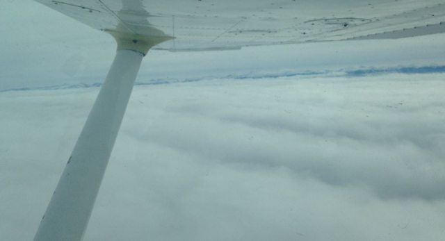
It is certainly smoother 'VFR Over the Top' and I did it a lot but be aware that weather can change. Flying from Kentucky to a private field west of Chicago, preflight WX planning said we'd be in broken or scattered at arrival.

Nope!!! The weather had changed and it was full OVC. I had flight following so popped in and, explaining my situation, asked if there was a VFR field nearby.

Controller: "Stand by one..."

Another controller came on: "Are you instrument rated?"

Me: "Rated, no -- qualified, yes."

He gave perfect vectors though the deck and setting me up for a nice northbound final at my destination.

HOWEVER... the descent and ground speed looked very wrong until I saw the windsock on top of the clubhouse.

"Never fly into the sock!!!" The wind was now from the south.

Up and back to set up the approach the other way.

Lessons:
1) the weather changed, with the overcast coming in early.
2) with the forecast weather changed, ask yourself,
"Could the surface winds have changed, too?"

I learned from the experience. Hope others can, too. :)
 
Being over the marine layer was the least of his problems.

Being a dumb **** was the cause of his accident. He crashed with an "engine failure" consisting of one empty tank and one full one, and descended all the way from 6000 feet without realizing it.

Was that released? There was conjecture but I don't see a probable yet.

Still, I'm guessing he would have liked to have had visual contact with the ground...not that it would have helped all the much out there.
 
Was that released? There was conjecture but I don't see a probable yet.

Still, I'm guessing he would have liked to have had visual contact with the ground...not that it would have helped all the much out there.

No, it was not released.

I've seen wreckage photos, and one tank is obviously torn open along a seam and the other isn't. I've also seen a transcript that is fully consistent with intermittently getting "unusable" fuel during maneuvers.

Not official, but I don't think I've ever seen an NTSB report go into that kind of detail.

What has been released is that he did have a post-crash fire. So, he clearly wasn't completely out of fuel.
 
I appreciate the skew-t advice as I totally learned from this thread. I'm just curious why we don't have an accurate system for knowing cloud tops aside from pilot reports. It seems crazy to me that in today's day and age we can't know for certain how high a cloud goes. As far as I can tell these skew t's are still, at best predictions. Call me crazy but when I call 1800wxbrief they give me predictions for tops too and on the day that was the catalyst for my original question the predictions were for tops to 15,000 and they were not above 3,000. I'm asking for technology that may not exist and I get that but can we agree that it should?

You do understand that clouds can change dramatically in a matter of minutes. What kind of technology are you proposing? the instrument ticket solves it, (provided you really become adept at using it.) other wise , a flight in " the sandwich" might end up in a disaster. Also important to remember that all briefs are not equal. I've been given some that were totally inaccurate an hour later.
 
You do understand that clouds can change dramatically in a matter of minutes. What kind of technology are you proposing? the instrument ticket solves it, (provided you really become adept at using it.) other wise , a flight in " the sandwich" might end up in a disaster. Also important to remember that all briefs are not equal. I've been given some that were totally inaccurate an hour later.
^This. My one and only VFR-into-IMC event came after a briefing that said I'd have good weather for the flight, things were forecast to improve. There were little low puffies around even as I launched, and not only did things NOT improve, by the time I reached my destination they had gone to VERY marginal VFR ceilings. And I had a feeling the forecast might go sour, just based on years of living around the Lakes. If I'd had the sense God gave a tomato, I'd have scrubbed that day.
 
I've flown over the top VFR more times than I can count. These days we have incredible wx reporting, so you can update your destination as you form your strategic plan. Going down to Atlanta I was at 9500 feet, cool, smooth and doing 130 knots (in a Cherokee!). Hit tall clouds in northern Georgia, had to drop down to a thousand feet to scud run. Now its hot and bumpy and I'm doing 90 knots. Which do you think I prefer?
I don't know what kind of weather reporting you're referring to, Michael, but METARs on my XM setup are only updated once every hour, if that, even from stations that update every few minutes on ForeFlight and SkyVector. Unless you're within range to receive the AWOS direct, I doubt you're going to be able to do better than that. Time was when you could reliably get updates via Flight Watch (122.0), but last I heard FW was being phased out and I haven't even tried to contact them in a few years. If the weather situation is changing rapidly, absent pireps from aircraft coming towards you from your destination, I'm not sure I would count on being able to get info that's current enough to really be reliable. Trends, probably yes, so strategic thinking if you're going to do this is an absolute must.

I actually agree with the rest of your post. I don't think you're too much worse off as a VFR-only pilot in case of an emergency with low ceilings than you would be with an IR, provided you declare without delay, follow ATC instructions faithfully, and are able to stay in control during the descent through IMC. Being in a position to successfully shoot an approach without power would be dumb luck in a lot of places. I'd want a vector straight to the nearest airport and hope I can make it with enough altitude to line up with a runway and land.

Note that flight watch is not being phased out, only the distinct 122.0 frequency. The service is being taken over by the other Lockmart employees, and I understand that it will now be available 24x7, not just the limited hours that 122.0 is available. never mind that the generally published frequencies will now be used for in-flight briefings too, resulting in potential congestion.
 
Took off CAVU, landed CAVU, but encountered this over Wyoming. Lasted about 20 minutes. But if the fan had quit, there was no place to go but down. Not optimal.

264ABtWl.jpg
 
Took off CAVU, landed CAVU, but encountered this over Wyoming. Lasted about 20 minutes. But if the fan had quit, there was no place to go but down. Not optimal.

That's also true if you're IFR above a layer.
 
Bring your laser range finder to measure - make sure it's 2,000', and not 1,999' . . .

Seriously, you aren't at risk for a violation, since nobody on the planet knows the size of the hole except you, and you only have a rough guess. If it's big enough, and you climb through without issue, you done good. Otherwise, you did not do good.

You're right that you can't measure it exactly and the feds ain't up there measuring it either. But you have to ask yourself why that 2000 foot restriction is there. It's there so that you and another aircraft who is operating IFR in those clouds have time to see and avoid each other when he pops out of the cloud. Unless somehow you KNOW, and you probably don't, that there are no IFR aircraft in the area then don't get to close to those clouds.
 
You're right that you can't measure it exactly and the feds ain't up there measuring it either. But you have to ask yourself why that 2000 foot restriction is there. It's there so that you and another aircraft who is operating IFR in those clouds have time to see and avoid each other when he pops out of the cloud. Unless somehow you KNOW, and you probably don't, that there are no IFR aircraft in the area then don't get to close to those clouds.

If you're VFR on FF, talking to the controllers and the IFR aircraft is talking to the same controllers wouldn't that concern be mitigated somewhat? Isn't that basically how IFR pilots avoid collisions in instrument conditions?

Although I suppose we might assume the VFR pilot in this scenario might not want to be talking to ATC... at least with his real tail number.
 
You do understand that clouds can change dramatically in a matter of minutes. What kind of technology are you proposing? the instrument ticket solves it, (provided you really become adept at using it.) other wise , a flight in " the sandwich" might end up in a disaster. Also important to remember that all briefs are not equal. I've been given some that were totally inaccurate an hour later.

Very good point. I'm not talking about trying to climb above a towering cumulus cloud. I'm talking about a layer of clouds. We all know the types of clouds being described, the ones that are just there and not ones containing moisture( well more than what it takes to generate a cloud in the first place.)

When I get to a computer( responding on my phone) I'll share some pictures from the day in question so everyone has a sense of the types of clouds I'm thinking of. I'll tell you though that I have 2 pictures taken a few seconds apart. One shows out the right side of the plane( broken layer) the other shows out the left( very high layer with nothing resembling a cloud down low for as far as you can see.) That hole was where I went to to get down below.
 
Last edited:
I don't know what kind of weather reporting you're referring to, Michael, but METARs on my XM setup are only updated once every hour, if that, even from stations that update every few minutes on ForeFlight and SkyVector. Unless you're within range to receive the AWOS direct, I doubt you're going to be able to do better than that. Time was when you could reliably get updates via Flight Watch (122.0), but last I heard FW was being phased out and I haven't even tried to contact them in a few years. If the weather situation is changing rapidly, absent pireps from aircraft coming towards you from your destination, I'm not sure I would count on being able to get info that's current enough to really be reliable. Trends, probably yes, so strategic thinking if you're going to do this is an absolute must.

Of course. We've been able to get wx from Flight Watch since I started in the game, and it only got better with XM. We can now get all this stuff off ADS-B signals. Yes, the report is old but you have it and all its neighbors.

To be honest, I'm not trying to do some sort of fake IFR thing. I mostly go over places that have endemic cloud cover, like the rocks east of us. I can go under and have a bumpy ride, or over for a smooth one. Yeah, if the mill quits its bad news and don't I know it. But I really don't think it any worse being on top than on the bottom. One of the first things a CFI ever told me was "altitude is safety".

I actually agree with the rest of your post. I don't think you're too much worse off as a VFR-only pilot in case of an emergency with low ceilings than you would be with an IR, provided you declare without delay, follow ATC instructions faithfully, and are able to stay in control during the descent through IMC. Being in a position to successfully shoot an approach without power would be dumb luck in a lot of places. I'd want a vector straight to the nearest airport and hope I can make it with enough altitude to line up with a runway and land.

You and me both. Thankfully the new airplane has a nice autopilot too, so if I ever have to keep the shiny side up in a pinch I have a nice tool to help me. To be honest, the biggest problem I've had doing this is I can be easily out climbed by clouds. Its happened more than once, including both legs of my recent sojourn in Georgia.
 
That's also true if you're IFR above a layer.

That's also pretty much true - "no place to go but down" - even when severe clear.

Yes, options are more limited over a broken or overcast layer, but if one is positionally aware, one should still know where the nearest airports are, especially in this age of GPS.
 
………………..

You and me both. Thankfully the new airplane has a nice autopilot too, so if I ever have to keep the shiny side up in a pinch I have a nice tool to help me. To be honest, the biggest problem I've had doing this is I can be easily out climbed by clouds. Its happened more than once, including both legs of my recent sojourn in Georgia.
Many a pilot has come to grief by depending on "George" to do what they didn't have the skill to do themselves.
 
On hazy days, with less than 5 miles vis, it's hard to tell if the broken layer is closing up// I get Claustrophobic... Unless its CAVU and I know my destination is Clear below my altitude... I wouldn't do it... I definitely wouldn't do it if I knew I'd be looking for a hole when I got there... ( I know that's not the OP's scenario) Just say'n...
 
Many a pilot has come to grief by depending on "George" to do what they didn't have the skill to do themselves.

Says you. Sorry, I've flown legal VFR conditions with zero reference to any kind of horizon, i.e. instrument conditions. Kept the shiny side up for way more than the requisite two minutes, too. But I have to admit, I do like George.
 
Note that flight watch is not being phased out, only the distinct 122.0 frequency. The service is being taken over by the other Lockmart employees, and I understand that it will now be available 24x7, not just the limited hours that 122.0 is available. never mind that the generally published frequencies will now be used for in-flight briefings too, resulting in potential congestion.
I stand corrected - must have misremembered what I read, which was quite some time ago. Regardless, if there isn't a dedicated frequency, then as you say, congestion will be a problem. Not only that, but FSS outlets are frequently OTS for extended periods, and finding a frequency that works is very often a process of trial and error. In some areas, it's just not possible to raise them at all.
 
Back
Top