VFR/IFR ceiling requirements

tonynsx

Pre-Flight
Joined
Oct 3, 2019
Messages
42
Display Name

Display name:
tony
Hello, this is my first post here.

I'm working on a Python script that takes in metar data and decides if an airport is VFR/IFR/MVFR etc. This is the website that I'm getting the info from,

https://www.aviationweather.gov/metar/data?ids=kbwi&format=decoded&date=&hours=0.

I'm using this website to decide if an airport is IFR/VFR. I understand the visibility requirements, but not the ceiling. What if an airport is overcast at 500, broken at 5000, scattered at 3000? What takes priority to decide the ceiling requirement?

https://www.aviationweather.gov/metar/help?page=plot
 
Please don't delete my first post, I have links on there, but they're not spam
 
Hello, this is my first post here.

I'm working on a Python script that takes in metar data and decides if an airport is VFR/IFR/MVFR etc. This is the website that I'm getting the info from,

https://www.aviationweather.gov/metar/data?ids=kbwi&format=decoded&date=&hours=0.

I'm using this website to decide if an airport is IFR/VFR. I understand the visibility requirements, but not the ceiling. What if an airport is overcast at 500, broken at 5000, scattered at 3000? What takes priority to decide the ceiling requirement?

https://www.aviationweather.gov/metar/help?page=plot
Ceiling is defined as the lowest overcast Or broken layer. So. In your example, the ceiling is 500 AGL.
 
What if an airport is overcast at 500, broken at 5000, scattered at 3000?

You also won't get a report of OVC with BKN above it. You could have SCT then BKN then OVC in ascending height, but you won't see anything listed after OVC - or at least I've never seen one.
 
Will your script also include LIFR?
 
Will your script also include LIFR?
Mine does. The real pain in the ass is when you get the data from military airfields who format things differently.
 
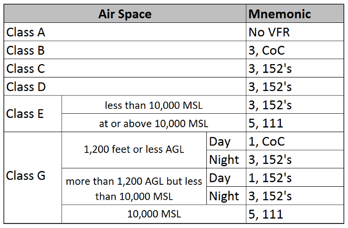
What if the field in in uncontrolled airspace

And what about time of day?

vfr_weather_minimums_2.png
 
Hello, this is my first post here.

I'm working on a Python script that takes in metar data and decides if an airport is VFR/IFR/MVFR etc. This is the website that I'm getting the info from,

https://www.aviationweather.gov/metar/data?ids=kbwi&format=decoded&date=&hours=0.

I'm using this website to decide if an airport is IFR/VFR. I understand the visibility requirements, but not the ceiling. What if an airport is overcast at 500, broken at 5000, scattered at 3000? What takes priority to decide the ceiling requirement?

https://www.aviationweather.gov/metar/help?page=plot

There are several sites available at www.1800wxbrief.com that show the ceiling/visibility status of airports. What will your proposed script add that is not already available?

Bob Gardner
 
Hello, this is my first post here.

I'm working on a Python script that takes in metar data and decides if an airport is VFR/IFR/MVFR etc. This is the website that I'm getting the info from,

https://www.aviationweather.gov/metar/data?ids=kbwi&format=decoded&date=&hours=0.

I'm using this website to decide if an airport is IFR/VFR. I understand the visibility requirements, but not the ceiling. What if an airport is overcast at 500, broken at 5000, scattered at 3000? What takes priority to decide the ceiling requirement?

https://www.aviationweather.gov/metar/help?page=plot

That couldn’t happen. The 500 foot Overcast would prevent the observer from seeing the layers above. You will see Scattered layers beneath Broken and those beneath Overcast, but not the other way around. Broken and Overcast constitute Ceiling. Scattered and Few layers are not ‘Ceilings.’
 
There are several sites available at www.1800wxbrief.com that show the ceiling/visibility status of airports. What will your proposed script add that is not already available?

Bob Gardner

Sucks butt on mobile device.
When I try to access the site on my mobile, it requests login and password. Then I have to go to desktop site. Then I have to go to maps link. Then I have to pinch and zoom and scroll. Then I have to click on the color dot to see what the weather is.

The one I wrote is WAY quicker to grab weather by a state, weather within a certain radius of an airport, weather along a route, or weather of specific stations. And you don't have to create an account. It's not graphic, but I also on purpose didn't want it to be. And you can QUICKLY see whether that MVFR is OVC012 or BKN025. I've already got the info I want before I get the info for the first weather station from leidos.
 
Last edited:
Take a look at Avia Weather, an android app.
 
Used it. Didn't like it. It was actually the impetus to get me to roll my own.
Add MOS forecasts for airports without TAFs and you might have something special.
 
Add MOS forecasts for airports without TAFs and you might have something special.

If the MOS data was easily grabbed and parseable it wouldn't be that difficult. But it's a mess.
 
If the MOS data was easily grabbed and parseable it wouldn't be that difficult. But it's a mess.
Agreed. But not easy is the sign of something really good. I had what you have on my personal home page more than a decade ago by scripting to accessing the data from aviationweather.gov.
 
Agreed. But not easy is the sign of something really good. I had what you have on my personal home page more than a decade ago by scripting to accessing the data from aviationweather.gov.

Theres *probably* a way I could do it. The data is all there, but it's like a Jackson Pollack crossed with chimps at the zoo work.
 
Back
Top