Vertical Navigation

Davidl13

Pre-takeoff checklist
Joined
Dec 2, 2015
Messages
156
Display Name
Papaco
Some thoughts on Vertical Navigation… regardless of if you are hand flying or Auto Pilot , using VS or VNAV ,.. I use a specific strategy that works well.. and it is my experience, ATC uses this as well in their instructions, although it is not specifically stated….

Let’s say you are at 18,000’ and your pattern altitude or your IAF is 3,000’. ATC will tell you to descend to 12,000, then later 10,000 and continue to step you down … pretty typical… one way to do this is to descend at whatever standard rate you are used to, let’s say 500 or 1000 FPM…. That is not how I do it…

What I do is at 18,000 I (in the Gtn 750 or through math) create a straight line descent profile to go from 18,000 to 3,000’ and I fly that path… and 9 out of 10 times, when I am approaching the first step down altitude, ATC will then clear me to the next step down altitude, keeping me on a stable straight line descent to my target, without ever having to step down… ATC recognizes what you are going… and I would argue their steps are designed to do the same

I have flown with many that dive and drive and it creates more work, more changes and it is a less smooth experience…

There you go, my thoughts for the day
 
From the AIM

5-3-3. Additional Reports

a. The following reports should be made to ATC or FSS facilities without a specific ATC request:

1. At all times.

(c) When unable to climb/descend at a rate of a least 500 feet per minute.
 
and then all your best plans go out the window when atc has you up high for too long…or wants you low super far out for traffic. Tribal knowledge and time in the saddle help alot.
 
My experience that they are targeting a 3° descent for light pistons is the same as @MauleSkinner.

But, I don't do what you do. If I am 18,000' and I get an instruction to descend to 12,000' without more, I'm setting up a 500-600 FPM VS descent with a 12,000' target altitude. If I want to use VNAV (as I definitely would if it were given it as a crossing restriction), same thing. Target altitude is my cleared altitude.

One reason is that my experiences have been different than yours. ATC level-offs tend to be traffic/airspace related and I've had level offs far more than lower clearances before I ever got there. The other reason is that I know that the single most common IFR pilot deviation has, with amazing consistency, been an altitude bust for years. There are various reasons, but I don't want to add to that risk by setting up a descent below my clearance and relying on myself to not have a momentary distraction or simply forget that I have to hit the ALT button if I don't get lower before I reach it.
 
I rarely get high enough to require a plan for my descent. I fly for fun, and for the view. Once I get above 5,000' agl, the view loses its interest for me. I have my IFR rating, but vastly prefer flying VFR now so I can wander around the sky and check out things that seem interesting from afar. I'm retired, and use my plane for fun, not as a practical mode of transportation. I had enough of practical decision making during my career. Now I'm all about the smiles/mile. Fortunately, my current plane provides a LOT of those smiles.
Morning-Coffee.jpeg
 
My experience that they are targeting a 3° descent for light pistons is the same as @MauleSkinner.

But, I don't do what you do. If I am 18,000' and I get an instruction to descend to 12,000' without more, I'm setting up a 500-600 FPM VS descent with a 12,000' target altitude. If I want to use VNAV (as I definitely would if it were given it as a crossing restriction), same thing. Target altitude is my cleared altitude.

One reason is that my experiences have been different than yours. ATC level-offs tend to be traffic/airspace related and I've had level offs far more than lower clearances before I ever got there. The other reason is that I know that the single most common IFR pilot deviation has, with amazing consistency, been an altitude bust for years. There are various reasons, but I don't want to add to that risk by setting up a descent below my clearance and relying on myself to not have a momentary distraction or simply forget that I have to hit the ALT button if I don't get lower before I reach it.

Of course you don’t descend below your cleared altitude.. what I am describing is a descent angle, not an altitude
 
Of course you don’t descend below your cleared altitude.. what I am describing is a descent angle, not an altitude

Your OP used a lot of words to say “after entering the altitude constraint in the GTN, you need to configure the VNAV Profile page to the desired/calculated descent angle.

44324a2d4a5e0a86931283ab10c108df.jpg
 
I don’t know what you are saying above, but you have left me with unclarity…

Your altitude constraint is places
D in your altitude preselect.. not the GTN

In the Gtn you put the target alt of your IAF (or your desired FINAL destination altitude (some fix in the terminal environment) … and you create a straight line VS from where you are now (in my example 18,000) to your IAF…

The step down cleared altitudes are place in you altitude preselect so you don’t bust altitudes… my strategy is to create a likely best case scenario. For atraight line VNAV instead of increased workload of diving and driving
 
Of course you don’t descend below your cleared altitude.. what I am describing is a descent angle, not an altitude
I was reading this
What I do is at 18,000 I (in the Gtn 750 or through math) create a straight line descent profile to go from 18,000 to 3,000
What is the selected altitude in your PFD (or autopilot altitude preselect)? If 3000, there’s exactly the problem I described. If 12,000 you’re not creating a descent angle to 3000 and the AP will level off at 12.

If this technique works for you, go for it. I’m just saying I wouldn’t.
Perhaps I don’t understand what you are doing.
 
Your altitude preselect is your PFD.. this is how you fly, this is what your autopilot sees… so if you are cleared to 12,000, you would set the PFD alt preselect to 12,000

Your Gtn has your flight plan… and your IAF is 3000… you are currently at 18,000… you select 3,000 and set a VNAV path from where you are 18,000 to your IAF, 3,000… let’s say for a moment given your distance from you IAF this gives you a 700fpm vertical descent rate. So you descend at 700fpm…

Your ALT pre select is set to 12,000, so you won’t descend past 12,000….

Like I said, 9 out of 10 times, as you approach 12,000, ATC will call you and clear you to the next “step down alt” , so you will dial that into you alt pre select and continue on your perfect glide path down

There is no risk
 
…Your altitude constraint is places
D in your altitude preselect.. not the GTN…
The GTN series will calculate VNAV sans autopilot. V(ertical) S(peed) R(equired) is an option field on the Map and Default Nav page of the GTN.
 
Your altitude preselect is your PFD.. this is how you fly, this is what your autopilot sees… so if you are cleared to 12,000, you would set the PFD alt preselect to 12,000

Your Gtn has your flight plan… and your IAF is 3000… you are currently at 18,000… you select 3,000 and set a VNAV path from where you are 18,000 to your IAF, 3,000… let’s say for a moment given your distance from you IAF this gives you a 700fpm vertical descent rate. So you descend at 700fpm…

Your ALT pre select is set to 12,000, so you won’t descend past 12,000….

Like I said, 9 out of 10 times, as you approach 12,000, ATC will call you and clear you to the next “step down alt” , so you will dial that into you alt pre select and continue on your perfect glide path down

There is no risk
Have at it if you like it.

Edit: I'm still not sure what you are doing. I've been trying to set something like this up in the Garmin trainer, but I can't figure it out. I can set up something like this using VNAV Direct and playing with the vertical numbers, but then the assumption is that I am direct to the IAF. You may be getting that 90 percent of the time, but I'm definitely not.

Can you show an example, displaying both the resulting flight plan and the PFD?
 
Last edited:
On the big picture this the idea…

You an altitude X and your IAF is at Y altitude.

In a perfect scenario, the best possible thing you can do to have a smooth descent and a very low pilot workload is to draw a straight line from where you are now X to where you are going Y … in this case that is a vertical navigation because all we are talking about is the vertical aspect of flight in this conversation ie. Vertical
Navigation… you can turn left or right as your flight plan determines… your vertical path X to Y remains the same. Ie… you have to descend Z amount of feet in Z1 amount of miles.

You can use math to figure this out or use a Gtn navigator…

From math or your Gtn you determine a 700fpm descent rate will put you at your iAF in a perfect straight line desecnet from the moment ATC clears you Lower… they will Likely give you a medium altitude of some sort and step you down… your goal is to begin your descent on that perfect slope from where you are… not some standard rate you arbitrarily determined in flight school like 500fpm or 1000fpm…

Do you understand this concept?

Btw.. call me, I’d be happy to explain
406-404-4957
 
Your OP used a lot of words to say “after entering the altitude constraint in the GTN, you need to configure the VNAV Profile page to the desired/calculated descent angle.

44324a2d4a5e0a86931283ab10c108df.jpg

This is not the correct screen to do what I am saying, you would initiate from the flight plan page itself
 
IMG_1222.jpeg

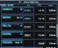
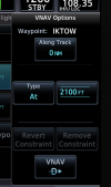
You would press the alt of a specific fix and on the next screen you make choice of AT, Above, between… etc… and then direct v path and save…
 
FWIW most arrivals I fly is a "descend via" using the altitude constraints along the way. The FMS figures the TOD and put the bottom altitude in the ALT Alert. Done. If ATC wants me to just descend and cross XYZ at a certain altitude, put that altitude in the fix and direct to ALT.
 
FWIW most arrivals I fly is a "descend via" using the altitude constraints along the way. The FMS figures the TOD and put the bottom altitude in the ALT Alert. Done. If ATC wants me to just descend and cross XYZ at a certain altitude, put that altitude in the fix and direct to ALT.
I think the OP just discovered VNAV, and assumed no one else had ever heard of it. ;)
 
I think the OP just discovered VNAV, and assumed no one else had ever heard of it. ;)

And gets the same clearances he gets. If I’m VFR and ready for my descent, ATC usually gives me pilot discretion to whatever I requested.

From an IFR perspective, it’s a crapshoot what I’ll get, but that’s the nature of routes and fields I’m flying to.
 
On the big picture this the idea…

You an altitude X and your IAF is at Y altitude.

In a perfect scenario, the best possible thing you can do to have a smooth descent and a very low pilot workload is to draw a straight line from where you are now X to where you are going Y … in this case that is a vertical navigation because all we are talking about is the vertical aspect of flight in this conversation ie. Vertical
Navigation… you can turn left or right as your flight plan determines… your vertical path X to Y remains the same. Ie… you have to descend Z amount of feet in Z1 amount of miles.

You can use math to figure this out or use a Gtn navigator…

From math or your Gtn you determine a 700fpm descent rate will put you at your iAF in a perfect straight line desecnet from the moment ATC clears you Lower… they will Likely give you a medium altitude of some sort and step you down… your goal is to begin your descent on that perfect slope from where you are… not some standard rate you arbitrarily determined in flight school like 500fpm or 1000fpm…

Do you understand this concept?

Btw.. call me, I’d be happy to explain
406-404-4957
I understand the concept of calculating a stabilized descent. I don't need a "big picture." I'm just asking for a small picture of a practical application other than in your perfect world where you are at cruise and the next waypoint in the flight plan is an IAF.

Um... area code 406 - are you actually in Montana? No problem, but it would definitely explain being at cruise and getting an IAF as your next waypoint 90% of the time.
 
Last edited:
Altitude to loose times 2 = x minutes to loose the altitude. x minutes out, start the 500fpm descent.
8000ft to loose x 2 = 16 minutes at 500fpm. 16min from destination, start the descent.
 
Struggling to understand what problem is being solved? Seems like a lot more button pushes than just dialing each cleared altitude.
Also, why not just use VS of 500 FPM or whatever makes sense for your plane? Leveling off a couple times seems to just not be that big of a deal, particularly if ATC is dealing with other traffic where they might hold you at one of the intermediate altitudes.
Don't struggle too hard. No one says you have to get something with the capability. Most non-Garmin autopilots don't have it and people happily fly them. Others see the "V" indicator for a nice stable descent to the next waypoint and choose to disregard it it favor of a dive and drive/

Truth is, you cam pretty much say the same about most every innovation in this area. Like, why get a GTN navigator just because you can't load an airway in a GNS? In fact, why enter a flight plan in the box at all? Just follow along on your (paper) chart and as you cross a fix, enter the next one as a Direct.

OTOH, there are also people who actually use the new tools. Those people tend to like them and find the, useful.

But if you think that entering the bottom altitude of a "descend via" STAR with multiple step down altitudes and pressing VNV once is "a lot more button pushes than just dialing each cleared altitude." I guess I'll disagree with you.
 
But if you think that entering the bottom altitude of a "descend via" STAR with multiple step down altitudes and pressing VNV once is "a lot more button pushes than just dialing each cleared altitude." I guess I'll disagree with you.
I totally agree with you on that example, but there was no STAR in the OP's post.
 
I totally agree with you on that example, but there was no STAR in the OP's post.
If you are talking exclusively about the OP's scenario, I agree. As far as I can tell, the OP is located where there is nothing between the enroute environment and an IAF and the traffic so light that, whatever level off altitude is given it's gone before you even have to level off. 90% of the time. Aside from the fact that I've found that to be rare when I have flown, I personally don't see much value in VNV using using an uncleared bottom altitude as opposed to a VS descent.

Extra button pushing? I don't know it that's necessity a downside. I have a couple of SOPs which definitely involve more button pushing.
 
What I meant by extra button pushing is have to do something to undo something he did earlier. In OP's example, if he's not cleared when expected, he has to "undo" what he's already done, then having to do the next thing a bit later. If he just put in the cleared altitude to begin with, he would not need to "undo" the lower one.
Button pushing in and of itself is not bad, just wasted ones to accomplish nothing seem to be pointless.
 
I take it these Garmin boxes won't allow a "direct to altitude" selection?
They do. It’s called VNAV Direct. Instead of calculating a. TOD, it starts down now at whatever rate of descent will result in reaching the waypoint/altitude combination.
1768769957808.png
 
Ok. So I guess I still don’t get what the OP is trying to accomplish.
As I read it, he’s creating a VNAV stabilized descent from present position to the IAF at the IAF altitude when receiving the initial interim descent in the expectation of eventually be cleared lower before reaching the interim altitude and is setting up the avionics accordingly. I don’t think it anything more complicated than that.
 
Back
Top