You are using an out of date browser. It may not display this or other websites correctly.
You should upgrade or use an alternative browser.
You should upgrade or use an alternative browser.
The Great Circle?
- Thread starter John Baker
- Start date
fgcason
En-Route
"real" mountains. Coast Ranges top out under 5000 feet -- too trivial.
A lot of colorado isn't much higher elevation change over the east coast. Some, sure, but not always.
13,000 feet is high MSL however it's not very high AGL when the surrounding terrain is at 11,000MSL. It's all density altitude and the weather is a major difference due to the surrounding terrain rise over hundreds of miles.
3393RP
En-Route
- Joined
- Oct 8, 2012
- Messages
- 4,062
- Display Name
Display name:
3393RP
So is the second.
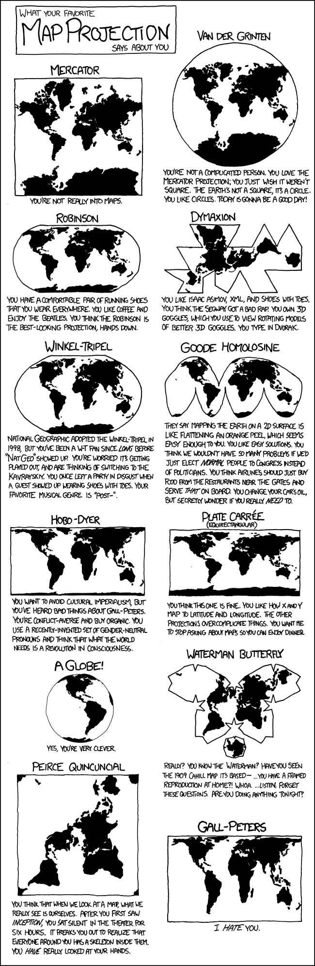
It gets even more fun when you get into surveying and other issues that require you to deal with the fact that the earth isn't flat even on a small scale. Google 'cartography AND "state plane"' and make sure you're wearing a hat to contain the mess when your head explodes.
USGS publishes the map projections Bible, free these days as PDF. I've kept a copy on my desk for years. Snyder, "Map Projections: A Working Manual"
I know little about surveying, but reading a book about the work done between 1763 and 1767 by Charles Mason and Jeremiah Dixon gave me some fascinating insight on how they established their famous line and performed other difficult surveying tasks around the Delaware-Pennsylvania border.
They had to clear a path through the Great American Forest for over 200 miles to accurately survey the line. When standing on a mountain in its path one could see the curvature of the line, as it followed a true longitudinal arc.
I found the book very interesting.
http://www.amazon.com/gp/search?index=books&linkCode=qs&keywords=0471437042
If you want a great education in mountain flying stand in a creek among some big rocks and watch the water and what it does, where the eddys form.... The wind through the mountains behaves much the same. Many times in bad conditions in the mountains, the best place to be is with a wing tip dragging the side of a mountain in the boundary layer.
Pilawt
Final Approach
- Joined
- Sep 19, 2005
- Messages
- 9,481
- Display Name
Display name:
Pilawt
A few years ago -- before I had a smartphone with GPS -- I took my Lowrance 100 GPS along on a Mediterranean cruise. While we were docked at Istanbul I punched in "direct-to" my home field, which lies just across the river from Portland, Oregon. Here's the display of the course it plotted:


