The Great Circle?

John Baker

Final Approach
Joined
Oct 4, 2008
Messages
7,471
Location
San Diego, California
Display Name

Display name:
John Baker
One of the things that went zipping over my head in ground school years ago was the explanation of "The Great Circle." I can not recall if it was a complex thing or if I was simply tired after working all day.

This is more out of curiosity than having anything to do with flying an airplane, since I haven't been doing much of that lately. I've been thinking about flying with a CFI in multi engine planes next month, again to satisfy curiosity more than getting a rating.

Anyway, can any of you experts splain the great circle in such a way that even the lowest common denominator might be able to grasp the concept?

Thanks,

-John
 
I may be wrong but it is a concept that you can figure out the shortest distance between any two point on the earth by using the longitude and latitude of the two points and plugging them into a formula. It makes a few assumptions such as the earth is a perfect sphere and a rounding of the radius of the earth so it is an approximation(though fairly accurate) of the distance. I would suspect that moving maps use the formula to determine distances as well, but I may be wrong about that. Also the distance will need to be increased base on MSL, but my understanding is that is also a fairly small difference as well.

The formula is available on-line on a number of sites for example:
http://www.movable-type.co.uk/scripts/latlong.html.

Doug
 
You mean what a great circle is?

Take two endpoints on the surface of the earth. Draw another one at the center of the earth.

Three points determine a plane. The intersection of that plane with the surface of the earth is a great circle (precisely for a spherical earth, approximately for a spheroidal earth). There are two great circles given two endpoints, but people almost always choose the shorter one.

You'll find this much easier to visualize with a globe, rather than a flat map. The globe will make it obvious why a great circle is the shortest distance on the sphere. Most commonly used map projections distort great circles substantially (the exception is the gnomonic projection, which represents great circles as straight lines, but it's not used much because it distorts areas).

I'd suggest going the geometrical route before trying out the spherical trig formulae, but YMMV.
 
Last edited:
Simply go to a globe. Stretch a string between any two points on the globe. The path of the stretched string is the great circle route between those two points. If you try to represent the globe as a flat map, the path of the string turns into a curve unless it is on the equator.
 
Simply go to a globe. Stretch a string between any two points on the globe. The path of the stretched string is the great circle route between those two points. If you try to represent the globe as a flat map, the path of the string turns into a curve unless it is on the equator.
Exactly right... I usually use my daughter's globe that she does not need anymore, a thread and pins. This works great to verify the locations of drop zones for expended booster stages of space carrier rockets and ICBMs. I suppose I should find some software to do it but I'm too lazy and crusty in my ways.
 
MAKG's explanation is very precise and mathematical, but if you want an example that might be more intuitive, go into SkyVector and plot a direct course from KMFV to KSFO, clear across the continental US. Those two fields are at almost exactly the same latitude (about 37.5), i.e. KSFO is due west of KMFV. What you get for the course isn't due west but a big arc on the map, with an initial track of 285* true and it's noticeably north of west. It's a great circle route, which runs generally north of the 37.5 parallel. You can follow it across the country where it levels off just north of the 40th parallel in Nebraska, and eventually angles into KSFO from the NE. That's because going between those two points along a parallel of latitude (i.e. due west) is actually a longer distance (I'm too lazy right now to figure out exactly how much longer). That's generally true, that the shortest distance between any two points on the surface is a great circle route. As MAKG said, it's easiest to see this on a globe.

An extreme example would be if the two points were closer to the north pole and on opposite sides of the Earth (180 degree difference in longitude). In that case it would be obvious that the shortest distance between them is across the north pole.
 
An extreme example would be if the two points were closer to the north pole and on opposite sides of the Earth (180 degree difference in longitude). In that case it would be obvious that the shortest distance between them is across the north pole.

They don't need to be closer to the pole. Any pair of cities not on the equator, and on equal latitudes and opposite longitudes will do.

For example, Reno to Tehran.

I didn't know skyvector did great circles. That's an error. Compass headings are not close to great circles over large distances.
 
Last edited:
Great circle, shortest distance between 2 points on the surface of a sphere.

Use any online mission planner, who would think that a direct, shortest distance flight from LAS to AUG, Las Vegas NV to Augusta Maine, would go through the great lakes.

More of a factor with distances over 300 miles. Great circle from Seattle to London is over the poles. Go north to go east.

Consider the opposite, when you move that sphere to a flat map, the lines of latitude are curved. On a sphere they are straight and parralle.
 
They don't need to be closer to the pole. Any pair of cities not on the equator, and on equal latitudes and opposite longitudes will do.

For example, Reno to Tehran.
I agree -- but it's easier to see without taking a string and measuring on the globe. As you said, the two points can't be on the equator because on the equator, the difference between the routes is zero (for a sphere, of course). It becomes larger towards the poles, approaching the limit (pi/2 - 1)*d.

I didn't know skyvector did great circles. That's an error. Compass headings are not close to great circles over large distances.
What's the error? What is that course if not a great circle? I'm pretty sure the compass heading is only intended to be the initial heading.
 
Last edited:
You can show why a great circle is shorter too . ..

Take a piece of dental floss.

Trace a great circle route on a globe. Cut the floss so it is no longer than the great circle route.

Take the floss to same scale flat map. Stretch the floss from point A to B - it will not be long enough.
 
What's the error? What is that course if not a great circle? I'm pretty sure the compass heading is only intended to be the initial heading.

That's what they did.

When navigating with a compass, you follow a "rhumb line" -- a line of constant course. These are not the shortest distance, but you can follow them without knowing exactly where you are on the trajectory. It's the history behind the Mercator projection (which projects all rhumb lines as straight lines). All rhumb lines except those exactly true east or west follow a spiral trajectory on the globe, terminating at one of the poles.

If you don't have a GPS, following a great circle is difficult. Following a rhumb line is much less so.
 
You can show why a great circle is shorter too . ..

Take a piece of dental floss.

Trace a great circle route on a globe. Cut the floss so it is no longer than the great circle route.

Take the floss to same scale flat map. Stretch the floss from point A to B - it will not be long enough.

You're right, but in practice, it's really difficult to find a globe and a flat map at the same scale (even at one point).
 
The website www.gcmap.com is fun to play around with. I do a lot of my initial "what if" planning with it.

gcmap is a great little tool. It's especially interesting when looking at a route like PDX-LES (that's Lesotho). You'd think that a route going from the northern US to the southern bit of Africa would go south, right? Nope! You actually go a bit north first.
 
If you don't have a GPS, following a great circle is difficult. Following a rhumb line is much less so.
I don't think skyvector wants you to use their flight planned courses for navigation. ;) (isn't there a disclaimer on the site to that effect?) Just as ATC seems to assume that everyone has a GPS today, I think skyvector does too.
 
gcmap is a great little tool. It's especially interesting when looking at a route like PDX-LES (that's Lesotho). You'd think that a route going from the northern US to the southern bit of Africa would go south, right? Nope! You actually go a bit north first.

The thing that gets me always is the long legs before you change direction and then when you change direction it changes fast and at hard angles and then its another long basically straight leg on a flat map . . .
 
If you don't have a GPS, following a great circle is difficult. Following a rhumb line is much less so.

Lindbergh charted his route with segments, every 100 miles, or once an hour he would change course a set number of degrees to the right. Nothing new there, ships had been doing it for centuries ever since we figured out the world wasn't flat.
 
The way I explain it:
Maps are flat, the Earth isn't. Get an Orange or a Grapefruit. Use a permanent marker to draw a straight line from near the top of the fruit to the bottom. Peel it while trying to keep it as in-tact as possible. Flatten it so it's like a map. Your straight line will appear to be curved on the "flat map."
This curve is effectively a straight-line from Point A to Point B on a curved surface. This is a Great Circle.

You can do the same in reverse. Flatten the orange peel like a map, draw a straight line, then let it form back into a sphere and you'll have a line that is bent between points A and B instead of direct. Hopefully this helps.
 
Foreflight also does Great Circle routing... Note the arc...

u2ezanaq.jpg
 
Lindbergh charted his route with segments, every 100 miles, or once an hour he would change course a set number of degrees to the right. Nothing new there, ships had been doing it for centuries ever since we figured out the world wasn't flat.
This is very true....in fact, Lindbergh got the idea upon seeing a great circle nautical chart in a shop in Southern California. That chart was what he used to come up with the individual waypoints for his rhumb lines.

FWIW, it is incorrect to say you can't plot a great circle on a 'flat map'. It all depends on the projection used to create the chart. It is true for most maps and charts which tend to be based on Mercator projections, however on a Gnomic projection like Lindbergh used, you can indeed plot a great circle as a straight line on a 'flat' chart.
 
You can show why a great circle is shorter too . ..

Take a piece of dental floss.

Trace a great circle route on a globe. Cut the floss so it is no longer than the great circle route.

Take the floss to same scale flat map. Stretch the floss from point A to B - it will not be long enough.

Don't switch to a map. Use two cities on the same latitude on the globe and it is obvious it takes more floss to trace the latitude line instead of the great circle.
 
Take the floss to same scale flat map.

it's nearly impossible for a globe and a flat map to be same scale except at one latitude.

Even those Flat maps with curved lines of latitude have significant errors of scale near the margins. They're typically not drawn to exact scale because they'd look too weird.

And, if a flat map was drawn to perfect scale, then a straight line on that map would also represent the great circle "arc".
 
Last edited:
it's nearly impossible for a globe and a flat map to be same scale except at one latitude.
That's not true. It depends on the projection. If you use an equal-area projection, the scale is very constant at the expense of the angles being wrong.
Your lambert sectional chart on the other hand is an equal angle chart. very handy for getting headings right and fortuantely the scale is big enough that the scale errors from top to bottom aren't that bad. You can see what they are by looking at the scales they provide on the margin of the chart.
 
Look at the north (or south) pole. Mark two spots a mile away opposite from each other. Which is shorter - to fly straight north and then south (2 miles) or to fly at a constant heading (making a semi circle - about 3.14 miles).
 
Does anyone remember the episode of the West Wing where CJ Cregg gets her mind blown by the map people? That's a bit how I feel any time I think about this.

Intellectually I understand that paper maps are flat, and the Earth is not. But I always struggle with really believing that it's quicker to go North to end up South (per the PDX-LES example). I think the thing is that we have two basic truths that have been hammered into us since grade school in conflict here:

* Maps are accurate representations of the Earth.
vs.
*The shortest distance between two points is a straight line.

The more I learn about the internals of cartography, the more I realize the first assertion is false.
 
* Maps are accurate representations of the Earth.
vs.
*The shortest distance between two points is a straight line.

The more I learn about the internals of cartography, the more I realize the first assertion is false.

So is the second.

It gets even more fun when you get into surveying and other issues that require you to deal with the fact that the earth isn't flat even on a small scale. Google 'cartography AND "state plane"' and make sure you're wearing a hat to contain the mess when your head explodes.

USGS publishes the map projections Bible, free these days as PDF. I've kept a copy on my desk for years. Snyder, "Map Projections: A Working Manual"
 
I think the thing is that we have two basic truths that have been hammered into us since grade school in conflict here:

Those truths are right. What they do is classic oversimplification of the facts while leaving out relevant information and pretending the new representation is reality.

* Maps are accurate representations of the Earth.

It's a 2D drawing of a 3D surface.
The same problem occurs in a perspective drawing. Two objects in a drawing appear to be a foot apart yet the depth of the drawing toward the vanishing point is half a mile.

*The shortest distance between two points is a straight line.

It is. The problem is that the 2D image does not take into account a real 3D sphere that has depth. The whole concept of a vanishing point to give 3D to a 2D surface does not exist on a map because the vanishing point (center of the earth) is physically off the plane of the map and can not be represented properly.


Understanding this is not about technological computerized nonsense or academic mathematical formulas. It's about kindergarten level geometry and not overthinking it.

Do this with a round globe and a map: (scale doesn't matter, just the 2D and 3D surfaces)

Pick a start and stop point. Something like NYC and Paris or some other points quite a distance apart. It has nothing to do with latitude or longitude lines at all, it's just about being a significant global distance apart.
Lay a piece of string on a 2D map to make a straight line between those locations. Pick a third point along that line. That straight string line is obviously the 2D map shortest route.
Put the string on a globe at the same start/end points with the string crossing that 3rd enroute point. The string is a certain length. You will also notice that it's quite loose on the globe when you're not pulling it tight at the midpoint.
Now forget about the midpoint location and pull the string tight and keep it at the start/end points. You end up shortening the string by a quite a bit and for the NYC/Paris route and the middle of the string moves way North of the 2D reference midpoint.
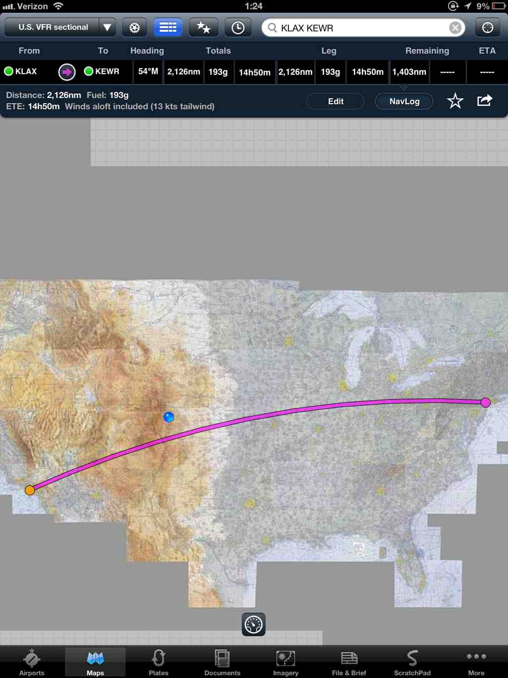
The straight tight string on the globe route is the shortest distance between two points on the surface of a globe. Plot those enroute points out on a 2D map and there's your mysterious confusing 2D great circle route.

Your typical FAA approved 50 mile XC has a great circle route. Walking the one step from the kitchen sink to the fridge does too. At those distances though, the added range on the 2D map to get there is irrelevant for real world operations.
 
however on a Gnomic projection like Lindbergh used, you can indeed plot a great circle as a straight line on a 'flat' chart.

It's "gnomonic." I've never actually seen a gnomonic projected map that I didn't make myself. The related stereographic projection is much, much more common, but it doesn't project great circles as straight lines.

I used gnomonic projections in my flight planner because plotting straight lines is faster than plotting curved lines, and it's also a lot easier to find intersections of flight segments with special use airspace boundaries. When these flight segments might be 3 or 4 hours of flight time, the difference between rhumb line and great circle ground tracks are substantial.

Its MAJOR drawback is that it cannot represent an entire hemisphere in finite area, and distortions more than 90 deg from the point of tangency are very severe.
 
Last edited:
Lindbergh charted his route with segments, every 100 miles, or once an hour he would change course a set number of degrees to the right. Nothing new there, ships had been doing it for centuries ever since we figured out the world wasn't flat.

No. Ships have been doing it since they figured out how to measure longitude, which was centuries AFTER Europeans rediscovered the spherical earth. You need a good clock -- or wireless radio signals -- to measure longitude. It has only been reliable and widely available for a century.
 
It's "gnomonic." I've never actually seen a gnomonic projected map that I didn't make myself. The related stereographic projection is much, much more common, but it doesn't project great circles as straight lines.
I have seen and used a few for nautical voyage planning back in the days before computer voyage planners. Back then they were pretty handy. Now, it is a lot easier to just use the computer.


Sent from my iPad using Tapatalk HD
 
No. Ships have been doing it since they figured out how to measure longitude, which was centuries AFTER Europeans rediscovered the spherical earth. You need a good clock -- or wireless radio signals -- to measure longitude. It has only been reliable and widely available for a century.
More like over two centuries. Ships have been doing it since the first reliable chronometer was developed in the late 18th century.


Sent from my iPad using Tapatalk HD
 
More like over two centuries. Ships have been doing it since the first reliable chronometer was developed in the late 18th century.


Sent from my iPad using Tapatalk HD

Yes, it's been available that long. But it didn't become ubiquitous until the wireless was invented.

But there still is almost 300 years of global navigation before that. And that was done following lines of latitude (small circles and rhumb lines), or coastlines. 700 years if you count what the Vikings were doing. They certainly made it halfway across the Atlantic to Iceland and Greenland, and may have made it all the way to Newfoundland, in the 11th century.
 
Last edited:
Does anyone remember the episode of the West Wing where CJ Cregg gets her mind blown by the map people? That's a bit how I feel any time I think about this.

Intellectually I understand that paper maps are flat, and the Earth is not. But I always struggle with really believing that it's quicker to go North to end up South (per the PDX-LES example). I think the thing is that we have two basic truths that have been hammered into us since grade school in conflict here:

* Maps are accurate representations of the Earth.
vs.
*The shortest distance between two points is a straight line.

The more I learn about the internals of cartography, the more I realize the first assertion is false.

Despite the curvature of a great circle route the shortest distance between two points is still a straight line. Unfortunately you can't go in a straight line from New York to London without digging a long tunnel.
 
I know I'm dating myself here! In OCS in 1983, in order to plot a GC route we were taught to use a gnomic projection chart to plot a GC route and then transpose the coordinates every 500 miles to a Mercator projection chart, to get the course to steer. This was back when in order to plot a LORAN fix one actually got the timing signals from the Loran and had to plot these on a chart with timing lines drawn. Nowadays they just use GPS I am sure.

For what its worth a sectional is a Lambert Conformal Conic projection, a straight line on that is pretty close to a GC route for how long your bladder will last!
 
Foreflight also does Great Circle routing... Note the arc...
Yep... Just did that last night for a flight from KVLL to KOAK (one of my fantasy XCs that I might do someday). I've always figured the southern route through NM and AZ didn't add too much to the distance... now I know better. In fact I found a route along airways through WY, UT, and NV that adds only about 30 nm over the great circle route, and where the highest MEA is only 12,000 (and most of the MEAs are only 9.5k to 11k). The southern route adds about 200nm to the total flight distance.

I'd still want a good course in mountain flying before trying it for real, though.
 
This was back when in order to plot a LORAN fix one actually got the timing signals from the Loran and had to plot these on a chart with timing lines drawn. Nowadays they just use GPS I am sure.
Ha, I remember those days....you had to manually interpolate between the grid lines in order to plot a fix on the chart. Then came Loran boxes that would do the interpolation for you and spit out the lat/long for you just like a gps.


Sent from my iPad using Tapatalk HD
 
Lot more experts than I had imagined. Thanks to all of you, I now understand the basics of a great circle. How this will change my life, I have no clue, but you never know.

It is fun leaning new things.

-John
 
One of the things that went zipping over my head in ground school years ago was the explanation of "The Great Circle." I can not recall if it was a complex thing or if I was simply tired after working all day.

This is more out of curiosity than having anything to do with flying an airplane, since I haven't been doing much of that lately. I've been thinking about flying with a CFI in multi engine planes next month, again to satisfy curiosity more than getting a rating.

Anyway, can any of you experts splain the great circle in such a way that even the lowest common denominator might be able to grasp the concept?

Thanks,

-John

Take a styrofoam sphere, take a straight edge and cut part way through the sphere, where the edge sliced through the surface is a 'Great Circle Route', it can also be demonstrated by connecting any 2 points on a globe with a piece of taught string. This will be the shortest distance between 2 points on the surface of a globe. This differs from a Rhumb Line which is a straight line on a Mercator Projection chart.
 
I'd still want a good course in mountain flying before trying it for real, though.

If you cross the Rockies in southern Wyoming (follow I-80), you can overfly all the peaks. Similarly, cross the Sierra Nevada at Lake Tahoe or further north. The highest peaks around there are about 10,000 feet. They get much higher further south.

A mountain course would be a good idea, but these routes are less than hard core. You do have to understand density altitude thoroughly, watch the weather (mountain obscuration over the Sierra often cannot be overflown in a small aircraft -- and it almost always means either ice or thunderstorms, or perhaps both -- and significant winds in the passes can cause severe turbulence) and plan your route according to terrain.

Mountain flying is a blast. Take the course if you get the chance. It's a good excuse to visit Colorado. It's offered just about everywhere in the West (even all over the Bay Area), but it might take a bit of time to get to "real" mountains. Coast Ranges top out under 5000 feet -- too trivial.
 
Back
Top