temperature and altimeter

Slackyhacky

Ejection Handle Pulled
Joined
Dec 27, 2014
Messages
54
Display Name

Display name:
Jeremy
Ugh...so many confusing explainations.

Can someone tell me like I'm 10 years old?

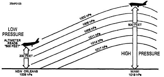
Let's assume I am sitting in my plane, at sea level at 15C - altimeter is reading zero as it should.

The temperature drops 30C to -15C.

What will my altimeter read relative to zero? I assume it will read less than zero now (cold air more dense, so heavier, so will put more pressure on the aneroid wafer in the altimeter - thus moving the needle to a lesser value). So, my indicated altitude is now lower than my actual altitude. However, this makes the saying "high to low, look out below" make no sense. Because if i were flying, and trying to keep my altitude at zero, as the temp changed lower, and the needle moved towards negative, I would make adjustments upward to keep the needle at 0. In other words, I would fly higher.
 
The saying "high to low, look out below" refers to both temperature and pressure.
Pressure from here http://meteorologytraining.tpub.com/14010/css/14010_203.htm:
14010_203_1.jpg

Temperature from here https://allaboutairplanes.wordpress.com/tag/altimeter-error/:
altimeter-temperature-effect.png


Density and pressure are 2 different concepts. It appears you are thinking of them as the same, they are not. The plane flies at a pressure the altimeter reads.

As the temperature decreases the air does get more dense but the pressure does not increase. So, in your example, when The temperature drops 30C to -15C the density increases but the pressure does not. Think of what happens in your tires when the temperature drops; the tire pressure decreases correct? This is explained by Gay-Lussacs gas law.

So, if The temperature drops 30C to -15C and the pressure decreases, your altimeter will read higher than your true altitude.
 
Last edited:
Just think of the airmass as a thing that contracts when it get colder and expands when it gets warmer. So, at a 5,000' indicated altitude at, say 30 deg C your radar altimeter (unaffected by temp) shows 5,833' and at -3 deg C it reads 4,112'.

Airports correct for this by giving an altimeter setting that just gives the desired elevation. As planes climb they start to deviate according to temp but they all deviate uniformly so it's a non-issue.
 
Forage,

I probably am am thinking erroneously. Density has both mass and volume, and air pressure is basically the mass (column of air above) correct?

Also, your tire example is a closed system. Unfortunately the column of air above my plane is an open system so ideal gas laws shouldn't apply.

So, with my plane at sea level, altimeter reads 0, the temp drops 30C, what will my altimeter now read (relative to zero)?
 
Thermodynamically, the atmosphere is frequently modeled as a closed system with a constant volume.

I hope that's the last time I ever have to say that in a pilot forum :)

Temperature varies uniformly for all airplanes, and is usually negligible compared to changes in pressure. It's not generally something to consider when flying...except for icing.
 
The original premise doesn't provide sufficient information, because you didn't tell us if the barometric pressure is the same before and after the temperature drop. If it's the same, the altimeter would read nothing different.

Now, chances are, the pressure would change as the temperature dropped.

The pressure would probably decrease, due to the colder temperature compressing the temperature lapse rate. The altimeter sees lower pressure, thinks it's at a higher altitude, and would show you to be above sea level.
 
Pressure and Density are NOT THE SAME! The density can change, and the pressure stays the same. The column of air can shrink in height, it is more dense, but the same weight, same pressure.

The atmosphere is held to the earth by gravity. It is NOT a closed volume. The top of the atmosphere moves up and down. Think of the column of air as capped by a sheet metal top, attached to earth by a spring.
 
Okay. I thought of a way for me to think about it that makes sense to me. The graph above helped.

If we think of a column of air with 100 molecules or units, and at a standard defined temp, each molecule of air corresponds to the same height. So molecule 1 sits at height 1. Molecule 60 sits at height 60, etc. An altimeter or height meter is nothing more than a molecule counter (number of molecules below the plane) in my example. So as my plane sits at height 60, there are 60 molecules below it, my altimeter reads 60. Temperature drops and my column of air will shrink. Now molecule 100 is at height 80. If my plane stays in the column of air and still sits on molecule 60, my altimeter will still read 60, but actual height will be less, maybe 45.

Now, if I fix my plane at height 60 and temp drops, the column of air shrinks, and now I may have 80 molecules beneath my plane, so altimeter reads 80, but actual height is 60.

Opposite happens for increased temp - column of air expands.
 
Last edited:
Okay. I thought of a way for me to think about it that makes sense to me. The graph above helped.

If we think of a column of air with 100 molecules or units, and at a standard defined temp, each molecule of air corresponds to the same height. So molecule 1 sits at height 1. Molecule 60 sits at height 60, etc. an altimeter or height meter is nothing more than a molecule counter (number of molecules below the plane) in my example. So as my plane sits at height 60, there are 60 molecules below it, my altimeter reads 60. Temperature drops and my column of air will shrink. Now molecule 100 is at height 80. If my plane stays in the column of air and still sits on molecule 60, my altimeter will still read 60, but actual height will be less, maybe 45.

Now, if I fix my plane at height 60 and temp drops, the column of air shrinks, and now I may have 80 molecules beneath my plane, so altimeter reads 80, but actual height is 60.

Opposite happens for increased temp - column of air expands.

In your analogy you are correct.
 
Pressure or temps have nothing to do with altitude. This archaic way of altitude measurement drive me nuts. GPS is accurate to within 3 -7 feet regardless of pressure or temp. Someday, the instruments we use will be as accurate in all conditions as GPS is every day right now.

Someday, we will look at pressure altimeters like we do the rotary phone, cassette players, VCRs, and a land line, and throw them all in a telephone booth where they belong. ;)

This is 2015 and we are still using the pressure altimeter as our main source for reporting altitude. :rolleyes:
 
Last edited:
And that makes high to low look out below make sense.
 
As the temperature drops 30C to -15C you would get a new local altimeter and with the new correct altimeter you would adjust back to 0'.
 
As long as you set your altimeter to the sea level pressure (SLP) setting where you are, your altimeter will read accurately regardless of temperature. The only time errors are introduced by temperature is when you are not at the same place where the SLP reading was taken. What happens is the pressure lapse rate increases as temperature decreases, so the normal lapse rate "programmed" into your altimeter results in the altimeter errors discussed. For any given nonstandard temperature, those errors increase as your height above the station where the SLP reading was taken (or below, too, but below isn't usually an issue), but decrease to zero as your height above that station decreases to zero. You can see the effect of this in the altimeter temperature correction table in the AIM.
 
Pressure or temps have nothing to do with altitude. This archaic way of measurement of altitude drive me nuts. GPS is accurate to within 3 -7 feet regardless of pressure or temp. Someday, the instruments we use will be as accurate in all conditions as GPS is every day right now.


That statement assumes a few things...

1. Enough satellites being received and sending correct orbital correction data.
2. The "height" number is above the GPS spheroid and the planet isn't the spheroid.
3. The GPS signal is WAAS corrected for higher accuracy.
4. The height is otherwise referenced to the planet in some fashion.
 
Thanks for the responses.
Here is the practice test question that promoted my confusion.

How do variations in temperature affect altimeter?

A. Pressure levels are raised in warm days and indicated altitude is lower than true altitude.
B. Higher temperature expands the pressure levels and the indicated altitude is higher than true altitude.
C. Lower temperatures lower the pressure levels and indicated altitude is lower than true altitude.

Answer is A. I couldn't resolve in my head (and still can't) how pressure is raised on a warm day (except if I think of earth as a closed system).
 
That isn't a practical test question, that is a knowledge question. This is why you are getting two different types of answers..
 
Thanks for the responses.
Here is the practice test question that promoted my confusion.

How do variations in temperature affect altimeter?

A. Pressure levels are raised in warm days and indicated altitude is lower than true altitude.
B. Higher temperature expands the pressure levels and the indicated altitude is higher than true altitude.
C. Lower temperatures lower the pressure levels and indicated altitude is lower than true altitude.

Answer is A. I couldn't resolve in my head (and still can't) how pressure is raised on a warm day (except if I think of earth as a closed system).

Well there's your problem. B is the correct answer.
 
Hi,

Why is C not correct? B and C seem to be saying the same thing??
 
Hi,

Why is C not correct? B and C seem to be saying the same thing??

If B and C are saying the same thing how could only one be correct?

:)
 
Last edited:
To be clear, A is the correct answer.

The question is presuming that you're at a higher elevation than the weather station you've set your altimeter to. Your airplane is higher than the weather station, so it's reading lower pressures. The altimeter converts that to an altitude reading.

The rate that pressure decreases with altitude is called the lapse rate. The greater the lapse rate, the bigger the difference in pressure between two different altitudes. Cold temperatures compress the pressure levels (raises the lapse rate) which means that the pressure decrease with altitude is greater.

If the pressure levels are more compressed than normal (higher lapse rate), anything above the weather station will read a lower pressure than normal. This tricks the altimeter into thinking it's higher than it is.

Anyways, we could offer 100 explanations, but it all comes down to understanding pressure lapse rate and the affect temperature has on it.
 
A is the correct answer.
 
Thanks for the responses.
Here is the practice test question that promoted my confusion.

How do variations in temperature affect altimeter?

A. Pressure levels are raised in warm days and indicated altitude is lower than true altitude.
B. Higher temperature expands the pressure levels and the indicated altitude is higher than true altitude.
C. Lower temperatures lower the pressure levels and indicated altitude is lower than true altitude.

Answer is A. I couldn't resolve in my head (and still can't) how pressure is raised on a warm day (except if I think of earth as a closed system).
Perhaps you are thinking that as the temperature increases the volume of air increases with no corresponding change in pressure because the earth is an open system. In reality there are local variations in pressure which are in constant flux towards equilibrium. As a local air mass is heated, it expands, its pressure increases until eventually the higher pressure air mass either contracts or moves towards an area of lower pressure.
 
Wow. OK, after reading the question a dozen times I get it.
Thanks.
 
Well there's your problem. B is the correct answer.
Remind me not to go flying any actual instrument approaches with you on really cold days. I'd suggest you re-read that AIM section I linked above before you head into Canada (or even the US Northern Tier) this winter.
 
Remind me not to go flying any actual instrument approaches with you on really cold days. I'd suggest you re-read that AIM section I linked above before you head into Canada (or even the US Northern Tier) this winter.

Maybe a smiley face would have helped. I'm quite familiar with cold weather approaches.
 
Then you knew Answer A was correct, but told the OP otherwise. Trying to figure out how you find that funny.

It's dry humor. The way you said it, you're right, isn't funny.
 
Someone read the Cold Temp altimetry corrections in the NTAP and went, what???
 
Back
Top