I haven't gotten the chance to fly into Tangier (yet), but I've been there twice--once for about two hours when on a trip to the Chesapeake Bay Foundation's Port Isobel Island next door, and once overnight with the family. You come away either absolutely loving or absolutely hating it. I happen to fall into the "loving it" category.
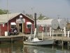
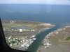
Don't go in expecting to see a quaint little New England-style fishing village. This is a working town, and though the residents definitely take pride in their town, it can look a little run down in spots. You can rent bikes or a golf cart, but I'd suggest walking, because the island really isn't that big. You'll be able to see all of it on foot in a day. Definitely bring a camera, because the whole island--the village, the marshes outside the town, the beach, etc.--is very picturesque.
Speaking of the beach, it's definitely worth your time to go out on it. We walked all the way to the tip of it and saw virtually nobody else. It's easily one of the most beautiful beaches I've seen. Don't go swimming later in the summer, though, because the stinging jellies move up from the Bay as the summer goes on. Not fun.
I think Spanky's, the 1950s style ice cream parlor, should be open, but I'm not really sure. It's worth it to go. I'm (unfortunately) somewhat allergic to shellfish, so I don't get to experience the fresh crabs, but everyone I know says they're amazing--the crabcakes in particular. There are several places to eat, and I've heard great things about the Chesapeake House, though I've never actually visited. It's a bed and breakfast that has a restaurant. Everything is early on the island, including at the Chesapeake House (the last seating for the "family style" dinner is around 5:00 PM), because the watermen get up at insane hours (like 3:00 AM) to tend to the crabs and get out on the water.
Other random things--they speak with a sort of Cornish accent because of their isolation. The phrase "high tide" comes out "hoi toide," for example. It's really pretty cool. Also, there are stray cats everywhere. And there are no ATMs on the island either, so you'll want cash.
I'm sure I'm forgetting some things, so I'll add to this later. Maybe. If I can think of anything to add. Ask questions too if you like. It's definitely worth a visit--so beautiful and serene, and also really unique.