JOhnH
Touchdown! Greaser!
We flew the Bo up to KMFY and are spending a few days on Chincoteague island. We are planning a lunch run to Tangier Island for some crabs on Sunday if any wants to join us.
And I have a question for the locals:
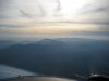
We were over the Bay at 9500. METARS said visibility 10 miles and Clear below 12,000. But the haze was so thick we couldn't see anything. We couldn't see the water or the horizon or even clouds. It felt like IMC. Was that because there just wasn't anything to see? When we began our descent we could start to make out the horizon and feland features. It was our first time that far out over water.
And I have a question for the locals:
We were over the Bay at 9500. METARS said visibility 10 miles and Clear below 12,000. But the haze was so thick we couldn't see anything. We couldn't see the water or the horizon or even clouds. It felt like IMC. Was that because there just wasn't anything to see? When we began our descent we could start to make out the horizon and feland features. It was our first time that far out over water.
")