
You are using an out of date browser. It may not display this or other websites correctly.
You should upgrade or use an alternative browser.
You should upgrade or use an alternative browser.
skyvector for nautical charts?
- Thread starter GeorgeC
- Start date

eman1200
Touchdown! Greaser!

- Joined
- May 25, 2006
- Messages
- 21,997
- Location
- KTTA, North Carolina
- Display Name
- Who you kiddin?
- Home Airfield
- KTTA
Don't encourage him.you da man
eman1200
Touchdown! Greaser!


Dare I mention.....Jeppesen.openseamap isn't doing it for me; is there something like skyvector for NOAA nautical charts?

- Joined
- Dec 5, 2010
- Messages
- 6,581
- Display Name
- GeorgeC

The ONION's 1997 Man of The Year
Each year, The Onion’s esteemed Board of Directors faces the daunting task of singling out one individual who most embodies the spirit of the times, who is most deserving of the title "Man Of The Year."
 theonion.com

Sac Arrow
Touchdown! Greaser!
- Joined
- May 11, 2010
- Messages
- 21,565
- Location
- Charlotte, NC
- Display Name
- Snorting his way across the USA
Glad I could help.you da man

schmookeeg
Final Approach
- Joined
- Nov 6, 2008
- Messages
- 5,812
- Location
- Alameda, CA
- Display Name
- Mike Brannigan
- Home Airfield
- KOAK
Boat charts are really uggo compared to ours.
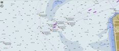
I love that they need to chart "mud" being under the water. Clearly there's a subtlety I'm ignorant of but it made me laugh anyway.
I love that they need to chart "mud" being under the water. Clearly there's a subtlety I'm ignorant of but it made me laugh anyway.

Ed Haywood
Final Approach
When I was into boating, Navionics was by far the best. They were uploading boater fishfinder data to create hyper-accurate bottom scans of popular bodies of water. They had good web based charts that you could access without a subscription.
The Borg assimilated them in 2017. I think they killed the web access in favor of subscription apps, because that's how Garmin rolls.
The Borg assimilated them in 2017. I think they killed the web access in favor of subscription apps, because that's how Garmin rolls.
Ed Haywood
Final Approach
Boat charts are really uggo compared to ours.
View attachment 144777
I love that they need to chart "mud" being under the water. Clearly there's a subtlety I'm ignorant of but it made me laugh anyway.
Useful info for anchoring. Also helpful for adjusting and interpreting fishfinders.
Brad W
En-Route
click the "stack of papers" icon top right, to select sonar or nautical
Brad W
En-Route
I'm not sure, but I think what Garmin buried under subscription was navigation tools. Used to be able to plan routes with it. Now I see no tools other than a crude pair of dividers