Tom-D
Taxi to Parking
- Joined
- Feb 23, 2005
- Messages
- 34,740
- Display Name
Display name:
Tom-D
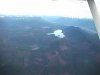
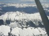
As most here know I live in Puget Sound, any way out of here is thru a pass or south around the mountains.
what is a safe altitude to transit the passes like Stevens? or Snoqualime ?
This is a vfr question I know what the MEAs are.
How close to the trucks can you go?
what is a safe altitude to transit the passes like Stevens? or Snoqualime ?
This is a vfr question I know what the MEAs are.
How close to the trucks can you go?

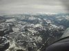
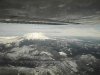
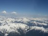
 ). This is also the reason for approaching ridges at a 45* angle, so that you can turn towards lowering terrain quickly and fly out of a downdraft should you encounter one.