Jaybird180
Final Approach
I am planning a trip during the 2nd week in September. I have plenty of time
to decide between driving or flying. I would like to have my IR by then,
which would then put odds more in favor of flying.
As I began to take a look at the route of flight, I realized that I do not
have as good an understanding of the topological depictions on the VFR charts
and proper altitude selection (I tend to plan too high), and so turn to my
forum siblings to help shore up my knowledge.
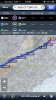
The proposed route of flight is: W00-OTT-BRV-GVE-ODR-(perhaps
PSK-KMKJ-KVJI-KTRI to avoid extra exposure to what looks to be high
terrain)KGKT (destination). My deviation looks like it keeps me out of the
rocks, but what if I decide to cut through? I don't think direct ODR-KGKT is
all that helpful, as the deviation is only calculated to cost 1 minute (no
wind) or 13 mins (current winds) at the time of typing this message.
Attached is a screenshot showing the route of flight with the longest leg at
96nm.
Skyvector.com wonderfully showed me that mountain obscuration may be a factor
during this flight, and I think I also can expect IMC conditions if I attempt
to remain above the block obstacle altitudes (there's a better name for this)
as depicted on the VFR sectional for terrain clearance. A review of the IFR
charts indicate I should be able to do the trip at 6500 VFR cruising altitude.
In September, should I favor taking this trip early morning, or can I expect
late morning/ early afternoon flying to be better? What if I return at night?
Can I expect to have a VFR-IMC encounter?
Thoughts on this plan and route?
to decide between driving or flying. I would like to have my IR by then,
which would then put odds more in favor of flying.
As I began to take a look at the route of flight, I realized that I do not
have as good an understanding of the topological depictions on the VFR charts
and proper altitude selection (I tend to plan too high), and so turn to my
forum siblings to help shore up my knowledge.
The proposed route of flight is: W00-OTT-BRV-GVE-ODR-(perhaps
PSK-KMKJ-KVJI-KTRI to avoid extra exposure to what looks to be high
terrain)KGKT (destination). My deviation looks like it keeps me out of the
rocks, but what if I decide to cut through? I don't think direct ODR-KGKT is
all that helpful, as the deviation is only calculated to cost 1 minute (no
wind) or 13 mins (current winds) at the time of typing this message.
Attached is a screenshot showing the route of flight with the longest leg at
96nm.
Skyvector.com wonderfully showed me that mountain obscuration may be a factor
during this flight, and I think I also can expect IMC conditions if I attempt
to remain above the block obstacle altitudes (there's a better name for this)
as depicted on the VFR sectional for terrain clearance. A review of the IFR
charts indicate I should be able to do the trip at 6500 VFR cruising altitude.
In September, should I favor taking this trip early morning, or can I expect
late morning/ early afternoon flying to be better? What if I return at night?
Can I expect to have a VFR-IMC encounter?
Thoughts on this plan and route?
") Not sure about better time, if you have kids maybe early morning so it'd be cooler and they may sleep. Be sure they don't bring any soda or processed food bags (see other thread on that)
Not sure about better time, if you have kids maybe early morning so it'd be cooler and they may sleep. Be sure they don't bring any soda or processed food bags (see other thread on that)