Pilot survives crash/forced landing in CO

denverpilot

Tied Down
Joined
Nov 8, 2009
Messages
55,469
Location
Denver, CO
Display Name

Display name:
DenverPilot
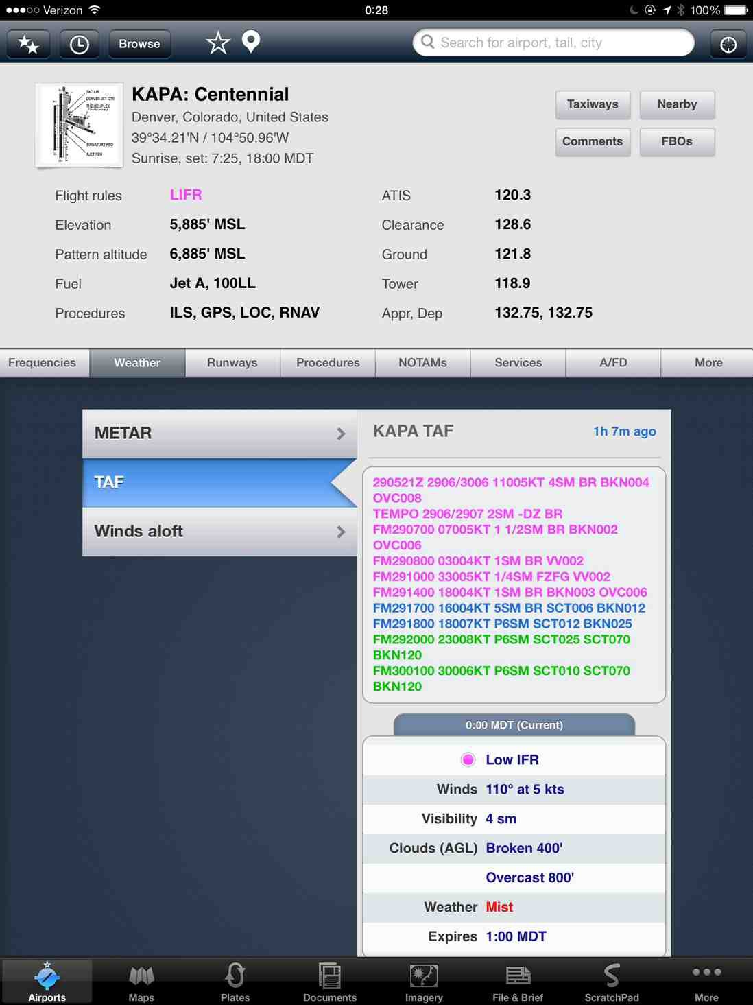
Not much news yet, but the weather here is decidedly sucky and has been all day... fog that was freezing to me while I was out walking the dog, came and went out here on the Eastern Plains all day long.

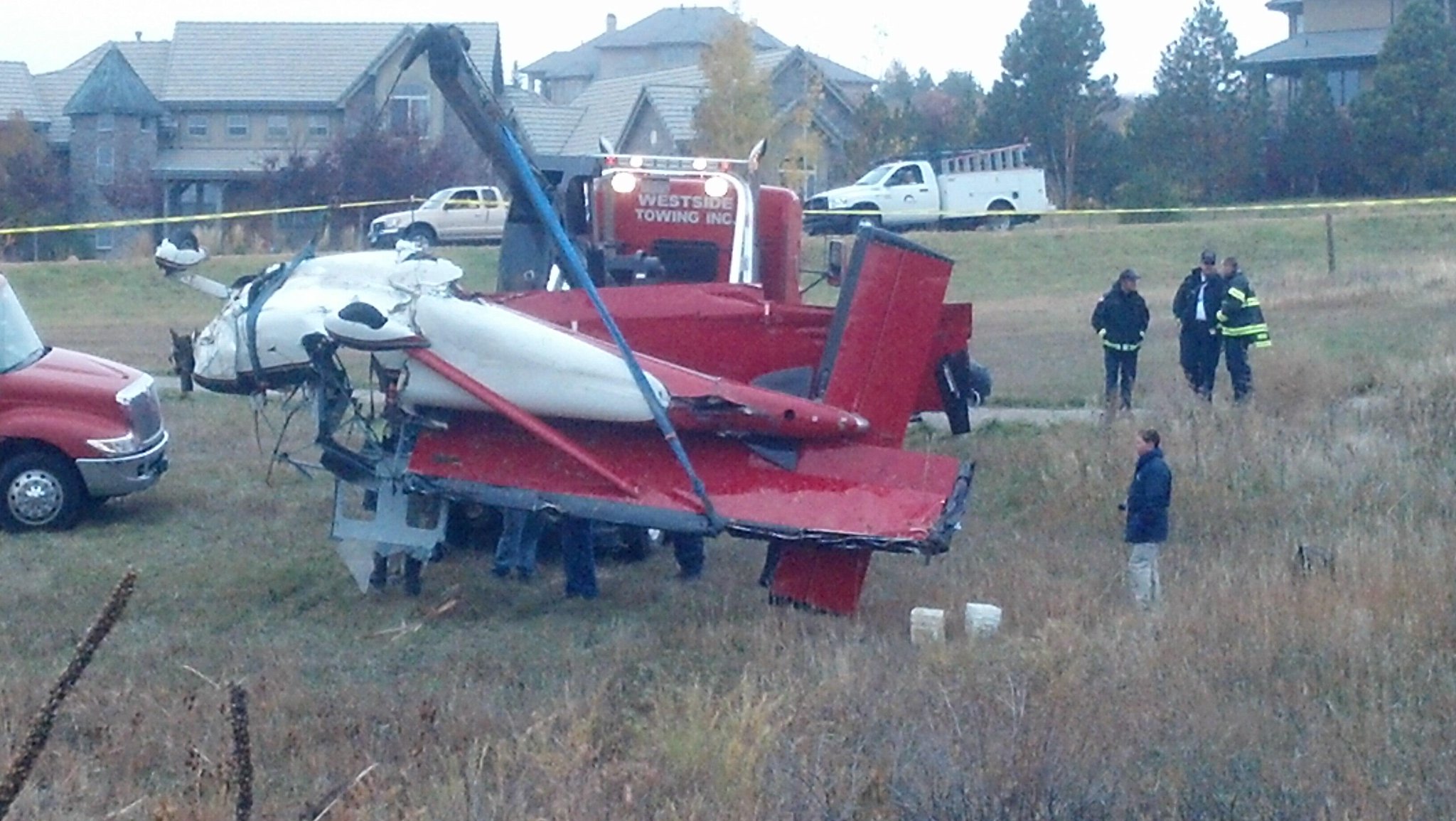
http://www.9news.com/news/article/362227/339/Single-engine-plane-crashes-in-Castle-Rock-

No clue what a pilot would be thinking with the weather reports the way they were around here today to be out in this crap in a single without FIKI, and even then...
 
That is one lucky girl.....:yes:..

Why she was flying in that crappy weather is going to be the 50,000 dollar question..
 
Seems like we get at least one that tries it, every Fall. It's almost like they just completely forget that the weather after Oct 1st almost always has some really awful ice days, and they get caught by one.
 
Well, if she was southbound, she wouldn't have found much better down here in Monument.....

It was clear around Colorado Springs when I left work earlier though...

Stupid.
 
They say that she reported icing to KAPA Tower... I suppose if I felt motivated I could go dig up the LiveATC archive... my feed is gone since I moved, but the other feed was still working when I packed it up and turned it off...
 
They say that she reported icing to KAPA Tower... I suppose if I felt motivated I could go dig up the LiveATC archive... my feed is gone since I moved, but the other feed was still working when I packed it up and turned it off...

I'm looking for it now. Wish there was a better way than to listen to an hour's worth of recordings between 0030 and 0130 Zulu ("around 7pm Mountain")
 
Last edited:
Interesting set of facts, as far as reported. Departed from Hayden but I can't find a flight plan. I would assume IFR, even in a Glastar, which is why she was down near Castle Rock, because that's the approach to 35R ILS. Does the FAA hide flight plans when there's an accident?
 
That guy's feed, his antenna is quite a ways out East if I remember correctly. He misses a lot of low level stuff to the south, which is where she was. My antenna had a better view of South and West, but couldn't hear jack past the airport to the East, so... it's all kinda a wash. If we had power/Internet at the hangar, I'd just put the puppy right on the field and a good antenna on top of the hangar.
 
Found it - the last 3 are 5SP, and it sounds like she did not declare an emergency. Reported icing "Light to Moderate Rime" at 7300ft.

ATC saw her climb to 7600 and asked if she could maintain altitude and gave her vectors to 270.

Still never got the pilot's side of the recordings, unfortunately. At 1:54, she was given an altitude alert for descending below MDA. Sounds like she was on an IFR flight plan.

At 1:57, she was told that she was descending below 6,800ft and given another altitude alert. There's a gap between the recordings, so I don't think there's anything after that unfortunately.
 
Interesting set of facts, as far as reported. Departed from Hayden but I can't find a flight plan. I would assume IFR, even in a Glastar, which is why she was down near Castle Rock, because that's the approach to 35R ILS. Does the FAA hide flight plans when there's an accident?

How do you find flight plans?
 
That's weird, FlightAware has SR20/G on it....does it not pull from the flight plan for that?

Flightaware and ATC still doesn't have explicit identifiers for the experimentals. Click on registration in flightaware and you can see the details.
 
Probably just had the type put in wrong by a controller. I'd go with the FAA DB on that one.

KFTG weather was REALLY crappy and it was FORECAST to be that crappy... what the HELL was she thinking? Last I looked this afternoon KFTG was freezing fog and 200 OVC. Good lord.

Heading 270 sounds like a really steep intercept for the ILS 35R at KAPA. They usually only do that if you're really close in and then knock the steep angle off right at the last second. Like aimed right at CASSE Westbound...

6800 is slightly below pattern altitude, and definitely below glideslope intercept... just before CASSE you're at 8000... and a missed you have to climb back to 7400 before turning...

Anyone figured out what road she tried to put it on? There's not much to land on out near CASSE other than I-25 and some County Roads east of the town of Castle Rock. Not a great place to be caught icing up.
 
P.S. I'm still laughing that the latest plate for the ILS 35R still shows that if you're vectored to FIRPI you're supposed to be no slower than 210 knots. LOL... I've reported that one before, and given up on it. When they re-did the ILS 35R plate and removed the transition route from FQF this summer, they seriously jacked up this plate. Most of the other egregious errors and omissions were fixed, and I've given up on getting the FIRPI thing fixed. I'd just refuse a vector or clearance to FIRPI if given one... LOL.
 
It's still just crappy out over there...

ereredeb.jpg
 
I got my PPL out at KAPA and let me tell you...not the right place to be stuck in icing conditions.

Field elevation is about 5,800 feet but just south of KAPA it's actually higher...like around 6,400-6,500 if I remember right. Just east of KAPA there's Parker Rd which runs N/S and is basically the main road on that side of the airport and there isn't much other that some residential roads until you hit I-25 which runs just west of KAPA and also runs N/S.

I'm guessing this is where Risk Management comes into play, and someone didn't do a very good job. Sorry :-(

Yesterday was not the day to be stuck with icing anywhere in the north half of Colorado, not just APA.

P
Actually, the risk management was reasonably good. Take a look at the flightaware track. Detoured south to avoid weather that was settled over central Denver to come around to get to Front Range. Realized the icing and immediately 180 to go to APA which was at most 5 miles away.

Of course the really poor decision was flying to Denver in the first place.

Local on the scene talking head reported "witness heard the engine stall then a boom". Why are we not surprised?
 
I think Glasair should require builders to put a placard in the airplane that states:

"Flight into probable icing conditions with your airplane that is not equipped with any sort of anti-icing equipment strongly discouraged" :lol:

Glad she's ok though.


Sent from my iPhone using Tapatalk
 
I found two photos of it and the more recent one shows it with the bush wheels. Prior pic was a few months earlier and it had tricycle gear...

887112.jpg


858640.jpg
 
I think Glasair should require builders to put a placard in the airplane that states:

"Flight into probable icing conditions with your airplane that is not equipped with any sort of anti-icing equipment strongly discouraged" :lol:

Glad she's ok though.

Single Engine, Night, IMC/IFR, Mountains...anybody see anything wrong with this picture?
 
One I never looked at. Too often the movie turns into a still picture.:sad:

I have made more than just a few trips in the northern Colorado Rockies. I understand the desire to complete the flight - I've made the flight from Hayden to FTG in a snowstorm but it was day VFR (yes, snow can be VFR) - sometimes ya just have to park it. I've driven from Wyoming to Denver a couple times already this year, it's not much fun but it's better than being in the paper.
 
she is very lucky to have made it out alive. i think next time she will think twice before trying to take off with wx and icing that bad
 
Just for curiosity I looked at the Skew-T sounding for yesterday evening.

GSD-Sounding-Plots.png


Maybe she thought she could make it through that layer quickly enough. However when you have those low clouds and upslope around here there is often icing. There was even icing on the trees this morning.
 
Just for curiosity I looked at the Skew-T sounding for yesterday evening.

Maybe she thought she could make it through that layer quickly enough. However when you have those low clouds and upslope around here there is often icing. There was even icing on the trees this morning.

Pretty telling with the temp/dew point convergence to the left of 0. The previous owner of the 'kota got a 709 after descending below glideslope while iced up...the current owner wants to avoid anything like that.
 
this plane crashed in my subdivision. The path they are standing on is a walking path that runs under these two large (and tall) sets of high tension wires. The elevation at my place is 6400 give or take a few. On either side of this ravine, the hill rises up fairly steep maybe 50-100. The weather was, like everywhere near me, crappy. Freezing fog, poor vis, etc. I saw the flash from when the power line impact came and thought at first it was from a strobe from some aircraft that was quite low on approach but then found out from the news what it actually was. Shes lucky to be alive and barely missed the house from the yard of the photo by about 50' or so. not sure if she iced up enough to not hold altitude or was just trying to find a spot to get sight, but the power lines made contact with the plane from all observations so far.
BXw1zoUCAAAs1vg.jpg:large
 
Name of the pilot was just posted.
http://www.9news.com/news/article/3...e-Rock-crash-IDd?odyssey=tab|topnews|bc|large

Helen Cernik
Date of Issue: 8/6/2012
Certificate: COMMERCIAL PILOT
Ratings:
COMMERCIAL PILOT
AIRPLANE SINGLE ENGINE LAND
AIRPLANE MULTIENGINE LAND
INSTRUMENT AIRPLANE

Address is in Washington state. Since the airplane is registered to Glasair, I'm thinking she's a sales/demo pilot, possibly delivering it.

Very likely she's very unfamiliar with Colorado geography and obviously didn't pay attention to the weather.
 
Looks like she had been a transition training pilot with them for a couple of years. This may be the same pilot who is a platinum certified trainer for cirrus and has - according to ferried in Europe and even to Hawaii.

-cirruspilots,org and theflightacademy.com

-here's hoping she heals up soon.
 
Looks like she had been a transition training pilot with them for a couple of years. This may be the same pilot who is a platinum certified trainer for cirrus and has - according to ferried in Europe and even to Hawaii.

-cirruspilots,org and theflightacademy.com

-here's hoping she heals up soon.

Huge difference between Glastar and a Cirrus. FIKI & altitude limits to start.

Article about her transition training at http://www.flyingmag.com/aircraft/pistons/glasair-sportsman

At last report she's still serious but stable. Fortunately, she landed close to homes and someone immediately went out to check, called 911 and stayed with her until help arrived.
 
Last edited:
Back
Top