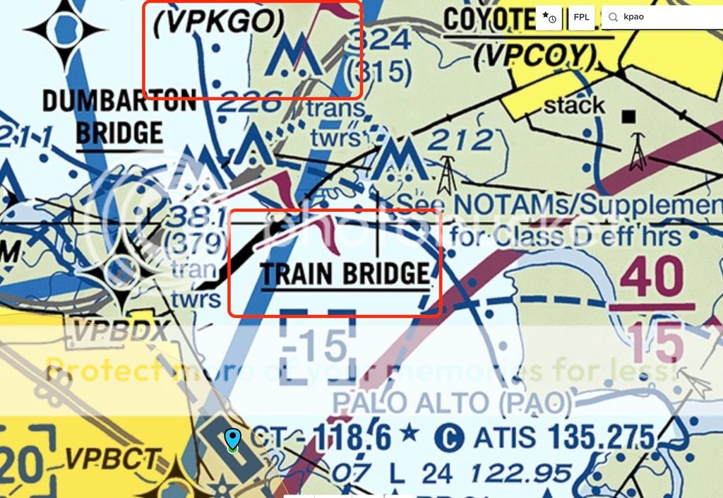
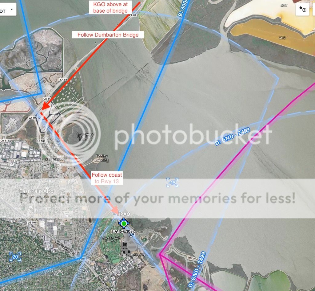
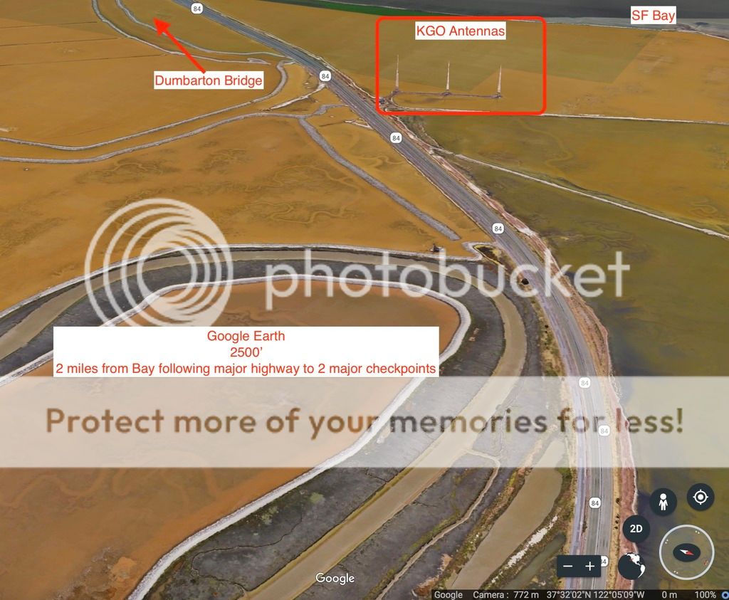
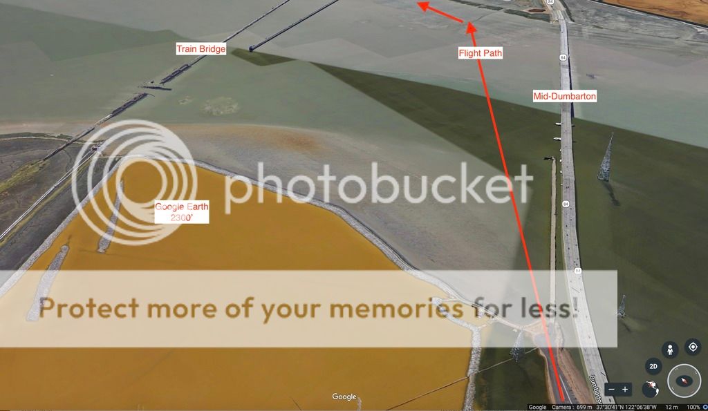
Mooney fatal at Palo Alto

Poor guy sounds like he was behind the aircraft. If someone's lost getting into the airport, he may also lost orientation for pre-landing procedures. I wish more pilots would just circle away and reproach when they are properly set up and ahead of the plane. Did this myself recently, and had a nice leisurely greaser landing.

Whenever I see a pilot overfly the field down the runway near pattern altitude... I to myself "this guy makes sense, good pilot".
 
I’m wondering if the airplane wasn’t completely clean with a fair amount of power when he finally saw the airport. By the time he throttled back, dropped the gear, and got the flaps down, he was probably far over the fence.
 
I’m wondering if the airplane wasn’t completely clean with a fair amounts fence of power when he finally saw the airport. By the time he throttled back, dropped the gear, and got the flaps down, he was probably far over the fence.

Maybe there wasn't a fence... just saying. :dunno: :rofl:
 
I'm based there, and I often find the airport via familiarity with nearby terrain features, especially the shape of the shoreline.
 
I'm based there, and I often find the airport via familiarity with nearby terrain features, especially the shape of the shoreline.

A couple times I had trouble spotting it when the golf course was finished! "Let's see... there's Moffett, there's... wait.. what is that? OH YEAH!"

Edit: but past that, it's not easily lost, especially in the day time. But if one is lost, it's one of those cases where a magenta line can really help out. Personally I think San Carlos is harder to spot.
I use the cement plant and the Oracle building complex to zero in on SQL.
 
Side note, I do miss that airport. When I moved down to San Diego I let the tower guys know it was my last flight out of there as my home base. Dude goes, "we should have rolled out water salute! Safe travels and see ya soon. Runway 13 cleared for take off"

Montgomery Field (San Diego) is nice, but I do miss the KPAO controllers. A truly great and professional bunch. The lady (I forgot her name... Sue? Francis? Eh, I'm just making **** up now) used to be based at Montgomery. Small world.
 
The PAO controllers certainly get a good workout on the weekends!
 
+1 on thumbs up for tower crew at KPAO. Also a shout out to KRHV Reid Hillview and KSNA Salinas.
 
I'm thinking this poor pilot did not have a VFR sectional handy. For those not familiar with Palo Alto KPAO here's the standard path coming from the East Bay. Check Point KGO is plainly marked and at the base of a major bridge (Dumbarton Bridge). The train bridge is also highlighted which is parallel to the Dumbarton.

To land on rwy 13, find KGO or where the bridge starts out over the water, follow the bridge, turn left on the coast and line up on compass heading 130.

KPAO_zpsgmove2ra.jpeg


KPAO2_zpsj8rdipdf.jpeg
 
Last edited:
I love how locals always thinks it’s easy.
Flying into SQL from the east I couldn’t find the cement towers, I didn’t know what a cement tower was, on top of that I was looking for traffic and trying to stay out of Bravo airspace, in the end I was given a heading and picked up the cement towers as I got closer. And this is without strangers sitting in the back.
 
To be honest in the approach environment in busy airspace I probably wouldn't have looked at the sectional to even know where/what the towers were. I've noticed on youtube a lot of CA controllers use local landmarks that aren't always defined on the sectional as a check point. This is a case where he let the controller fly the airplane and not him self. In fast airplanes planning ahead is key. I always try to get down to pattern altitude at least 5 miles or so before the airport so I can get slowed up and start looking for traffic.
 
In fast airplanes planning ahead is key. I always try to get down to pattern altitude at least 5 miles or so before the airport so I can get slowed up and start looking for traffic.

Same, high and fast is no way to enter the pattern in a Mooney.
 
.....This is a case where he let the controller fly the airplane and not him self....

to be fair, he called up tower and said he’s having trouble spotting the field and asked for a heading.
 
I love how locals always thinks it’s easy.
Flying into SQL from the east I couldn’t find the cement towers, I didn’t know what a cement tower was, on top of that I was looking for traffic and trying to stay out of Bravo airspace, in the end I was given a heading and picked up the cement towers as I got closer. And this is without strangers sitting in the back.
I certainly didn't mean to imply that spotting PAO is easy. To the contrary, even though I've been based there for my entire 27 years as a pilot, I acknowledged that I frequently have to rely on my familiarity with surrounding terrain features. I thought it was obvious that a new visitor would not have that level of familiarity.
 
To be honest in the approach environment in busy airspace I probably wouldn't have To be honest in the approach environment in busy airspace I probably wouldn't have looked at the sectional to even know where/what the towers were.looked at the sectional to even know where/what the towers were. I've noticed on youtube a lot of CA controllers use local landmarks that aren't always defined on the sectional as a check point. This is a case where he let the controller fly the airplane and not him self. In fast airplanes planning ahead is key. I always try to get down to pattern altitude at least 5 miles or so before the airport so I can get slowed up and start looking for traffic.

The Towers, KGO(VPKGO)are published on both the Sectional and TAC. They should have come as no surprise to him. By “To be honest in the approach environment in busy airspace I probably wouldn't have looked at the sectional to even know where/what the towers were” do you mean you literally wouldn’t look at the Chart when you are planning the flight and not have it when you were flying, either as paper in your lap or digitally on an IPAD or other similar device? It does seem that ‘maybe’ by not having familiarized himself with his planned flight he got in a situation where he didn’t do what would be some very good advice, as you said “I always try to get down to pattern altitude at least 5 miles or so before the airport so I can get slowed up and start looking for traffic.” The time spent on needing the controller to ‘navigate’ for him does ‘seem’ to have let ‘aviate’ get interfered with and led to getting behind the plane.

EDIT: This comes across as more accusatory of @Grum.Man than I intended it to be. See post #'s 58 and 65
 
Last edited:
The Towers, KGO(VPKGO)are published on both the Sectional and TAC. They should have come as no surprise to him. By “To be honest in the approach environment in busy airspace I probably wouldn't have looked at the sectional to even know where/what the towers were” do you mean you literally wouldn’t look at the Chart when you are planning the flight and not have it when you were flying, either as paper in your lap or digitally on an IPAD or other similar device? It does seem that ‘maybe’ by not having familiarized himself with his planned flight he got in a situation where he didn’t do what would be some very good advice, as you said “I always try to get down to pattern altitude at least 5 miles or so before the airport so I can get slowed up and start looking for traffic.” The time spent on needing the controller to ‘navigate’ for him does ‘seem’ to have let ‘aviate’ get interfered with and led to getting behind the plane.

Who there fella that isn't even close to what I said nice try though! But to repeat, aviate, navigate, communicate, in congested airspace you shouldn't be head down looking at a sectional or ipad as you are getting configured for landing. I guess we aren't all perfect aviators like you.
 
Check Point KGO is plainly marked and at the base of a major bridge (Dumbarton Bridge). The train bridge is also highlighted which is parallel to the Dumbarton

Looking at a sectional, for a pilot who was unfamiliar with the local airspace and procedures, I think classifying the checkpoint as "plainly marked" is a bit of a stretch. And even if he had a sectional, in that busy airspace, it would be too little to late to begin a game of "Where's Waldo." once in the traffic flow...
 
KGO isn’t the easiest to spot. Not sure how fast he was coming in, but if he’s screaming in over the bay it can be pretty easy to miss if you don’t know what you’re looking for. But tower told him to follow the bridge. Easy enough. Then coming in too fast.

Dude was just way behind the plane.

Very sad.
 
When flying into an unfamiliar airport and get a Visual Reporting Point that is not immediately obvious...”unfamiliar, request heading” is the first words outta my mouth. That is NOT the time to be searching for a landmark out the window or scanning a sectional.
 
When flying into an unfamiliar airport and get a Visual Reporting Point that is not immediately obvious...”unfamiliar, request heading” is the first words outta my mouth. That is NOT the time to be searching for a landmark out the window or scanning a sectional.
Nailed it. Hell, even flying into Palo Alto once earlier this year SJC tower said “proceed direct Pruneyard” ... my immediate response was “unfamiliar, can you give me vectors?”

I’m not looking that **** up in that situation.

Learned that the hard way, btw. I was flying the bay tour and OAK told me to head to the midspan of the San Mateo bridge. So I did. Then I got an abrupt “turn left heading blah blah”

Turns out the midspan is the middle of the lower, level part, not the midspan of the whole thing.

Of course it is marked and is a waypoint to plug into Garmin, but I didn’t know it at the time. So yeah, never assume and always get clarification if unfamiliar. Not the time to be digging through sectionals or searching on the MFD.
 
Just remember, it wasn't a bad runway that killed the pilot. It wasn't a long landing, a prop strike or a go around. What killed him was not keeping his airspeed up. Nothing more. Had he flown his Mooney into the crash he would have walked away. Mooneys are stout things.
 
Who there fella that isn't even close to what I said nice try though! But to repeat, aviate, navigate, communicate, in congested airspace you shouldn't be head down looking at a sectional or ipad as you are getting configured for landing. I guess we aren't all perfect aviators like you.


I can't agree with you more that that wasn't the time to be looking on a chart to find out where/what the towers are. "To be honest in the approach environment in busy airspace I probably wouldn't have looked at the sectional to even know where/what the towers were." That is what I was responding to. Where and what KGO was should have already been known. I took what you said as implying that if your going to be flying in congested airspace, then there is no need to be familiar with the Charts. I took it wrong. My bad, my apology
 
Last edited:
I love how locals always thinks it’s easy.
Flying into SQL from the east I couldn’t find the cement towers, I didn’t know what a cement tower was, on top of that I was looking for traffic and trying to stay out of Bravo airspace, in the end I was given a heading and picked up the cement towers as I got closer. And this is without strangers sitting in the back.

For what its worth.... I don't find KSQL easy, there is much more complexity arriving and departing San Carlos. KSQL has a low pattern altitude and very close to SFO Bravo.

KPAO is much much easier than KSQL. The base of the bridge is just over a pilots left shoulder from the Easy Bay. No GPS needed. Just fly the bridge and then the coast and you are either lined up for rwy 13 or nearly lined up on downwind for rwy 31.

It's big reason why KPAO is a popular training airport and KSQL much lesser so.
 
Last edited:
to be fair, he called up tower and said he’s having trouble spotting the field and asked for a heading.
I thought about this. Instead of asking where some random landmark is, how about "unfamiliar with the area, request vectors to final"?
 
Last edited:
Sorta. He did after a while. I'm not trying to condemn this guy. It does seem that this flight should have been better planned though, if the landmarks are pointed out on the sectional. Did I read somewhere that he picked this flight up at the last minute? Maybe he just figured it's VFR, no biggie.
 
What's interesting is the few posts about (paraphrasing) "busy airspace, no time to fumble with charts"; or (paraphrasing) "difficult to find local landmarks" implying don't know where they are or look like.

"FAR Sec. 91.103 — Preflight action.
Each pilot in command shall, before beginning a flight, become familiar with all available information concerning that flight."

...For me this means having a paper map or EFB (ForeFlight) with a mapped flight plan and navlog with headings, prepare by reviewing via Google Earth the approach path & witness to new landmarks and terrain.


Opinion1:
Surprising how many pilots act like flying a plane is like driving a car... Get the weather and jump in and go. It would appear to me any pilot researching FAA checkpoints on a map while over or near the checkpoints is venturing onto Lost pilot territory. The busier the airspace the more planning and discipline necessary. It's VERY hard to miss a 4 lane 1.6 mile bridge over open water. I'm NOT indicting the the Money pilot, just pushing back in a friendly manner the notion that preplanned checkpoints like these in KPAO are more difficult to find.

Rightfully so - Many many times I find intelligent pilots on this forum and other forums make posts requesting information on best procedure or local knowledge for flying some new to them airport. Well done. certainly aides compliance with FAR 91.103.


Opinion 2:
On direct-in to an airport it's smart to just overfly the runway at or near TPA if the pilot is behind the plane. Please circle the pattern and take a breath to get set-up correctly and ahead of the plane. Difficult to argue the outcome would have been different if this pilot would have overflown the runway, turned left crosswind and got set-up on the downwind for a great landing. It's what Chuck Yaeger probably would have done. :7)
 
Last edited:
Google Earth of flight path from East Bay to KPAO rwy 13. Fly between the two major bridges and make a left over the marsh to land on 13. If you cannot find the KGO antennas, just find where the bridge meets the Bay. One of the simpler airports to get into from this direction actually. Probably shows as others have said, the pilot was overwhelmed of way behind the plane.

KPAO%20approach1_zps9huu1pmo.jpeg


KPAO%20approach2_zps1i3yfcrs.jpeg


KPAO%20approach33_zpsdgoxuffk.jpeg


KPAO%20approach4_zpshxwtouz0.jpeg
 
For me, if I'm that uncomfortable or that unfamiliar I'll veer off and figure it out in the air. No rush to get on the ground unless someone is dying. I recall a flight in Wisconsin where I was cleared to land runway 9 left. Problem was I only saw one runway. told the controller I needed to sort it out, did a 360, came back round looking and lo and behold there was the other runway. One was tar and one asphalt.
 
"FAR Sec. 91.103 — Preflight action.
Each pilot in command shall, before beginning a flight, become familiar with all available information concerning that flight."

...For me this means having a paper map or EFB (ForeFlight) with a mapped flight plan and navlog with headings, prepare by reviewing via Google Earth the approach path & witness to new landmarks and terrain.

While I agree with you sentiment...it is dang near impossible and impracticable to know what visual reference points are customary or could/would be called out and used by every local tower...especially in unfamiliar airspace.
 
Not sure what that guy's deal is on Mooneyspace. He makes it sound like a pothole ridden runway that curves in the middle with a wall of weeds. I have plenty of landings on 13. It ain't that big of a deal. It's hardly "unsafe runway conditions" His post just smells funny to me.

Edit: Plus I have to question his judgement of flying there for "30 years" with such a hazardous runway. What a tool.
 
Last edited:
Back
Top