No, I am talking about GPS. Your GPS doesn't have an atomic clock and even if it did, it wouldn't be of any use unless it was precisely locked to the clock in the satellite.
We can (and do) synchronize atomic clocks. In fact, the atomic clocks are synchronized to one another and to ground stations. This synchronization is needed so that we can measure the pseudoranges (the difference between when the data was sent and received), and for the rest of the calculations needed for the system to work. The GPS satellite clocks are synchronized often to those in ground stations.
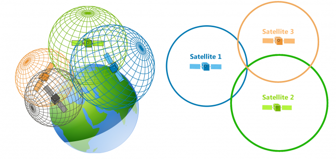
Your basic GPS unit does not use "spheres".
Yes, it does. Please look at your Wiki reference again- "spheres" is the first geometric interpretation mentioned.
Also, see:
https://www8.garmin.com/aboutGPS/index.html (I think Garmin knows abit about the subject)
https://www.faa.gov/about/office_or...nits/techops/navservices/gnss/gps/howitworks/ I'm pretty sure the FAA knows something about it, too.
All it knows is an area of equal time from a pair of satellites.
It depends on the calculation method. This assumes the use of one type of calculation. Also, it isn't "equal time", but rather a constant time difference. An area of equal time from two points, given the same signal propagation speed from those points, describes a plane half-way between the points, perpendicular to the line between those points. I choose to take your statement as meaning "a constant time difference between satellites", as you imply later.
You can't just look at one satellite because you don't know when the pulse you're observing was sent.
Yes, you do. The time the pulse was sent is embedded in the data the satellite send to your GPSr. The uncertainty is when the pulse is received, until the cheap clock in your GPSr is corrected to the rest of the system.
If you look at two you know the differential.
See above, where we discuss "equal time". This statement is more correct than the previous one.
And it doesn't matter how many satellites you have overhead. The geometry for vertical precision is predicated on the fact that they're all on the same side of the earth. GPS signals do not go through the ground.
It does matter, and their geometry matters too. Depending on the calculation method, you can get a good vertical fix, and the "spheres" method does that well since we now have a plethora of satellites overhead (GPS, GLONASS, Galileo, and now, Beidou- modern GPS units receive all of them, so there is always a satellite overhead now).
The introduction to this paper:
https://pdfs.semanticscholar.org/deea/ce584264e1fbd2a080ee39f8e00b7cf43392.pdf does a pretty good job of describing how it works or read the wikipedia article section staring with "More detailed description" in the GPS article:
https://en.wikipedia.org/wiki/Global_Positioning_System
Please consider reading your references. There is more than one way to calculate a position, and the Wiki reference lists several of them.
Another way to get started is to assume a position (where your car was last parked, or get data from another source), use stored satellite ephemeris data, and determine your GPSr clock correction from the time data embedded in the satellite transmission. Apple iDevices have a database of know WiFi locations, and can use those for an initial position fix (I once used my non-cellular iPad for a map in Taiwan in this fashion. Accuracy was within about 100 feet). Cellphones can use an initial position calculated from receiving various cell phone towers. A combination of these methods combined with the GPS work better in "urban canyons", where GPS signals are blocked or reflected by buildings.