losing altitude in holding pattern

ghogue's comment that the procedure turn is part of the INITIAL APPROACH SEGMENT is the key to understanding where to measure the "within 10 nm" from. I quote from the FAA's Instrument Procedure Handbook:
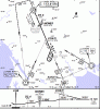
But Lance said as well that he had never seen anything in writing. That's the trouble here. Without something in writing, this is very ambiguous. Sure, the PT is part of the initial segment, but it's not at all clear that this means that the "remain within" notation is therefore measured from the IAF. Sure, that can be argued, but it requires making some assumptions.

He was entirely correct in noting that the 10nm "scale" circle centered on the FAF PAYNE on the PLAN VIEW has nothing to do the "remain within 10 NM" notation for the Initial Approach Segment's PT on the PROFILE view. They are distinct entities on the chart, though fact that the PT barb happens to be depicted inside the 10NM scale circle can understandably cause confusion.
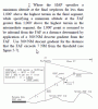
But not only can it cause confusion, it's wrong. If things within that circle are supposed to be to scale, and the "10 NM" notation starts at the VOR, and the PT is depicted outside of those 10 NM, then the chart is incorrect. I think this is a pretty obvious design flaw. Now, I admit that I now think that I was wrong about the range circle as far as NACO's intentions were concerned. At the same time, though, I think this chart design is highly misleading, especially because most charts show a 10 NM ring and a 10 NM notation. After a while, you don't really question that those two things aren't one and the same.

The PT INITIAL Approach Segment leg must originate back at an INITIAL Approach Fix; as has been stated, one can find that by following the black line upslope on the profile view's outbound leg.
Yes, but that doesn't necessarily mean that the 10 NM notation has to start at the IAF.
 
Last edited:
The Jepp chart is more explicit and makes it clearer (that is for those who don't find the NACO chart clear - actually I don't think it is very clear).

I think the NACO chart is clear, and the Jepp chart in error.
 
The "PT distance" I refer to is the limit published in the profile view above the PT altitude. I did not imply that the PT distance was a mandatory distance, but, the max distance specified in the profile view.

The 10nm circle is for scale and although it is centered on PAYNE, it has no bearing on the PT. A procedure turn is the Initial Approach Segment and those begin at an IAF. In this case, BOLES the VOR. PAYNE is the FAF and does not come into play until after you complete the PT (within 10nm of the VOR in this case). There is no requirement or need to even fix PAYNE prior to the PT. It serves no purpose at that point.

Oh, I think it does. I think I'd want to ensure I was southwest of PAYNE when I completed the PT.
 
I think the NACO chart is clear, and the Jepp chart in error.
If that is true you must also think the Jepp chart at KJAC is in error. I think ghogue, Lance (gismo) and Palmpilot are correct but TangoWhiskey is right, this has been a very educational thread.

But no matter who is right it is clear that the NACO charts are ambiguous if no one can find proof in writing what the answer is supposed to be.
 
Last edited:
No, it's not documented anywhere in the main publications that the 10NM restriction starts somewhere in particular (eg., the chart user guide, IPH, IFH, etc.). There might be some obscure NTSB cases or FAA interpretations.

The IPH says the PT is completed "generally within 10 NM of the PT fix, to establish the aircraft inbound on the intermediate or final approach segment." It does not explicitly define "PT fix", but implicitly it's pretty clear that it's the FAF.
 
Actually, it is the whole story in this situation. I didn't say anything about skipping over PAYNE, but it isn't a factor "from the very beginning", it's not a factor until almost the end of the approach i.e., the FAF. There is absolutely no function to PAYNE until after you have completed the PT and inbound to the FAF, PAYNE.

Ignore PAYNE until after you have completed the PT and you may find it to be behind you once you're inbound on the FAC.

The 10nm circle is a scale/reference mark, and info inside it is to scale, however, as I've mentioned before, it has no connection to the PT. In practice, most procedures with PT's have the IAF in the center, but it's merely coincidental that the PT limitation distance and the circle are the same.

Is it also merely coincidental that most procedures with PTs have the IAF and FAF at the same point?

Take a look at the Santa Rosa, CA (KSTS) VOR RWY 32 approach. The circle is centered on the VOR, which is not the IAF, but the IAF is COATI, almost at the outer edge of the circle, and the PT distance is from COATI.

How did you determine from this plate that the PT distance is from COATI?
 
Last edited:
The IPH says the PT is completed "generally within 10 NM of the PT fix, to establish the aircraft inbound on the intermediate or final approach segment." It does not explicitly define "PT fix", but implicitly it's pretty clear that it's the FAF.
I don't disagree, but I just don't know. I think some others here make a good point that the PT fix could also be the fix where the initial approach segment begins....

This has been a great thread. My main complaint now is that the 10NM range circle is wrong and misleading. On some approaches, they actually make it a 15 NM circle to accommodate additional holds and such that are supposed to be to scale. But then in this case the PT is clearly not drawn to scale if the PT fix is the VOR. I realize that the PT barb is a suggestion (except for which side to do the PT on), but the depicted distance from the VOR would obviously be illegal if the 10NM really start at the VOR. This seems like a mistake to me. Also, why does the to scale ring even have a 10 or 15NM notation on it? That's unnecessary and it just confuses the chart user even more because it now seems like that 10NM notation on the circle should have some relevance....
 
Last edited:
One more time. The VOR is the IAF (not PAYNE). A PT (the initial segment) is flown from an IAF, not the FAF. In your example, the reason the 10nm distance is from RIVYO is because it is the IAF, not because it is in the center of the circle. It does not matter if the PT is contained within the circle or not. They are not related except by coincidence.

Repeating it doesn't make it so. You must provide some reliable, verifiable documentation to support your position.

It's limited to within 10 miles of the VOR because it is stated as such in the profile view, i.e. "Remain with 10 NM" just above the PT altitude.
Why do you feel that note is referring to the VOR and not to PAYNE?

Look at the example above for KSTS. COATI, the IAF is barely within the circle and the distance and the PT barb extends outside the circle.
You've said the PT distance for this approach is from COATI. How did you determine it was from COATI and not MONES?
 
Oh, I think it does. I think I'd want to ensure I was southwest of PAYNE when I completed the PT.
Steven,
I agree with you that it actually does come into play inasmuch as ensuring you're beyond PAYNE before flying the PT. However, nothing actually takes place at PAYNE while proceeding outbound on the PT, other than making sure you're beyond it. No altitudes, distances or headings need be complied with in regards to PAYNE. I still stand by my statement that it has no function prior to the PT, but one does need to ensure that you are beyond it.

Thanks for bringing this up.
 
Last edited:
How did you determine from this plate that the PT distance is from COATI?
Are you going to claim Jepp is wrong here too?

attachment.php
 

Attachments

  • ScreenHunter_05 Sep. 24 15.34.gif
    ScreenHunter_05 Sep. 24 15.34.gif
    42.5 KB · Views: 58
Are you going to claim Jepp is wrong here too?

No, the Jepp plate agrees with the NACO plate for this approach. But the question was, "How did you determine from this plate that the PT distance is from COATI?" It was a NACO plate in the message that that question was written in response to.
 
Why would I think that? The NACO and Jepp charts for the KJAC approach are in agreement.
Because you wrote this.

The IPH says the PT is completed "generally within 10 NM of the PT fix, to establish the aircraft inbound on the intermediate or final approach segment." It does not explicitly define "PT fix", but implicitly it's pretty clear that it's the FAF.
And QUIRT is not the FAF.

I see later where you wrote this.

I'm going with QUIRT, the closest fix to the note. I believe these notes always refer to the fix closest to them.
QUIRT is correct but I don't think your reasoning is. COATI is also the closest fix to the note.
 
No, the Jepp plate agrees with the NACO plate for this approach. But the question was, "How did you determine from this plate that the PT distance is from COATI?" It was a NACO plate in the message that that question was written in response to.
Now that I've compared the NACO and Jepp plates I'm convinced that gismo and others are right in saying that it's the first fix on the profile of the NACO charts where the thick line starts even though no one can prove it with a legend. How did you determine it's not COATI?
 
Steven,
I agree with you that it actually does come into play inasmuch as insuring you're beyond PAYNE before flying the PT. However, nothing actually takes place at PAYNE while proceeding outbound on the PT, other than making sure you're beyond it. No altitudes, distances or headings need be complied with in regards to PAYNE. I still stand by my statement that it has no function prior to the PT, but one does need to insure that you are beyond it.

Thanks for bringing this up.

Technically there's not even a requirement that you are beyond PAYNE before starting or finishing the PT but common sense dictates that this would be wise. IOW it would be perfectly legal to make a PT on the airport side of PAYNE and fly an unusually steep approach if you had an aircraft that could drop like a brick (helicopter?) as long as you didn't go below the 7000 PT altitude before getting established inbound.
 
How did you determine it's not COATI?

I didn't, it is COATI.

Question to Jepp users; is there anything in the Jepp legend that tells pilots to stay within 10 miles of the identified fix? The NACO plates state, "Remain within 10 NM", while the Jepp plates state, "10 NM from (fix)" but do not tell pilots to remain within ten miles of the fix.
 
I didn't, it is COATI.
It sure didn't seem like you thought so when you wrote this.
You've said the PT distance for this approach is from COATI. How did you determine it was from COATI and not MONES?
Question to Jepp users; is there anything in the Jepp legend that tells pilots to stay within 10 miles of the identified fix? The NACO plates state, "Remain within 10 NM", while the Jepp plates state, "10 NM from (fix)" but do not tell pilots to remain within ten miles of the fix.
Seriously?
 
If that is true you must also think the Jepp chart at KJAC is in error. I think ghogue, Lance (gismo) and Palmpilot are correct but TangoWhiskey is right, this has been a very educational thread.

But no matter who is right it is clear that the NACO charts are ambiguous if no one can find proof in writing what the answer is supposed to be.

Just to be clear, I referred to my conclusion on this as a GUESS. (See post #33, last sentence.) The reason for my guess is that I looked through a bunch of Jepp charts, they seem to be consistent on this, and Jepp invented instrument approaches, but let's face it, that's nothing more than a plausibility argument. Instead of guessing that the start of the outbound segment of the PT is the "PT fix," one could just as easily guess that the end of the inbound segment is the PT fix.

If someone has a lot of time on their hands, maybe the TERPS manual has the answer:

http://www.faa.gov/regulations_poli....cfm/go/document.information/documentID/11698
 
Last edited:
Why does it seem like that to you? That message said nothing about my thoughts on the matter.

You know, you could just tell us what you think, instead of playing twenty questions. :)
 
Last edited:
Question to Jepp users; is there anything in the Jepp legend that tells pilots to stay within 10 miles of the identified fix?

Yes. It's on page 108 of the Introduction. They show an example that has "10 NM" next to the plan view of a procedure turn, and an explanatory note that says "Procedure turn outbound limit. Turn to be completed within 10 NM."
 
I'm going with QUIRT, the closest fix to the note. I believe these notes always refer to the fix closest to them.

That's certainly as plausible a guess as any. It would be nice if someone could find an FAA publication that actually says which fix it is.
 
Just to be clear, I referred to my conclusion on this as a GUESS. (See post #33, last sentence.) The reason for my guess is that I looked through a bunch of Jepp charts, they seem to be consistent on this, and Jepp invented instrument approaches, but let's face it, that's nothing more than a plausibility argument. Instead of guessing that the start of the outbound segment of the PT is the "PT fix," one could just as easily guess that the end of the inbound segment is the PT fix.

If someone has a lot of time on their hands, maybe the TERPS manual has the answer:

http://www.faa.gov/regulations_poli....cfm/go/document.information/documentID/11698

There's still a significant lack of definition but this excerpt is pretty clear on the topic:

234. INITIAL APPROACH SEGMENT BASED ON A PT. A PT shall be specified when it is necessary to reverse direction to establish the aircraft on an intermediate or FAC except as specified in paragraph 234e. A PT begins by overheading a facility or fix which meest the criteria for a holding fix (see paragraph 287b), or a FAF (see paragraph 287c). The procedure shall specify the PT fix, the outbound and inbound course, the distance within which the PT shall be completed, and the direction of the PT. ...

Since the PT is clearly associated with the fix that begins the initial approach segment (i.e. the IAF) it seems pretty obvious that the "remain within" distance is relative to the beginning of the PT based initial segment according to the approach design requirements. While this isn't ironclad proof in the form of a quoted regulation that states my premise exactly, it's definite enough for me. Based on this and what I see on NACO plates, I can only conclude that the distance in question is always relative to the fix where the segment leading to the PT on the profile view begins (baring an actual error on the diagram).

It's also apparent that Jepp has concluded (correctly it seems) that this is a point of some confusion among pilots since they have chosen to put an explicit reference to the "remain within" origin.
 
And page 66 of this FAA Order makes it REALLY clear, even labeling that spot on the profile view as "PT Fix":

http://rgl.faa.gov/Regulatory_and_G...7086257068005edcd7/$FILE/826019C_3_Part-1.pdf
It's this diagram, which looks like a rough sketch of what would become the approach chart. There are other examples following this one too. So they do measure from where the thick line starts. Nice find, although I don't think it should be this difficult to prove. Jepp has the better idea for us dense pilots.

attachment.php
 

Attachments

  • ScreenHunter_06 Sep. 24 21.29.gif
    ScreenHunter_06 Sep. 24 21.29.gif
    23.6 KB · Views: 58
I'm saving a bookmark to this thread!
 
That was also very educational for me, I have to take back some of my earlier statements.
I give credit to Jeppesen for always naming which fix this 10 nm is from. But in view of the FAA documentation provided here things we'll be a lot clearer when using NACO charts. By the way I re-read Machado's statements on the subject in his book and now they have more meaning to me (in view of the info above), I only wished he used even more direct language.
 
Last edited:
I'm going with QUIRT, the closest fix to the note. I believe these notes always refer to the fix closest to them.
Steven,

You are right about the QUIRT being the correct answer but you are incorrect that the "closest" has anything to do with it. What is important is that QUIRT is the IAF and is the fix from which the letdown to the PT commences. I hope the included documentation will help you see the light of day like it did for me. :yes:
 
Last edited:
I give credit to Jeppesen for always naming which fix this 10 nm is from.

The Jepp charts I looked at showed that they only name the PT fix when there is potential ambiguity. When the same fix is used both outbound and inbound, they don't do it.
 
Neither are false. Not to split hairs, but I never said everything inside is to scale. Obstacles, terrain features and of course airports certainly are, but procdeure tracks are not necessarily. When approaches are drawn, the length of the procedure turn line can vary and not necessarily to scale. Look at a number of charts and you will see this. The Jackson Hole ILS or LOC RWY 19 above provides an example. The PT limit is 10nm, but one can see the actual length is less than 10 miles. My claim, as you put it, that the 10 miles is in reference to the VOR is correct for the reason that I have repeated all along. The VOR is the IAF and the PT is flown from the an IAF.

You say I need to calm down, but I fail to see anywhere in my posts that I'm anything but calm. There has been no overtatement and no self-contradictory positions by me. You are simply trying to make me appear irrational which I am not, to bolster your points.

Okay then, no "overtatement" and no self-contradictory positions. No irrational behavior here at all. By all means, enjoy your opinion, have fun with it.
 
Can we all agree that there are two things NACO could do to improve the usability of these plates:

- Remove the distance (10 NM, etc.) notation on the to-scale rings. Two reasons. First, the to-scale ring serves to show that anything contained within that ring is to scale. Therefore, it's about what's inside the circle, not about what the radius of the circle is. I don't see how knowing the radius actually adds any useful information. Secondly, since the "Remain within 10 NM" notation and the 10 NM to-scale circle often coincide, many people (me included) will associate the to-scale circle with the notation, especially because the notation doesn't explicitly state to what it is in reference.

- Make sure that if the PT is depicted within the to-scale ring, it is depicted correctly. For the approach here, that means that it can't be depicted in such a way that it's a violation of the "Remain within 10 NM" notation. This is quite problematic - besides being outright wrong, it further reinforces the believe that the "Remain within 10 NM" notation and the to-scale circle must be related since the chart would be clearly inconsistent otherwise.

I think these two changes would improve the readability of the plates a lot. Last time I spoke with NACO, they seemed eager to hear ideas on chart improvements, so depending on what you guys think, I might pass these on to them.

Thoughts?

-Felix
 
- Make sure that if the PT is depicted within the to-scale ring, it is depicted correctly. For the approach here, that means that it can't be depicted in such a way that it's a violation of the "Remain within 10 NM" notation. This is quite problematic - besides being outright wrong, it further reinforces the believe that the "Remain within 10 NM" notation and the to-scale circle must be related since the chart would be clearly inconsistent otherwise.
Since there are a number of different ways to do a PT and the size of it depends, to a degree, on the speed of the airplane and the wind, it would be hard to depict one accurately. However, maybe they could depict the maximum size it should be. I do agree that if the maximum size PT would take you outside the ring it should be shown crossing it.

I think these two changes would improve the readability of the plates a lot. Last time I spoke with NACO, they seemed eager to hear ideas on chart improvements, so depending on what you guys think, I might pass these on to them.

Thoughts?
I think it's a great idea to pass this on to them.

I also think that when the fix that the distance is measured from could be ambiguous they should state what is is, just like Jepp. The fact that the majority of the people here were mistaken or unsure is a statement about the clarity of the charts. Sure we figured it out at the end which is a good academic exercise but that's not what charts are for. They should be able to be interpreted correctly the first time you read them.
 
Great idea. I emailed them:

FAA, AeroNav Services AJW-37
6500 S. MacArthur Blvd
Oklahoma City, OK 73169

Telephone.......405-954-3027
E-mail...............9-AMC-Aerochart@faa.gov
 
Back
Top