olasek
Pattern Altitude
I have a question about this VOR-DME approach at KALM.
http://www.airnav.com/depart?http://204.108.4.16/d-tpp/1010/05130VD3.PDF
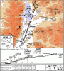
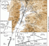
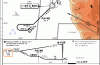
Assuming flying the full approach with PT I would find it impossible to lose the necessary altitude, yet the comment on the chart seems to suggest that if I arrive at the VOR at 12000 ft I should proceed with the approach. I am assuming that if I asked ATC I would easily get permission to lose some altitude in the holding pattern before flying outbound from the VOR. I tried this approach in a simulator and in a light aircraft I simply find descending from 12000 ft (while at VOR) all the way to MDA during the course of this approach simply impossible without resorting to some kamikaze-like flying.
http://www.airnav.com/depart?http://204.108.4.16/d-tpp/1010/05130VD3.PDF
Assuming flying the full approach with PT I would find it impossible to lose the necessary altitude, yet the comment on the chart seems to suggest that if I arrive at the VOR at 12000 ft I should proceed with the approach. I am assuming that if I asked ATC I would easily get permission to lose some altitude in the holding pattern before flying outbound from the VOR. I tried this approach in a simulator and in a light aircraft I simply find descending from 12000 ft (while at VOR) all the way to MDA during the course of this approach simply impossible without resorting to some kamikaze-like flying.
Last edited:
")